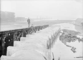
Two men standing on a pier beside a sewer pipe
- COV-S371-F39-: CVA 656-13
- Item
- [1912]
Part of City of Vancouver fonds
Item is a photograph showing two men at the storm sewer outfall at Heather Street.
206389 results with digital objects Show results with digital objects
Two men standing on a pier beside a sewer pipe
Part of City of Vancouver fonds
Item is a photograph showing two men at the storm sewer outfall at Heather Street.

Man seated in a horse-drawn buggy under the viaduct
Part of City of Vancouver fonds

Court House and the King Edward VII fountain
Part of City of Vancouver fonds
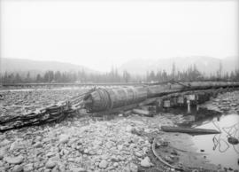
Sewer pipe on trestle under construction
Part of City of Vancouver fonds

St. Francis Hotel and CPR Station, looking west down Cordova Street
Part of City of Vancouver fonds

Looking south on Fraser near 67th Avenue
Part of City of Vancouver fonds
Photograph shows Webb's Shoe Repairs and a wooden sidewalk.

Looking east down Georgia viaduct
Part of City of Vancouver fonds
Photograph shows Marshall-Wells B.C. Limited on the left and the Empress Theatre in the distance.

Looking east down Georgia viaduct
Part of City of Vancouver fonds
Photograph shows a sign reading, Street closed by order of City Engineer.

Sidewalk on Water Street west of Carrall
Part of City of Vancouver fonds

Wooden sidewalk on unidentified street
Part of City of Vancouver fonds

Detail of the west side of Fraser, north of 67th Avenue
Part of City of Vancouver fonds
Part of City of Vancouver fonds

Part of City of Vancouver fonds

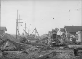
Men standing by sewer construction
Part of City of Vancouver fonds

Sewer construction, possibly on Venables Street
Part of City of Vancouver fonds

Sewer construction, possibly on Venables Street
Part of City of Vancouver fonds
Sewer construction, possibly on Venables Street
Part of City of Vancouver fonds

Sewer construction, likely on 6th Avenue
Part of City of Vancouver fonds

Sewer construction, possibly on Venables Street
Part of City of Vancouver fonds
Sewer construction, possibly on Venables Street
Part of City of Vancouver fonds

Plan of sea wall site, Main Street, and surrounding properties
Part of City of Vancouver fonds
Item is a map showing sewers, pier headlines, land ownership, streets, parks and rail lines in the area east of False Creek at Main Street and Terminal Avenue.
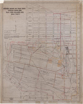
Proposed Raymur Ave. trunk sewer diverting sewage from False Creek reclaimed area
Part of City of Vancouver fonds
Item is a map showing detailed plans associated with the Raymur Ave. trunk sewer. The map contains several revisions and updates dated Dec. 1936, Feb. and Mar. 1937, May 1937, Aug. 1938 and Sept. 1941 of utilities infrastructure in False Creek east of Main Street.
Vancouver (B.C.). Engineer's Office

Proposed Raymur Ave. trunk sewer diverting sewage from False Creek reclaimed area
Part of City of Vancouver fonds
Item is a map showing detailed plans associated with the Raymur Ave. trunk sewer. Annotations show the heights of top fill, bottom and water relative to an unidentified benchmark.
Vancouver (B.C.). Engineer's Office

Proposed Raymur Ave. trunk sewer diverting sewage from False Creek reclaimed area
Part of City of Vancouver fonds
Item is a map showing detailed plans associated with the Raymur Ave. trunk sewer. Annotations show sewer lines.
Vancouver (B.C.). Engineer's Office
Plan of arch to be erected on Georgia Street for the Diamond Jubilee celebration
Part of City of Vancouver fonds
Item is an architectural drawing of a ceremonial arch erected for the the Diamond Jubilee celebrations. The drawing depicts plans, elevations and details.
Vancouver (B.C.). Engineer's Office

Part of City of Vancouver fonds
Section 19 : Nanaimo Street to Ferndale Street to Clark Drive to Second Avenue
Part of City of Vancouver fonds
Item is a section showing the area bounded by Nanaimo Street, Ferndale Street, Clark Drive and Second Avenue. Annotations show areas zoned M-1 Light Industrial and City-owned property.

Section 20 : Clark Drive to Prior Street to Main Street to Great Northern Way
Part of City of Vancouver fonds
Item is a section showing the area bounded by Clark Drive, Prior Street, Main Street and Great Northern Way. Annotations show areas zoned M-1 Light Industrial, M-2 Heavy Industrial and City-owned property.

Section 30 : Oak Street to Third Avenue to Maple Street to Fourteenth Avenue
Part of City of Vancouver fonds
Item is a section showing the area bounded by Oak Street, Third Avenue, Maple Street and Fourteenth Avenue, Annotations show areas zoned M-1 Light Industrial, M-2 Heavy Industrial and City-owned property.

Section 34: Rupert Street to Fifth Avenue to Nanaimo Street to Grandview Highway
Part of City of Vancouver fonds
Item is a section showing the area bounded by Rupert Street, Fifth Avenue, Nanaimo Street and Grandview Highway, Annotations show areas zoned M-1 Light Industrial and M-2 Heavy Industrial.

Section 35 : Boundary Road to Fifth Avenue to Rupert Street to Grandview Highway
Part of City of Vancouver fonds
Item is a section showing the area bounded by Boundary Road, Fifth Avenue, Rupert Street and Grandview Highway, Annotations show areas zoned M-1 Light Industrial and M-2 Heavy Industrial.
Section 37 : Boundary Road to Twenty-second Avenue to Rupert Street to Wellington Avenue
Part of City of Vancouver fonds
Item is a section showing the area bounded by Boundary Road, Twenty-second Avenue, Rupert Street and Wellington Avenue.

Section 42 : Ontario Street to Sixteenth Avenue to Oak Street to Twenty-eighth Avenue
Part of City of Vancouver fonds
Item is a section showing the area bounded by Ontario Street, Sixteenth Avenue, Oak Street and Twenty-eighth Avenue.

Section 45 : Blenheim Street to Fourteenth Avenue to Discovery Street to King Edward Avenue
Part of City of Vancouver fonds
Item is a section showing the area bounded by Blenheim Street, Fourteenth Avenue, Discovery Street and King Edward Avenue.

Section 46 : Discovery Street to Fourteenth Avenue to Blanca Street to Sixteenth Avenue
Part of City of Vancouver fonds
Item is a section showing the area bounded by Discovery Street, Fourteenth Avenue, Blanca Street and Sixteenth Avenue.

Section 47 : Blenheim Street to King Edward Avenue to Camosun Street to Thirty-third Avenue
Part of City of Vancouver fonds
Item is a section showing the area bounded by Blenheim Street, King Edward Avenue, Camosun Street and Thirty-third Avenue.

Section 51 : Inverness Street to Twenty-eighth Avenue to Ontario Street to Thirty-seventh Avenue
Part of City of Vancouver fonds
Item is a section showing the area bounded by Inverness Street, Twenty-eighth Avenue, Ontario Street and Thirty-seventh Avenue.

Section 58 : Nanaimo Street to Forty-first Avenue to Inverness Street to Forty-ninth Avenue
Part of City of Vancouver fonds
Item is a section showing the area bounded by Nanaimo Street, Forty-first Avenue, Inverness Street and Forty-ninth Avenue.

Section 61 : Oak Street to Thirty-third Avenue to Cypress Street to Forty-first Avenue
Part of City of Vancouver fonds
Item is a section showing the area bounded by Oak Street, Thirty-third Avenue, Cypress Street and Forty-first Avenue.

Section 62 : Oak Street to Forty-first Avenue to Cypress Street to Forty-ninth Avenue
Part of City of Vancouver fonds
Item is a section showing the area bounded by Oak Street, Forty-first Avenue, Cypress Street and Forty-ninth Avenue.

Section 69 : Macdonald Street to Forty-ninth Avenue to Musqueum Indian Reserve to Fraser River
Part of City of Vancouver fonds
Item is a section showing the area bounded by Macdonald Street, Forty-ninth Avenue, Musqueum Indian Reserve and Fraser River.

Section 74 : Nanaimo Street to Forty-ninth Avenue to Inverness Street to Sixty-first Avenue
Part of City of Vancouver fonds
Item is a section showing the area bounded by Nanaimo Street, Forty-ninth Avenue, Inverness Street and Sixty-first Avenue.

Section 75 : Kerr Street to Forty-ninth Avenue to Nanaimo Street to Sixty-first Avenue
Part of City of Vancouver fonds
Item is a section showing the area bounded by Kerr Street, Forty-ninth Avenue, Nanaimo Street and Sixty-first Avenue.
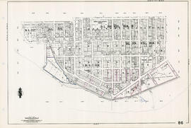
Section 86 : Laurel Street to Sixty-seventh Avenue to Angus Drive to Fraser River
Part of City of Vancouver fonds
Item is a section showing the area bounded by Laurel Street, Sixty-seventh Avenue, Angus Drive and the Fraser River. Annotations show areas zoned M-1 Light Industrial and M-2 Heavy Industrial and City-owned properties.
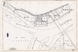
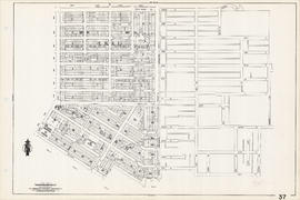
Section 87 : Heather Street to Seventy-fifth Avenue to Barnard Street to Fraser River
Part of City of Vancouver fonds
Item is a section showing the area bounded by Heather Street, Seventy-fifth Avenue, Barnard Street and the Fraser River. Annotations show areas zoned M-1 Light Industrial and M-2 Heavy Industrial and City-owned properties.
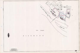
Section 89 : D.L. 308, D.L. 317, D.L. 318 and D.L. 5214
Part of City of Vancouver fonds
Item is a section showing D.L. 308, D.L. 317, D.L. 318 and D.L. 5214, west of Barnard Street and SW Marine Drive. Annotations show areas zoned M-1 Light Industrial and M-2 Heavy Industrial and City-owned properties.

Plan of district lot boundaries, City of Vancouver, B.C.
Part of City of Vancouver fonds
Item is a map of Vancouver showing district lot boundaries.
The map identifies First Nations reserves, the University Endowment Lands, Stanley Park, Old Granville Townsite and Hastings Townsite. On the verso of the map is a legend indicating the colours used on the maps in this file to define areas of tax sale property for sale, no water, street widening - drainage, replotting, reserved school, reserved park, sundry, capital assets (except schools and parks), schools, and parks.
Vancouver (B.C.). Office of the City Engineer

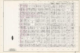
Sheet 10 : Clark Drive to Slocan Street and Burrard Inlet to Triumph Street
Part of City of Vancouver fonds
Item is a section showing the area from Clark Drive to Slocan Street and aterfront to Triumph Street. Includes streets and roads, blocks, lots, legal descriptions, railways, parks, boys' detention home and businesses along the waterfront. The Town of Hastings is indicated on the map. Map is hand coloured to show tax sale property for sale, property with no water, street widening and drainage, replotting, reserved land for schools, reserved land for parks, sundry land, capital assets not including schools and parks, schools, and parks, as applicable.
Vancouver (B.C.). Office of the City Engineer

Sheet 8 : McLean Drive to Slocan Street and William Street to Seventh Avenue
Part of City of Vancouver fonds
Item is a section showing the area from McLean Drive to Slocan Street and William Street to Seventh Avenue. Includes streets and roads, blocks, lots, legal descriptions, railways, parks, schools and some businesses. Map is hand coloured to show tax sale property for sale, property with no water, street widening and drainage, replotting, reserved land for schools, reserved land for parks, sundry land, capital assets not including schools and parks, schools, and parks, as applicable. Some annotations have been made in pencil.
Vancouver (B.C.). Office of the City Engineer

Sheet 16 : Maple Street to Oak Street and False Creek to Sixteenth Avenue
Part of City of Vancouver fonds
Item is a section showing Maple Street to Oak Street and False Creek to Sixteenth Avenue. Includes streets and roads, blocks, lots, legal descriptions, railways, schools and parks. Indicates crown land leased to the C.P.R. and other bodies. Map is hand coloured to show tax sale property for sale, property with no water, street widening and drainage, replotting, reserved land for schools, reserved land for parks, sundry land, capital assets not including schools and parks, schools, and parks.
Vancouver (B.C.). Office of the City Engineer