
- AM1594-: MAP 818-: LEG1329.8
- Part
- 1954
Part of City of Vancouver Archives technical and cartographic drawing collection
Part contains a street map of Greater Vancouver.
246 results with digital objects Show results with digital objects
Part of City of Vancouver Archives technical and cartographic drawing collection
Part contains a street map of Greater Vancouver.
Part of City of Vancouver Archives technical and cartographic drawing collection
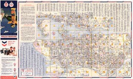
Part is a street map of Greater Vancouver (including West Vancouver, North Vancouver, Vancouver, Burnaby New Westminster and parts of Richmond, Coquitlam and Surrey). The sheet also includes a street index and tourist information for U.S. border crossing

Part of City of Vancouver Archives technical and cartographic drawing collection
Part is a street map of Greater Vancouver, including West Vancouver, North Vancouver, and the western portion of Burnaby. The map includes concentric circles centred on the Bekins head office in downtown, noting distances in miles.

Part of City of Vancouver Archives technical and cartographic drawing collection
Part is the outer/back side of an unfolded brochure for Union Steamships. The sheet includes text describing the company's services and vessels, photographs of various vessels and locations served, and a map showing the various routes in the area.
Union Steamships (Vancouver, B.C.)
Target area civil defence survival instructions
Part of City of Vancouver Archives technical and cartographic drawing collection

Part of City of Vancouver Archives technical and cartographic drawing collection
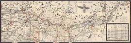
Part is a map of a portion of the Rocky Mountains including Rocky Mountains Park, Yoho Park, Kootenay Park, Glacier Park, and Revelstoke Park. Map shows rail lines, steamship routes, roads, trails, waterfalls, glaciers, rivers, elevations, and locations of amenities.
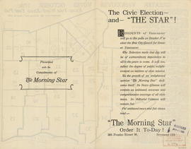
The civic election - and "The Star"!
Part of City of Vancouver Archives technical and cartographic drawing collection
Part contains text advertising The Morning Star newspaper and assuring readers of its political neutrality.

The civic election - and "The Star"!
Part of City of Vancouver Archives technical and cartographic drawing collection
Part contains text advertising The Morning Star newspaper and assuring readers of its political neutrality.

The Estate of Joseph Martin, K.C., MP
Part of City of Vancouver Archives technical and cartographic drawing collection
Part is the front side of the fold-out brochure; it includes promotional information about the estate, Vancouver, the climate, economy, land speculation in the city.
Part of City of Vancouver Archives technical and cartographic drawing collection
Part is a map of the greater Vancouver area, showing communities across the region, with pictographs representing various communities. The map also includes a mileage table showing driving distances between various communities in Greater Vancouver.
British Columbia. Travel Bureau
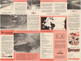
The Port of Vancouver, British Columbia
Part of City of Vancouver Archives technical and cartographic drawing collection
Part is the front side of a brochure on the Port of Vancouver. The page includes information on the port's history, facilities, berthing accommodations, development and

The service route to - from - through industrial southwestern British Columbia
Part of City of Vancouver Archives technical and cartographic drawing collection
Part is a map depicting Greater Vancouver east to Chilliwack, showing the locations of B.C. Hydro rail routes, routes of other rail companies, interchanges, industrial development sites, and municipal boundaries and 1961 census figures.

Part of City of Vancouver Archives technical and cartographic drawing collection

Part of City of Vancouver Archives technical and cartographic drawing collection

Tidal current chart, Vancouver Harbour : inside back cover
Part of City of Vancouver Archives technical and cartographic drawing collection
Part contains information about the survey data upon which the charts are based, and contact information for the Canadian Hydrographic Service.

Tidal current chart, Vancouver Harbour : maximum ebb at First Narrows
Part of City of Vancouver Archives technical and cartographic drawing collection

Tidal current chart, Vancouver Harbour : maximum flood at First Narrows
Part of City of Vancouver Archives technical and cartographic drawing collection

Tidal current chart, Vancouver Harbour : one hour after maximum ebb at First Narrows
Part of City of Vancouver Archives technical and cartographic drawing collection

Tidal current chart, Vancouver Harbour : one hour after maximum flood at First Narrows
Part of City of Vancouver Archives technical and cartographic drawing collection

Tidal current chart, Vancouver Harbour : one hour before maximum ebb at First Narrows
Part of City of Vancouver Archives technical and cartographic drawing collection

Tidal current chart, Vancouver Harbour : one hour before maximum flood at First Narrows
Part of City of Vancouver Archives technical and cartographic drawing collection

Tidal current chart, Vancouver Harbour : three hours after maximum ebb at First Narrows
Part of City of Vancouver Archives technical and cartographic drawing collection

Tidal current chart, Vancouver Harbour : three hours after maximum flood at First Narrows
Part of City of Vancouver Archives technical and cartographic drawing collection

Tidal current chart, Vancouver Harbour : two hours after maximum ebb at First Narrows
Part of City of Vancouver Archives technical and cartographic drawing collection

Tidal current chart, Vancouver Harbour : two hours after maximum flood at First Narrows
Part of City of Vancouver Archives technical and cartographic drawing collection

Tidal current chart, Vancouver Harbour : two hours before maximum ebb at First Narrows
Part of City of Vancouver Archives technical and cartographic drawing collection

Tidal current chart, Vancouver Harbour : two hours before maximum flood at First Narrows
Part of City of Vancouver Archives technical and cartographic drawing collection

Tidal current charts, Vancouver Harbour : inside front cover
Part of City of Vancouver Archives technical and cartographic drawing collection
Part contains explanatory text to be used in conjunction with the tidal current charts in the booklet.

Tidal current charts, Vancouver Harbour, British Columbia : front cover
Part of City of Vancouver Archives technical and cartographic drawing collection

Part of City of Vancouver Archives technical and cartographic drawing collection
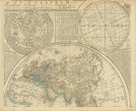
Part depicts the upper left hand quadrant of the map, and includes a diagram of the solar system, a table of dimensions of bodies in the solar system, a chart of constellations viewable in the northern hemisphere, text on geographical definiations and the cause of the tides, and a map of the northern half of the Americas.
Dunn, Samuel
Part of City of Vancouver Archives technical and cartographic drawing collection
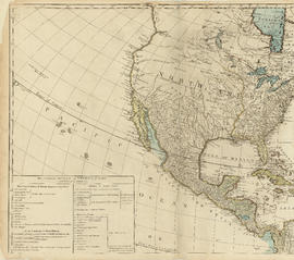
Part is the top left hand quadrant of a map of the Americas, and depicts North America and the north-west portion of South America. The sheet also includes a list of territories and islands in North America and appears to relate to territorial divisions as a result of the Treaty of Paris and the Treaty of Versailles (1783).
Part of City of Vancouver Archives technical and cartographic drawing collection
Part depicts a chart of the astronomical latitude & longitude analemma, a table showing values of the place of the sun in the ecliptic & declinatiobn, a chart of the constellations viewable in the southern hemisphere, text on geographical definitions and the cause of the tides, and a map of the northern portion of Africa, Europe and Asia.
Dunn, Samuel
Part of City of Vancouver Archives technical and cartographic drawing collection
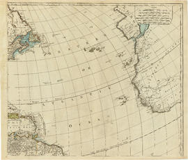
Part is the top right portion of a map of the Americas, and depicts the north-eastern portion of the Canadian coast, the eastern portion of the West Indies, the north-east corner of South America and the coastal areas of south-west Europe and wesern Africa.

Tourist map of Greater Vancouver
Part of City of Vancouver Archives technical and cartographic drawing collection
Part is a sheet with two maps. The main map shows a pictorial view of Greater Vancouver, including the location of major roads and tourist attractions. Drawings of "the most important single objects on totem poles of the Pacific Northwest Indians" form a decorative border. The inset map shows downtown Granville Street and the location of the Scenery Shop.
Transit system map of Greater Vancouver
Part of City of Vancouver Archives technical and cartographic drawing collection
Part is a map showing the routes of various BC Electric transit services. The inset map shows the Forest Hills/Canyon Heights area. The map also includes a guide to Vancouver street numbers.

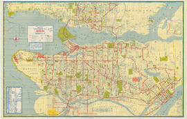
Transit system map of Greater Vancouver, B.C.
Part of City of Vancouver Archives technical and cartographic drawing collection
Part contains a map of Greater Vancouver showing bus lines, route numbers, B.C. Electric installations, block numbers, points of interest and amenities; an inset map showing streets in Gleneagles, Whytecliff, and Horseshoe Bay; and an inset map showing streets in Port Moody, Coquitlam, and Maillardville.

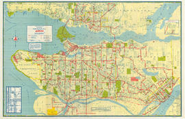
Transit system map of Greater Vancouver, B.C.
Part of City of Vancouver Archives technical and cartographic drawing collection
Part is a map sheet with a main map showing the various B.C. Electric transit routes in Greater Vancouver, including Vancouver, Richmond, North Vancouver, Burnaby and New Westminster.

Transit system map of Greater Vancouver, B.C.
Part of City of Vancouver Archives technical and cartographic drawing collection
Part contains a map of Greater Vancouver showing bus lines, route numbers, B.C. Electric installations, block numbers, points of interest and amenities; an inset map showing streets in Gleneagles, Whytecliff, and Horseshoe Bay; and an inset map showing streets in Port Moody, Coquitlam, and Maillardville.
Part of City of Vancouver Archives technical and cartographic drawing collection
Part is the inner side of the cover, in which the map was attached map was folded. The page lists dancehalls and licensed hotels in the City of Vancouver.

Vancouver - the third largest city of the dominion, and Canada's chief Pacific port
Part of City of Vancouver Archives technical and cartographic drawing collection
Part contains information on Vancouver's history and government, and on the purpose and benefits of town planning.
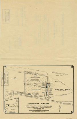
Part of City of Vancouver Archives technical and cartographic drawing collection
Part is a map shows a proposed plan for the design of Vancouver Airport at Spanish Banks, along with surrounding gardens, a stadium, parks and beaches.

Vancouver airport. Design for Spanish Banks
Part of City of Vancouver Archives technical and cartographic drawing collection
Part is the front page of a brochure, showing cost estimates for various elements of the development.

Vancouver city and suburban lines
Part of City of Vancouver Archives technical and cartographic drawing collection
Part consists of a map of streetcar and interurban rail lines in Vancouver.

Vancouver city and suburban lines
Part of City of Vancouver Archives technical and cartographic drawing collection
Part consists of a map of streetcar and interurban rail lines in Vancouver.

Vancouver city and suburban lines
Part of City of Vancouver Archives technical and cartographic drawing collection
Part is the back side of an informational pamphlet published by the BC Electric Railway Co. showing street car lines, interurban lines, bus routes and parks.
Part of City of Vancouver Archives technical and cartographic drawing collection
Part is the verso side of a sheet, containing a map depicting major buildings in downtown Vancouver, colour coded by type, as well as a street index and a short history of Vancouver.