
Sectional map and street directory of Vancouver, British Columbia : street directory
- AM1519-: PAM Und. 500-: LEG1319.178
- Part
- [ca. 1943]
220 results with digital objects Show results with digital objects
Sectional map and street directory of Vancouver, British Columbia : street directory

Sectional map and street directory of Vancouver, British Columbia : street directory

Sectional map and street directory of Vancouver, British Columbia : street directory

Sectional map and street directory of Vancouver, British Columbia : street directory

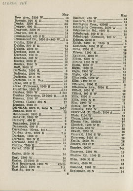
Sectional map and street directory of Vancouver, British Columbia : street directory

Sectional map and street directory of Vancouver, British Columbia : street directory
Sectional map and street directory of Vancouver, British Columbia : street directory

Sectional map and street directory of Vancouver, British Columbia : street directory

Sectional map and street directory of Vancouver, British Columbia : street directory

Sectional map and street directory of Vancouver, British Columbia : street directory

Sectional map and street directory of Vancouver, British Columbia : street directory

Sectional map and street directory of Vancouver, British Columbia : street directory

Sectional map and street directory of Vancouver, British Columbia : street directory

Sectional map and street directory of Vancouver, British Columbia : street directory

Sectional map and street directory of Vancouver, British Columbia : title page


Sectional map and street directory of Vancouver, British Columbia : Vancouver street car routes


Shortest - fastest : fair to fair : United Air Lines : side 1
Part contains text about United Air Lines service including reservation and schedule information.

Shortest - fastest : fair to fair : United Air Lines : side 2
Part contains a map showing United Air Lines destinations accompanied by text with information about fair to fair service.

Standard tourist's guide to Stanley Park : cover page
Part is the cover page for pamphlet about Stanley Park featuring a photo captioned: "Lily Pond and Band Stand at Refreshment Pavilion" taken by Gowen-Sutten & Co. Ltd.

Standard tourist's guide to Stanley Park : Index to points of interest
Part is the index to points of interest found on the Stanley Park map in pamphlet. Includes automobile routes, street car routes to park, viewpoints, gardens, and bodies of water.

Standard tourist's guide to Stanley Park : page 1
Part contains historical information and general information about visiting Stanley Park.

Standard tourist's guide to Stanley Park : Stanley Park, Vancouver, B.C., key plan
Part is a map showing points of interest in Stanley Park, including car lines, roads and car routes, buildings, beaches, and trails.

Standard tourist's guide to Stanley Park, a few facts about Vancouver : back cover
Part is the back cover of pamphlet and contains facts about the City of Vancouver.

Sylvia Court : Gilford at Beach, Vancouver, B. C. : side 1
Part shows an illustration of Sylvia Court and an illustration showing the route to Sylvia Court without driving through the city.

Sylvia Court : Gilford at Beach, Vancouver, B. C. : side 2
Part contains text advertising Sylvia Court accompanied by photos of the hotel interior, and English Bay.
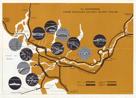
The Lower Mainland traffic system : B.C. Government Lower Mainland Highway Traffic System
Part contains a map showing planned, under construction, and completed double and single lane highways on the Lower Mainland. Map extends from Langdale to Hope to Tsawassen. Map includes illustrations of various bridges, tunnels and ferries that are part of the highway system.

The Lower Mainland traffic system : side 1
Part contains textual information about the Lower Mainland highway system. Part includes a letter from Minister Gaglardi and is illustrated with photographs of Lower Mainland highways.

The scenic route of British Columbia : Pacific Great Eastern Railway : side 1
Part contains the pamphlet cover page and a map showing the route of the Pacific Great Eastern Railway. Map shows town names, bodies of water, and bridges. Map extends from the Canada/U.S. border to Summit Lake.

The scenic route of British Columbia : Pacific Great Eastern Railway : side 2
Part consists of text listing points of interest along the Pacific Great Eastern Railway route. List shows the mileage and the altitude of each point of interest.
The Western Guide, index to map
Part contains an index to the map on the other side, including places of interest, hospitals, depots, streets, Vancouver car lines, and advertisements for Mission Studio and Union Steamship Co. of B.C. Limited.

This time . . . go by bus : Pacific Stage Lines : side 1
Part contains cover of pamphlet, contact and rate information, and is illustrated with photos of a bus depot, and the interior and exterior of buses with passengers.

This time . . . go by bus : Pacific Stage Lines : side 2
Part contains text addressing Pacific Stage Lines schedule, accommodations, route, and bus terminal information. A map accompanies text showing bus routes from Vancouver through the United States and up to Halifax.

Tourists' map of Greater Vancouver : cover
Part contains the front and back covers of the pamphlet, a map of Downtown Vancouver, a map of the downtown section of New Westminster, and information for tourists, including interesting facts about Vancouver. Maps show principal street names and some building names.

Tourists' map of Greater Vancouver : inside cover
Part consists of the inside cover of pamphlet containing information about David Spencer Limited.

Tourists' map of Greater Vancouver : map of downtown Vancouver and map of New Westminster
Part contains a map of Downtown Vancouver, a map of the downtown section of New Westminster, and information for tourists including interesting facts about Vancouver. Maps show principal street names and some building names.

Part consists of a map of Greater Vancouver. Map extends from Howe Sound to Dome Mountain to Pitt River to Lulu Island. Map shows principal street names, golf and country clubs, bodies of water and city limits. Part contains textual information about parking regulations for the David Spencer store.
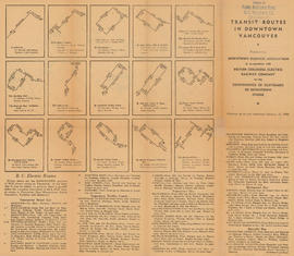
Transit routes in downtown Vancouver : side 1
Part contains illustrations of the downtown Vancouver portions of the B.C. Electric transit routes and text descriptions of all B.C. Electric transit routes in Vancouver, New Westminster, North Vancouver, Richmond, and Burnaby effective up to and including February 15, 1950.

Transit routes in downtown Vancouver : side 2
Part contains a continuation of text descriptions of transit routes from side 1. Part also contains a map showing B.C. Electric transit routing in downtown Vancouver. Map includes street names and a legend of routes and stops.

University Hill : the residential section of Greater Vancouver : side 1
Part contains a map showing properties, with lot numbers and prices, for sale from Westbrook Crescent to Chancellor Boulevard to Acadia Road to Toronto Road. A legend showing the zoning for each property accompanies the map.

University Hill : the residential section of Greater Vancouver : side 2
Part contains textual information about purchasing properties in University Hill including information about general terms, sites, building requirements and restrictions, taxes and charges, transportation, and loans. Part also includes four photographs showing views of the properties .

Vancouver location map : side 1
Part is an illustrated map showing Vancouver streets and some buildings from English Bay to Burrard Inlet to Heatley Avenue to Granville Island. Map contains two inset photos of the Auto Camp at Hastings Park and the Suspension Bridge at Capilano Canyon with text.

Vancouver location map : side 2
Part contains advertisements for Vancouver retail shops, hotels, B.C.A.A., and restaurants and three inset maps. Maps show cities between Ashford, Washington and Vancouver, B.C., Union Steamship Company sea trips in Howe Sound, and recommended motor trips and routes around Vancouver.

Vancouver public aquarium, Stanley park : side 1
Part contains cover of pamphlet with illustrations of fish, and a map showing general location of the Vancouver Aquarium with directions.

Vancouver public aquarium, Stanley park : side 2
Part contains textual information about the Vancouver Public Aquarium, illustrated with photographs showing species on display at the aquarium.