
- AM1540-F52-: CVA 1540-4
- Item
- May 31, 2004
Item is a photograph of B.C. Premier Gordon Campbell, Bill Turner of The Land Conservancy (at far left), and others, as Codd Island receives designation as a regional park.
4659 results with digital objects Show results with digital objects
Item is a photograph of B.C. Premier Gordon Campbell, Bill Turner of The Land Conservancy (at far left), and others, as Codd Island receives designation as a regional park.
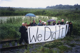
Item is a photograph of 12 people holding a sign that says "We Did It!", referring to the designation of the island as a regional park. "Alouette Field Naturalists" is written on the back of the photograph.
Maitland & Maitland [Copy of a composite panoramic photograph of a sawmill site]
Part of Stuart Thomson fonds
Maitland & Maitland [Copy of aerial photograph of mill site]
Part of Stuart Thomson fonds
![[Photograph of drawing for a theatre : job no. 212]](/uploads/r/null/7/e/7e7dba39c319cff0d41b44ff82cdf1c0e6897ee471cd3c96cacc23b036440dfb/b7c7957f-5200-4940-beac-df81de36fa58-A39829_142.jpg)
[Photograph of drawing for a theatre : job no. 212]
Photograph shows architectural perspective drawing of a theatre intended for the corner of Broadway and Granville St., Vancouver B.C.
Union Steamships Ltd. - aerial views - B.C. coast ports of call
Album contains professionally taken oblique-perspective photographs of the following ports-of-call along the B.C. coast: Alert Bay, Bowen Island, Bella Bella, Blind Channel, Blubber Bay, Bold Point - Quadra Island, Boswell Inlet, Britannia Beach, Brunswick Cannery, Butedale, Cape Caution, Campbell River, Carlisle Cannery, Church House, Claxton Cannery, Digby Island, Fairview Point - Kaien Island, Gibsons Landing, Granite Bay - Quadra Island, Granthams Landing, Halfmoon Bay, Heriot Bay - Quadra Island, Hidden Inlet Cannery, Hopkins Landing, Jap Inlet (later Hunt's Inlet) - Portier Island, Irvines Landing, Long Bay, Lund, Margaret Bay, New Brighton, Oceanic, Pitt Island, Porteau, Port Alexander, Port Belmont, Port Chester, Port Edward, Port Essington, Port Graves - Gambier Island, Port Irving, Port Neville, Port Simpson, Port Walter, Powell River, Prince Rupert, Roberts Creek, Quathiaski Cove, Redonda Bay, Rivers Inlet, Savary Island, Sechelt, Selma Park, Squamish, Squirrel Cove, Stillwater, Sunnyside Cannery, Swanson Bay, Tamagast Harbour, Topaz Harbour, Vananda, Wadhams, Woodfibre; and Alaska: Ketchikan, Metlakalta, Petersburg, Wrangell. Includes views of canneries, mining towns, Native villages, sawmills, pulp and paper mills, etc.
Union Steamships Ltd. - Photo Record - No. 2
Album contains photographs by professional photographers Ballentine and J. Weston of scenes along steamship routes. Locations include Alert Bay (B.C. Packers Store), Britannia Beach, Butedale, Telegraph Cove, and other unidentified coastal communities. Also shown are fishing and fish processing by Asian, European-Canadian, and Native workers. Other shots include cargo, scenic views, ship exteriors, and scenes of passengers aboard ship.
![[Photograph of B.C. Housing Foundation, senior citizens home, 2955 Horsley St., Vancouver B.C.]](/uploads/r/null/3/2/329f023049f56fed91835cd2a3aa65a3d5f6ea62cac9badceb6a2ebc28f2014d/dc6f107f-cf3b-49c4-b1fe-7d916ebe68e6-A39130_142.jpg)
[Photograph of B.C. Housing Foundation, senior citizens home, 2955 Horsley St., Vancouver B.C.]
![[Photograph of unidentified house]](/uploads/r/null/c/3/c35ead2fdfbeefdda334e75656c550b50876c0d79f1751d53c4533143160eef9/c0046fab-dca5-4820-9c00-ff04b900609d-A39129_142.jpg)
![[Unidentified house]](/uploads/r/null/a/5/a5423756c99c2f6642c76da5c4dece9fd697322215a6f5a4e0c09ac6cbd4b151/bb12afe0-26af-4436-bc19-85a8ddad5ea8-A39124_142.jpg)
Photograph shows living room
![[Floating village from a ship]](/uploads/r/null/b/d/d/bdd8b871ae47efbd8809e7d515330aa97593f31f39bf76bb48bffd6fd23a6cb8/70281e6e-4000-413e-96fb-96e82f0679f0-CVA374-244_142.jpg)
[Floating village from a ship]
![[Floating village]](/uploads/r/null/3/4/6/346db92a826881787c29170756174220783e5796c1b2ed6ea90b9cfb7c31bbe6/d1cc1aac-5757-49f6-ba2d-427bc7d7a162-CVA374-245_142.jpg)
![[Howe Sound Ferries Ltd. Dispatcher's Office and Coffee Shop building at unidentified beach]](/uploads/r/null/0/d/1/0d1cc96cd976634087da4cedf8dcf4fce664751681e91f73b61b02fde6e094cb/7d85fce0-0a3d-47a0-be76-528890f58e0a-CVA374-362_142.jpg)
[Howe Sound Ferries Ltd. Dispatcher's Office and Coffee Shop building at unidentified beach]
![[Interior of wheel house on S.S. "Catala"]](/uploads/r/null/3/8/1/381e23111d52d0cb905cc02cce1414cbe2a1030d01db4a2f7441498ded909908/37678dab-2c6a-4e4d-aa54-42e88e71a8e5-CVA374-168_142.jpg)
[Interior of wheel house on S.S. "Catala"]
![[S.S. "Catala"]](/uploads/r/null/e/0/8/e0899a4926c2c1bbbb673a97636414caddb85881ad685b762b0ef3606ab102aa/0bec7baa-b3cd-4246-aaee-59a26e52a2bd-CVA374-24_142.jpg)
![[S.S. "Chilliwack" (II) at dock]](/uploads/r/null/2/6/f/26fbbe63d9ef32214d1a82f62eb3f47a4d3512f37f01fe1c6f5c586d8a7cbc22/fd5f1a0a-3397-4c7e-ad66-9d3e6b66080c-CVA374-56_142.jpg)
[S.S. "Chilliwack" (II) at dock]
![[S.S. "Lady Alexandra"]](/uploads/r/null/7/4/e/74e87d22579d72c80b76610fb6a3083e0a77f35f8abf9edcf8901caa3937305e/0a29283e-c0ae-465f-b3c8-bc4c0e86379a-CVA374-95_142.jpg)
Oblique view
![[Upper passenger deck of either "Lady Cecilia" or "Lady Cynthia"]](/uploads/r/null/6/1/9/6196afdfb81937783e4b2caf72226df6616f2e1bf93bb8ed0462b87a37014750/7f89ce80-349d-416a-a8cd-cec4117488e0-CVA374-171_142.jpg)
[Upper passenger deck of either "Lady Cecilia" or "Lady Cynthia"]
![[View of unidentified resort area of Union Estates]](/uploads/r/null/2/e/0/2e03d30a9532a7b59f9a1bda0974b8db763508548579941882dfdb890041945c/79411a1f-303e-4bdb-af29-0eba3f6b9c08-CVA374-481_142.jpg)
[View of unidentified resort area of Union Estates]
![[Warship viewed from Coastal Steamer in] Queen Charlotte Strait B.C.](/uploads/r/null/d/1/a/d1a1232ec7f3649e597ad3c1110b0bbe7369aa213f8eedf71ee4c46d894741c2/bf0dddb3-0ed7-431a-9992-13dc39ec2e82-CVA374-246_142.jpg)
[Warship viewed from Coastal Steamer in] Queen Charlotte Strait B.C.
![Board of Trade Excursion on the P.G.E. [Pacific Great Eastern]](/uploads/r/null/2/5/3/253028f0a7e19caad09c12892abc302244da74b1727bbe629f8a06f25aab06e1/423124a8-95b4-465b-906c-b251c0063524-CVA374-186_142.jpg)
Board of Trade Excursion on the P.G.E. [Pacific Great Eastern]


Photograph shows a view looking south from deck of S.S. "Coquitlam"


Map no. 2 shewing Union Steamship Company route and ports of call : northern run
Item is a map showing ports of call along Haida Gwaii (Queen Charlotte Islands) and the northern coast of British Columbia from Stewart to Smith Sound.

Item is a map showing cities and towns, smaller settlements, post offices, railways, roadways, trading posts, ferries, hospitals, telegraph lines, government agents' offices, mining and sub-mining recording offices, falls and rapids, drainage flow, and park, provincial, and international boundaries. An inset map shows the southern Vancouver Island and Lower Mainland area in greater detail. Item includes road, rail, and coastal distance tables, lists of administrative offices and their locations, and an index of post offices.

Chinese Winter Quarters near North Bend, B.C.
Part of Major Matthews collection

Coal Creek B.C. looking toward Fernie
Part of Major Matthews collection

Crossing Fraser River by Cable near Yale
Part of Major Matthews collection
Part of Major Matthews collection
Photograph shows a woman on a bridge

Effects of Snow Slide, Rogers Pass
Part of Major Matthews collection
Photograph shows a C.P.R. train buried in snow

Felling the Timber, Royal City Mills Camp
Part of Major Matthews collection
![Floods 1894 [showing a] Ranch on the Fraser [River]](/uploads/r/null/b/c/bc3c28ed13446cf1252323e0a705451fc3881e882a13928ed2398a79e9562415/e7d527bb-0f71-47d9-b399-52b4ec995022-A33077_142.jpg)
Floods 1894 [showing a] Ranch on the Fraser [River]
Part of Major Matthews collection

Part of Major Matthews collection

Fraser River, 4 miles below Lytton
Part of Major Matthews collection

Part of Major Matthews collection
Photograph shows a river running through a canyon

Part of Major Matthews collection

Glacier cascade. Summit of Selkirks
Part of Major Matthews collection

Part of Major Matthews collection
![Harrison [River flood]](/uploads/r/null/e/7/e7e8221ae477cb44cccb068dd6aeca6b37be6c20182d659cbef886ad14593b9c/480e6c13-3fcc-4887-8b70-0341237bc377-A33074_142.jpg)
Part of Major Matthews collection
![[View of section of electrical tower]](/uploads/r/null/8/7/87a0751780d16abfddccbcc8b91ff787f677b670bf225aea7ecb8f10fdce4e04/03158521-2c84-4cfa-9445-d14799869084-A04750_142.jpg)
[View of section of electrical tower]
Part of Major Matthews collection
![[View of the Asulkan Glacier in the Selkirks]](/uploads/r/null/1/f/1f7dc99041b4a4bf3dc6672023ebe99c12d44ceedc2e036d96b555fb38aa3d7e/43d6a7b9-d991-43c8-a2cf-1576cdfef382-A33088_142.jpg)
[View of the Asulkan Glacier in the Selkirks]
Part of Major Matthews collection
![[View of the entrance to Princess Louisa Inlet]](/uploads/r/null/1/4/14010d532ba587a29e79e7b835278f8ed0e3ed0d82b1f50147a97d7c012b034a/a643a0d7-57f0-48d5-9cec-0da01541a9fe-A33232_142.jpg)
[View of the entrance to Princess Louisa Inlet]
Part of Major Matthews collection
![[View of the Fraser River and Hope Mountain]](/uploads/r/null/2/b/2b2b39eaeb5e45208b13e02bd5e8574cea233047ebebbe08b8e85d258da6a469/a09129e9-56fe-44c1-9b3d-dd9af1ef3612-A31717_142.jpg)
[View of the Fraser River and Hope Mountain]
Part of Major Matthews collection
![[View of the Marpole rail and highway bridges]](/uploads/r/null/3/9/39d081635b9fd32192951910755276ab7921e8ca55e3206da51189c0b65a8080/015c04a5-11d7-4d15-95ab-e794ef8e9f32-A24442_142.jpg)
[View of the Marpole rail and highway bridges]
Part of Major Matthews collection
Oblique view shows Vancouver International Airport.
![[View of the Oak Street, B.C. Electric and Middle Arm bridges]](/uploads/r/null/8/d/8d4f4dea792a3128229aecfd55a12d3a3432476462ad8cd9991e1ebb16cae075/62c52137-d9af-48bd-a8bc-2a12293b382d-A24441_142.jpg)
[View of the Oak Street, B.C. Electric and Middle Arm bridges]
Part of Major Matthews collection
oblique view
![[View of the Thompson River east of Lytton]](/uploads/r/null/b/5/b57bdc9554f4c089b187d1c5f5b233acbf931272e64dad2a0b54dd28040149cf/21978601-2e31-4d42-983f-3d601c619e55-A33843_142.jpg)
[View of the Thompson River east of Lytton]
Part of Major Matthews collection
![[View of Vermillion River in Kootenay National Park]](/uploads/r/null/c/8/c8c364673e8a2c868a3312f032dd999c535c7afcb0dbe8035ae094b950e597c1/5a6c5f94-1058-4309-8353-804ffaa118f1-A34133_142.jpg)
[View of Vermillion River in Kootenay National Park]
Part of Major Matthews collection
![[Wigwam Inn]](/uploads/r/null/f/9/f97ee4ea4b2bbbaedcdfd4eaa13a4121ccb70e3147327ec84568b01d9bd1ab7c/7e28c8c2-058c-4689-86ef-cc3c03170f9d-A04432_142.jpg)
Part of Major Matthews collection
J.S. Matthews' notes with print or negative in Archives.
Part of Neil Gilchrist fonds
Item is a photograph album showing various scenes of family, friends, classmates, school events, Provincial Normal School boys' and girls' basketball teams, leisure activities, Labour Day parades; geographic areas include around Vancouver and the lower mainland including English Bay and Second Beach, as well as various locations from around the province such as Victoria, Buccaneer Bay, Armstrong, Vernon, Harrison and other sites. The album also includes photographs showing ships and soldiers in uniform from World War I, including Witley Camp, England and Signal Hill in Esquimalt, B.C., including portraits and group photographs.