![[Gastown street view, 1 of 3]](/uploads/r/null/6/2/f/62f6b6df00ce52d3d087dc37b03f96dd42bb02132b1f38b897fe96a2c73635f9/831e67ee-6529-4c45-81a3-a8e5f729ec5d-CVA1095-04391_142.jpg)
- COV-S644-: CVA 1095-04391
- Item
- Feb.- Mar. 1974
Part of City of Vancouver fonds
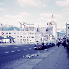
Item is a photograph that depicts a street view in Gastown. The business sign for Wisconsin Engines Distributor is visible.
Part of City of Vancouver fonds
Item is a photograph that depicts a street view in Gastown. The business sign for Wisconsin Engines Distributor is visible.
![[Gastown street view, 2 of 3]](/uploads/r/null/1/3/b/13b6abba442b7ad968d1644164754126e4219bc38926b8509497e7ed5f15882d/0ee9437a-541a-4469-abdb-aba8ed695c7f-CVA1095-04392_142.jpg)
Part of City of Vancouver fonds
Item is a photograph that depicts a street view in Gastown. The business sign for Wisconsin Engines Distributor is visible.
![[Gastown street view, 3 of 3]](/uploads/r/null/f/9/5/f9587f6dd89a2e70330cc88f41f3d896877321e7aed061a9fdab174b866e6a3a/2c2ff0d3-7ba0-4aec-9371-ce4b83084a0e-CVA1095-04408_142.jpg)
Part of City of Vancouver fonds
Item is a photograph that depicts a street view in Gastown. The business sign for Wisconsin Engines Distributor is visible.

![[Granville Street and Dunsmuir Street intersection]](/uploads/r/null/d/c/7/dc7cf8d38a9d5465b80d347fdf86bcd09f64652a0cb80b81baee0c420c9cf91c/ebbadfbb-0b8b-45eb-8cf5-ed9852ceef6b-CVA1095-12591_142.jpg)
[Granville Street and Dunsmuir Street intersection]
Part of City of Vancouver fonds
![[Granville Street and West Pender Street intersection]](/uploads/r/null/2/c/7/2c7c92b8459603990d96ee07885cf71056d2ea8ea542e01a4bdfa4f4c4150037/b5c47fd5-252f-4f07-b238-5dc6ba10f504-CVA1095-12584_142.jpg)
[Granville Street and West Pender Street intersection]
Part of City of Vancouver fonds
![[Granville Street and West Pender Street intersection - The Toronto Dominion Bank]](/uploads/r/null/4/3/5/435ea6c1527a7ca0b41c9b75c282b23adaf17be012a73db919071d6480a2ad65/6653ad06-c557-4549-9a25-b8b6126b546b-CVA1095-12634_142.jpg)
[Granville Street and West Pender Street intersection - The Toronto Dominion Bank]
Part of City of Vancouver fonds
![Hastings Street, South Granville, Chinatown [Garbage can]](/uploads/r/null/c/2/6/c2623f5d0d998afec80a36837f14156b22abf8dd453a893835f7b2aee7855d8f/a6b61680-7698-49bd-81e4-3364a0bcdb30-CVA1095-08727_142.jpg)
Hastings Street, South Granville, Chinatown [Garbage can]
Part of City of Vancouver fonds
![Hastings Street, South Granville, Chinatown [Mailbox]](/uploads/r/null/0/a/2/0a2b0f69cad5632f5941631085c841b316940b9f0f608b39ae1fb6ce407a45a5/33cdb7b6-a852-4ceb-af0d-2871ab7358e0-CVA1095-08728_142.jpg)
Hastings Street, South Granville, Chinatown [Mailbox]
Part of City of Vancouver fonds
![[Image of printed photograph - "View of Granville Street"]](/uploads/r/null/9/d/6/9d6c637a37121f031ea60746db7753427389b2bb73a30e1b3af062285082579a/05794931-753d-47af-b9f6-4af388f60ef5-CVA1095-06552_142.jpg)
[Image of printed photograph - "View of Granville Street"]
Part of City of Vancouver fonds
Item is a photograph of a journal article from The Architect, Builder and Engineer.
![[Image of printed photograph - "View of Hastings Street"]](/uploads/r/null/d/2/a/d2afcec311f0dc7d1d24e64ec192dc79e208076b1387b180aa875e4838389eff/b2fd158f-139d-47c2-9df6-6d2e1cf5d6b7-CVA1095-06551_142.jpg)
[Image of printed photograph - "View of Hastings Street"]
Part of City of Vancouver fonds
Item is a photograph of a journal article from The Architect, Builder and Engineer.

Intersection at West Hastings and Burrard Streets
Part of Leopold Bentley family fonds
![[Intersection of Main Street at East Hastings Street]](/uploads/r/null/8/c/9/8c9c7bb8aa0cba8f5089f503550bb26888f3d98816adaf153ef449ebd1b20502/13030bb6-ecd4-4fd1-b9cb-30da3525452f-CVA1095-06902_142.jpg)
[Intersection of Main Street at East Hastings Street]
Part of City of Vancouver fonds
![[Intersection of Seymour Street and Robson Street]](/uploads/r/null/3/e/d/3edc21bd849ad2b68b7a589c59b6b8da54190e386b630cb9a38b15a88c640c0d/cf09cf8b-a63f-42ee-bfab-f157d21c1b8a-CVA1095-07127_142.jpg)
[Intersection of Seymour Street and Robson Street]
Part of City of Vancouver fonds
Item is a photograph that depicts the intersection of Seymour and Robson St. Visible is the business sign for Beau Brummell Boutique.
Looking north from Bowell-McLean Motor Co. Ltd. at 615 Burrard Street
Part of Leopold Bentley family fonds

Map of down-town retail business section
Part of City of Vancouver Archives technical and cartographic drawing collection
Part contains a map of downtown Vancouver showing streets and businesses, and information on industry in Vancouver and British Columbia.

Map of downtown section of Vancouver ; Diagram of New Westminster, B.C., downtown section
Part of City of Vancouver Archives technical and cartographic drawing collection
Part contains road maps of downtown Vancouver and New Westminster, and textual information for tourists and motorists.

Part of City of Vancouver Archives technical and cartographic drawing collection
Part contains a street map of downtown Vancouver, a street map of Vancouver and the Fraser Valley, detail maps showing traffic interchanges corresponding to numbers on the Fraser Valley map, and general tourist information.
![Miscellaneous [42 of 130]](/uploads/r/null/a/f/af44f9354a84840abfd83f918936890c7c156600112573e3ef22bbc5cc047ca9/0d79d306-dfc4-4932-af34-a5254784f375-A64368_142.jpg)
Part of City of Vancouver fonds
Item is a photograph showing Robson Street between Burrard and Bute.
![[North east corner of the intersection of Carrall Street and East Hastings Street]](/uploads/r/null/e/0/1/e019a829f19e3f6e8cd130b4b8b3ac38f605b825aed40c726e1f12669b50b379/eafab0c9-428d-4039-83c2-71c770cfb297-CVA1095-06735_142.jpg)
[North east corner of the intersection of Carrall Street and East Hastings Street]
Part of City of Vancouver fonds
Item is a photograph that depicts the intersection of Carrall St. and East Hastings St. Visible is the business sign for Hastings Cigar Store.
![[North east corner of the intersection of Carrall Street and East Pender Street, 1 of 2]](/uploads/r/null/9/e/8/9e80f0911186d18dd8f71c0c130361e20f6207aed6d564dfea6829ad53483f2d/de5f0a76-2d9b-4477-8072-3a95375e7bc4-CVA1095-06753_142.jpg)
[North east corner of the intersection of Carrall Street and East Pender Street, 1 of 2]
Part of City of Vancouver fonds
Item is a photograph that depicts the intersection of Carrall St. and East Pender St. Visible is the business sign for Chinese Times.
![[North east corner of the intersection of Carrall Street and East Pender Street, 2 of 2]](/uploads/r/null/3/6/e/36e68ec75ab0fb5898944d239fc6d74f7a8d1424a7c038f1ae2d5610a287b04f/51ee0da4-c395-46c0-86bf-7d58e7bd648e-CVA1095-06754_142.jpg)
[North east corner of the intersection of Carrall Street and East Pender Street, 2 of 2]
Part of City of Vancouver fonds
Item is a photograph that depicts the intersection of Carrall St. and East Pender St. Visible is the business sign for Chinese Times.
![[North view of Carrall Street from Water Street, 1 of 2]](/uploads/r/null/7/c/4/7c4a7e2a1e5e1c6bae4d14cefa8561af2ad41ce1c271d1088eb81894204e2b7f/b15bd9d2-ae7b-49a6-adb8-d711949e8d37-CVA1095-06619_142.jpg)
[North view of Carrall Street from Water Street, 1 of 2]
Part of City of Vancouver fonds
![[North view of Carrall Street from Water Street, 2 of 2]](/uploads/r/null/b/3/a/b3ad597df5851530900e1d06751fd4e00ccb978a469604da9640ac6872982097/4cee2d1c-19c9-4f84-a02b-0952de97cf8a-CVA1095-06620_142.jpg)
[North view of Carrall Street from Water Street, 2 of 2]
Part of City of Vancouver fonds
![[Northeast corner of the intersection of East Cordova Street and Columbia Street]](/uploads/r/null/d/7/9/d792788efa2b7ec21c7afc5aa249966b29094be589f9b0399b4204426aa50af5/1524bfb2-14f1-410b-bbb1-ef08d2040fbc-CVA1095-07742_142.jpg)
[Northeast corner of the intersection of East Cordova Street and Columbia Street]
Part of City of Vancouver fonds
![[Northeast corner of the intersection of Water Street at Abbot Street]](/uploads/r/null/2/8/9/289c3350b1d48e368ef090bc5540715bc7d4e73a017277e886fd56f802967730/1b1af69b-cabb-4100-a93e-c1b07d77af86-CVA1095-06592_142.jpg)
[Northeast corner of the intersection of Water Street at Abbot Street]
Part of City of Vancouver fonds
![[Northwest corner of the intersection of Main Street at East Hastings Street]](/uploads/r/null/d/c/b/dcbe2f1d4fc7b47719e5182cadf9c0b244501f6c1ec4d05583545b5d1630f3e3/8f7ac7d6-bc39-4893-9f16-4cebff5ba7fa-CVA1095-06901_142.jpg)
[Northwest corner of the intersection of Main Street at East Hastings Street]
Part of City of Vancouver fonds
Item is a photograph that depicts the intersection of Main and East Hastings Streets. Visible are the business signs for Dominion Bank, The Barr's house of Good Food, and Grace Mission.
![[Northwest corner of the intersection of Seymour and Robson Street]](/uploads/r/null/c/6/1/c61039510b4e320b2a7b0a070b98a8652b635c8f177f5ddc50108261adf04bb2/38707ec2-56e7-491a-8317-4a68614e7a36-CVA1095-07130_142.jpg)
[Northwest corner of the intersection of Seymour and Robson Street]
Part of City of Vancouver fonds
Item is a photograph that depicts the intersection of Seymour and Robson St. Visible is the business sign for Beau Brummell Boutique and the top of the Birks Building.
![[Pedestrian crossing at intersection of West Hastings Street and Abbott Street]](/uploads/r/null/1/0/5/1051b63b6eab407ebf79d72c119a020fd2ff82f9547d358161350ae5e50abf3c/b35c8d17-d4cb-492d-a0c3-91057ab14602-CVA1095-08366_142.jpg)
[Pedestrian crossing at intersection of West Hastings Street and Abbott Street]
Part of City of Vancouver fonds
Item is a photograph that shows the northeast corner of West Hastings St. and Abbott St. Visible is the Field's Department Store business sign.
![[South east corner of the intersection of Carrall Street and East Hastings Street]](/uploads/r/null/4/9/b/49b5325cd04963ca4872e2d71d8ae973d9c9d7d9de8423b6c3c21716aa2ecc1f/528bb0cc-0234-42c3-a77b-465d00512ab2-CVA1095-06738_142.jpg)
[South east corner of the intersection of Carrall Street and East Hastings Street]
Part of City of Vancouver fonds
Item is a photograph that depicts the intersection of Carrall St. and East Hastings St. Visible is the business sign for Roger Hotel.
![[South view down Carrall Street from Water Street, 1 of 2]](/uploads/r/null/b/9/9/b999da6f8b5df0d848df6f5add43a5872f151879659c5a96d20c886f969e046d/37ab7642-6346-4e37-9493-e1941e178b3d-CVA1095-06661_142.jpg)
[South view down Carrall Street from Water Street, 1 of 2]
Part of City of Vancouver fonds
![[South view down Carrall Street from Water Street, 2 of 2]](/uploads/r/null/e/b/a/eba713dde9faf2b150da399a83815ff2d6a02eae37f33544e1667f48faf3227c/cab73cc6-d55b-4f09-a870-718c1ab2bac1-CVA1095-06662_142.jpg)
[South view down Carrall Street from Water Street, 2 of 2]
Part of City of Vancouver fonds
![[South view down Main Street from East Hastings Street]](/uploads/r/null/4/d/a/4da0e540b52ac7e6ee28d8e440ab40b8ed6368ad62e8b05016be74c45a35ffb3/f98e948d-29fd-4539-8b19-c96762b87598-CVA1095-06900_142.jpg)
[South view down Main Street from East Hastings Street]
Part of City of Vancouver fonds
![[Southwest corner of Granville Street at intersection with Robson Street]](/uploads/r/null/7/e/0/7e04f32d9cbb48ce427e11c992251a95c3571d08860c026133cb4f9001f61579/3a6ef007-027f-4851-ad80-1e15d8d1b14a-CVA1095-00922_142.jpg)
[Southwest corner of Granville Street at intersection with Robson Street]
Part of City of Vancouver fonds
Item is a photograph that depicts a southwest view of Granville Street taken from the intersection at Robson Street. Visible is the marquee for the Coronet Theatre (851 Granville Street), Mr. Jakes Charbroiled Steaks (831 Granville Street), and the Canadian Bank of Commerce (819 Granville Street).
![[Southwest corner of the intersection of Carrall Street and West Hastings Street]](/uploads/r/null/1/3/9/139d5c1b98f2d56552c70dce141980795a355369c2aa5c7d602a9292b952523a/d5dfc202-b096-44b6-a4ed-b82bb4605701-CVA1095-06803_142.jpg)
[Southwest corner of the intersection of Carrall Street and West Hastings Street]
Part of City of Vancouver fonds
![[Southwest corner of the intersection of West Cordova and Carrall Streets]](/uploads/r/null/b/5/e/b5ee5acb102bf07c706ee2a29f35a7442cc8b3a9a127af18f433f96867c76d9e/5fbe1b1f-24a3-47fd-8c24-7abe6b7b4c70-CVA1095-06822_142.jpg)
[Southwest corner of the intersection of West Cordova and Carrall Streets]
Part of City of Vancouver fonds
![[Southwest corner of Water Street at Carrall Street, 1 of 2]](/uploads/r/null/d/d/f/ddfb82bb5b4f37b4ad459eb45ee5211da21aa8f0db2718a13b3f66740d5a05f0/629cb31c-9ae5-40dd-8d1a-169ed9aa68a0-CVA1095-06855_142.jpg)
[Southwest corner of Water Street at Carrall Street, 1 of 2]
Part of City of Vancouver fonds
Item is a photograph that depicts the intersection of Water Street at Carrall Street. Visible is the Bynes Block at 2-8 Water Street.
![[Southwest corner of Water Street at Carrall Street, 2 of 2]](/uploads/r/null/f/a/3/fa3a8551ec886f76323d5543200d094b50f49d9d822e9e7971c042b372bcfff1/c427b128-a627-4646-9412-ee66e80a4d59-CVA1095-06856_142.jpg)
[Southwest corner of Water Street at Carrall Street, 2 of 2]
Part of City of Vancouver fonds
Item is a photograph that depicts the intersection of Water Street at Carrall Street. Visible is the Bynes Block at 2-8 Water Street.
![[The south side of Robson Street looking east from Howe Street]](/uploads/r/null/b/8/b84edd704cfd8a61489db059b40092b4ca3b60410ee2edbd7e10f0733ff2a570/07aa5c1e-c742-4cfd-a986-21739fa5b793-A37176_142.jpg)
[The south side of Robson Street looking east from Howe Street]
Part of Major Matthews collection

Topographic map of Downtown Vancouver and the East End
Part of City of Vancouver fonds
Item is a map showing two sets of topographic contour lines, streets, and block numbers (in Roman numerals) in the area from Robson Street to Raymur Avenue and Coal Harbour/Vancouver Harbour to False Creek.

Transit detail inset maps ; Street index ; Transit and tourist information
Part consists of three maps showing transit details in Richmond, New Westminster and downtown Vancouver, and descriptive information about B.C. Electric routes and services and Greater Vancouver attractions.

Vest pocket map of Vancouver : map A
Part of City of Vancouver Archives technical and cartographic drawing collection
Part contains a key plan for the larger maps, textual information about Vancouver, and a map of the West End and downtown Vancouver.
![[View down 300 block of Water Street]](/uploads/r/null/4/6/9/469edabe28790deb17123eec4a5ef2d6db75e741c49ecfb03bdb6fe1a4317376/e4bf0a27-c2af-404d-b61b-29ceb4ca9e82-CVA1095-08093_142.jpg)
[View down 300 block of Water Street]
Part of City of Vancouver fonds
Item is a photograph that depicts a view of the north side of the 300 block of Water Street. Visible are the business signs for the Mexicorner Restaurant (199 Water Street) and Gastown Fabric Bin (162-170 Water Street).
![[View down southeast side of Abbott Street from intersection at Water Street]](/uploads/r/null/4/f/7/4f74f1bdd2807a272530fb1fa2912a597ca53c69fb4060f051e408d4f4aad384/80fee93c-734e-4741-8a55-b6a54c9eb598-CVA1095-08382_142.jpg)
[View down southeast side of Abbott Street from intersection at Water Street]
Part of City of Vancouver fonds
Item is a photograph that depicts a view of the east side of the 200 block of Abbott Street. Visible is the Dominion Hotel (210-216 Abbott Street).
![[View east down 0 block East Pender Street]](/uploads/r/null/1/3/5/1354e9ed875562afbad5173bd2897d4e8aad8517ffccbbc1ee8e822b75d61565/82bac4a0-0340-4e7d-b952-0f1e38710a71-CVA1095-08314_142.jpg)
[View east down 0 block East Pender Street]
Part of City of Vancouver fonds
Item is a photographs a view east down East Pender Street. Visible are the business sign for Ming Wo Cookware.
![[View east down 00 block of Water Street]](/uploads/r/null/3/9/5/3950b1d312c7a20d5228e0ba77297abee1d6a420c57f2249d33bada479719dae/00cd5ad5-009a-4a74-a3a3-c43b41cf5991-CVA1095-07920_142.jpg)
[View east down 00 block of Water Street]
Part of City of Vancouver fonds
Item is a photograph that depicts a view east down Water Street. Visible are the Deighton House and Universal Handcrafts (110-112 Water Street) , Barkerville Inn Restaurant (102-108 Water Street), Dominion Hotel (210-216 Abbott Street) and Hotel Europe (43 Powell Street).
![[View east down 00 (unit) block of Water Street]](/uploads/r/null/5/7/b/57bbfe8c9dba8be9e744048e63ee0b624cd0bff5d1861edfea0ce326bce2132b/319b3400-f0f0-49b2-8083-48c6e50c7cad-CVA1095-08133_142.jpg)
[View east down 00 (unit) block of Water Street]
Part of City of Vancouver fonds
Item is a photograph that depicts a view east down the 00 (unit) block of Water Street. Visible are the business signs for Trident Imports Ltd. (57 Water Street), FlexSteel (68 Water Street), and the Town Pump Restaurant Cabaret (66 Water Street). Also visible in the background is the Europe Hotel (43 Powell Street).
![[View east down 100 block of East Hastings Street]](/uploads/r/null/c/5/2/c527659318b3373f40b0ca496e5ce9bdbefdb74f723756e092c0637c0d8d0279/83bee2a1-6044-4c09-adf4-ab1a755566a8-CVA1095-06910_142.jpg)
[View east down 100 block of East Hastings Street]
Part of City of Vancouver fonds
Item is a photograph that depicts the 100 block of East Hastings Street. Visible are the Balmoral Hotel (159 East Hastings) and Regent Hotel (160 East Hastings), and Dawson Block (193 East Hastings) .
![[View east down East Hastings Street from Main Street]](/uploads/r/null/9/f/b/9fb931c8f96acb371bd259e38cf9f3004333fffb078e8c777c6b18832dce192c/cf5fb502-2c87-4430-94fe-e90e3f4fc4e2-CVA1095-06898_142.jpg)
[View east down East Hastings Street from Main Street]
Part of City of Vancouver fonds
Item is a photograph that depicts the intersection of Main and East Hastings Streets. Visible are the business signs for Hotel Savoy, Safeway, and Army and Navy.
![[View east down East Hastings Street from the intersection at Main Street]](/uploads/r/null/1/b/7/1b7dded9ef2d9037e14b2f77adcd8fe7d3ca3d8de2c66719baa14f43bcf96457/32d983b9-6294-4de7-9ccc-3ea3a54d851a-CVA1095-06908_142.jpg)
[View east down East Hastings Street from the intersection at Main Street]
Part of City of Vancouver fonds