Aerial view of Pacific Terminal showing grain elevators and shipping containers in Vancouver Harbour
Aerial view of Pacific Terminal showing grain elevators and shipping containers in Vancouver Harbour
Aerial view of Pacific Terminal showing grain elevators and shipping containers in Vancouver Harbour
Aerial view of Pacific Terminal showing grain elevators and shipping containers in Vancouver Harbour
Aerial view of downtown Vancouver
Aerial view of downtown Vancouver

Black and white (grainy) pre-1937

Jan 1985 : Angles

Jan 1985 : Angles
Jan 1985 : Angles

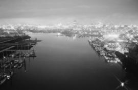
Aerial view of False Creek
Aerial view of False Creek

Aerial view of False Creek
Aerial of Vancouver, B.C.
Aerial of Vancouver, B.C.
Aerial shot of the West End from over English Bay with Denman Street meeting Beach Avenue near the Old Boat House
Aerial shot of the West End from over English Bay with Denman Street meeting Beach Avenue near the Old Boat House
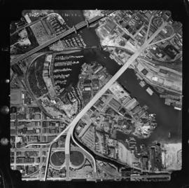
Summer 1982 - Aerial shot from the south side of False Creek before Expo
Summer 1982 - Aerial shot from the south side of False Creek before Expo
Aerial of Vancouver, B.C. [over False Creek]
Aerial of Vancouver, B.C. [over False Creek]
Aerial shot from over Stanley Park
Aerial shot from over Stanley Park
Gibsons B.C.

Gibsons B.C.

Lower New York from an aeroplane

Aeroplane view of Vancouver, B.C., Canada : Royal Canadian Air Force photograph

Vancouver, B.C., Canada : aerial view of Downtown Vancouver, Burrard Inlet and the North Shore Mountains
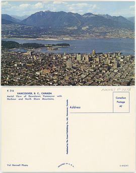
Vancouver, B.C., Canada : Aerial view of Downtown Vancouver with harbour and North Shore Mountains

Vancouver, B.C., Canada : West End and park - looking west to Point Atkinson

Vancouver, B.C., Canada : aerial view of downtown Vancouver, Burrard Inlet and North Shore Mountains
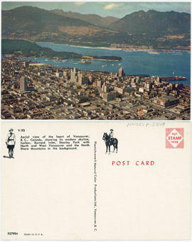
Aerial view of the heart of Vancouver, B.C., Canada

Vancouver, B.C., Canada
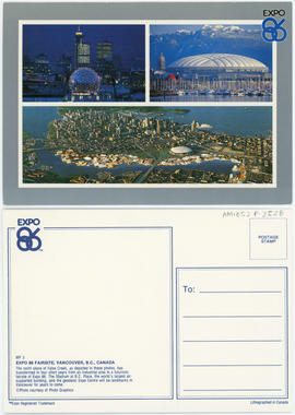
Expo 86 Fairsite, Vancouver, B.C., Canada

Expo 86 Fairsite, Vancouver, B.C., Canada

Expo 86, Vancouver, B.C., Canada

Aerial view of passenger ship entering the Narrows, Vancouver, B.C.

Aeroplane view of English Bay & the West End of Vancouver, B.C.

Aerial view of swimming pool, Kitsilano Beach, Vancouver, B.C.

Vaucroft Beach from the air
![Vancouver looking east from [Howe Sound]](/uploads/r/null/6/6/66fa4a6e8bb1ab5d20d8f951fa93ad57dd828be645aff6d182d88a8b36c69281/69bee6e1-54a6-4c8f-a7db-043e03b4dfe6-A23503_142.jpg)
Vancouver looking east from [Howe Sound]
![[Oblique view of downtown Vancouver in a north-west direction]](/uploads/r/null/5/c/5c03a395bbea3b7e6213c020856ebb51189ab9fa777b740bd771f4671d063162/541995be-d078-4a39-a750-27e3dd7e40f2-A23506_142.jpg)
[Oblique view of downtown Vancouver in a north-west direction]
![[Aerial view of] Pacific National Exhitibiton [at Hastings Park]](/uploads/r/null/a/1/a116a8e45ea6a44bdb7ba392de0b1b8efb36141a922d86476cb445f3e655d728/e966525e-2606-4380-8c22-e5a629d846e9-A23507_142.jpg)
[Aerial view of] Pacific National Exhitibiton [at Hastings Park]
![[Aerial view of the University of British Columbia campus]](/uploads/r/null/3/b/3b26ad7abfb1609951345f3da59b98d3acb9e35f6e934378ca7fe7b7f51bc1d6/60118a86-5a6f-4ba9-b3b3-f32583aabd22-A23508_142.jpg)
[Aerial view of the University of British Columbia campus]
![[Aerial view of] Stanley Park Vancouver BC [with] Second Beach Swimming Pool in the foreground.](/uploads/r/null/a/1/a15c959fdf22a475acde3dfbe34911d2ed0e908b82a181e788f415ac76b8aa42/60444948-c365-41d2-8860-876a49aa0885-A23509_142.jpg)
[Aerial view of] Stanley Park Vancouver BC [with] Second Beach Swimming Pool in the foreground.
![[Aerial view of] Vancouver B.C. looking east from English Bay](/uploads/r/null/0/3/03edb95dfe9ca891ff17aa9561a8ca736b17e0997af5e4e0c00c4fbce5babe44/9e1c7ace-8758-4763-a19f-d85080d23dbe-A23510_142.jpg)
[Aerial view of] Vancouver B.C. looking east from English Bay
![[Aerial view looking south-east from Georgia and Richards Streets]](/uploads/r/null/6/c/6c978477f3016794445b1dbe13e34d3d2af52193ddab85b2cc38d0c769dc1e95/5ea94235-2dfb-47a7-b6e6-5e0e0ab48362-A23511_142.jpg)
[Aerial view looking south-east from Georgia and Richards Streets]
![[Aerial view Downtown Vancouver and Coal Harbour]](/uploads/r/null/8/c/8c93e516088c33802463e3cade7f8669bd70f2cafc2ae8e069b9588009337ffd/9cb6889d-8bc1-456b-8780-3a3bc50d7baf-A23514_142.jpg)
[Aerial view Downtown Vancouver and Coal Harbour]
![[Aerial view of Vancouver]](/uploads/r/null/a/e/aea3d75fc7ebb88b78ad9efab62904bc9667abedf965cfd73ee6efd909a5e01b/ec4fb3c6-e62c-4383-b7f4-a31a2c2c00d1-A23515_142.jpg)
[Aerial view of Vancouver]
![[View of downtown Vancouver looking west]](/uploads/r/null/7/d/7dad7862dc87d31b1f2417a66c8ea3ec2a6043291daffccd93ffc8811f88af81/09c850ff-3ec3-440d-a2fd-cc45a34165d7-A23516_142.jpg)
[View of downtown Vancouver looking west]
![[Aerial view] Coal Harbour and Deadman's Island](/uploads/r/null/4/a/4a67a24f9b0323de5c85adc302a165b41d7406154f7c77d79e1322518c819b8b/406e5e08-4114-4cc0-b260-612267ba3842-A23517_142.jpg)
[Aerial view] Coal Harbour and Deadman's Island
![[Aerial view of the West End and Coal Harbour from English Bay]](/uploads/r/null/c/4/c40dd1bda7829c0fdb54bdd536310451672acfc5bad79ca7c321ea46afc69f54/b056f458-41bb-4cc2-b6ed-1614b43361ff-A23518_142.jpg)
[Aerial view of the West End and Coal Harbour from English Bay]
![[Aerial view of Vancouver]](/uploads/r/null/1/8/18f00497f9008905bcbff6f62bdc7c5625e266a0ac6b757f9d501d5684921d8a/b6974d97-c2a6-46b1-b55e-581ed03796c9-A23519_142.jpg)
[Aerial view of Vancouver]
![[Aerial view of Vancouver looking north]](/uploads/r/null/e/9/e99c2af4e3552b747125ecab20a652a7ab433e90c4960959c63de1b15d2c7cd4/73fb07b8-fe41-42a2-a131-8df2aa21c188-A23520_142.jpg)
[Aerial view of Vancouver looking north]
![[Aerial view of West End and downtown from English Bay]](/uploads/r/null/5/a/5a845863bb91abb50d97e1b5a0b5e8ec7446732759fbff7e36d884cf8adbb305/5b36d25a-4746-41f9-a62b-b7fb8955c01a-A23521_142.jpg)
[Aerial view of West End and downtown from English Bay]
![[Aerial view of West End from English Bay looking east]](/uploads/r/null/3/2/323cc28d66deaf7f42431a4acef03737b7f467d3891feda0bf9f872d1c045ed9/65bad4e7-adbe-48f9-85bf-7305b77abd1d-A23522_142.jpg)
[Aerial view of West End from English Bay looking east]
![[Aerial view of] The New International Air Terminal - Vancouver, Canada](/uploads/r/null/3/2/328313cf8ea4726ce90bea4bf466f27d0ec0bbfd9875d4262ffc84535ae1313d/90186d0f-81aa-4e5f-a5d3-85e4eab88bdf-A23523_142.jpg)
[Aerial view of] The New International Air Terminal - Vancouver, Canada

Sir Charles Kingsford-Smith and the "Southern Cross" at Harbor Grace, Newfoundland