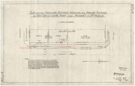
Item is a technical drawing which depicts an oblique aerial view of the south end of the Burrard Street Bridge and surrounding area, with a design for a proposed viaduct running from the south bridgehead south-westward over Kitsilano to Arbutus Street.
Item is a topographical map used as a base for showing surveying information such as lot numbers, boundaries, contours, bearings, pipelines, bridge and rail rights-of-way and other landmarks on the Kitsilano Indian Reserve. The map was likely used in planning the development of Vanier Park and/or the Vancouver Museum in the mid-late 1960s. Annotations show "most likely entrance" at McNicoll Avenue.