![[View of Georgia Street looking east from Broughton Street]](/uploads/r/null/b/3/b36a0ffb562445ab07907f340f899fb198d3da341503d87325ba6f798192024b/5888eb3d-0b22-4147-b01a-3a4f70ddb45c-A23490_142.jpg)
[View of Georgia Street looking east from Broughton Street]
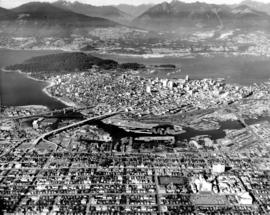
![Vancouver looking east from [Howe Sound]](/uploads/r/null/6/6/66fa4a6e8bb1ab5d20d8f951fa93ad57dd828be645aff6d182d88a8b36c69281/69bee6e1-54a6-4c8f-a7db-043e03b4dfe6-A23503_142.jpg)
Vancouver looking east from [Howe Sound]

Vancouver, B.C., Canada : aerial view of Downtown Vancouver, Burrard Inlet and the North Shore Mountains

Vancouver, B.C., Canada : West End and park - looking west to Point Atkinson

Vancouver, B.C., Canada : aerial view of downtown Vancouver, Burrard Inlet and North Shore Mountains
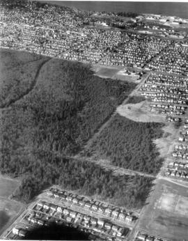
Cleaning for new site

Pacific National Exhibition
![[Aerial view looking east over the West End and Vancouver Harbour]](/uploads/r/null/7/2/72a6a15fa5e8b8bb00446ded690554cbc6e31a707a1b358bde2c463fbd514287/86590540-e15a-410c-8083-495eb213a7ca-A63256_142.jpg)
[Aerial view looking east over the West End and Vancouver Harbour]
![[Aerial photograph of downtown Nanaimo B.C.]](/uploads/r/null/9/b/9b5d6fcf945972bb10cacdedfe59a314267f99d1ef992e2e700a51cbe2bc7f80/6c0c2c60-d22a-48c1-b603-cdfa6801ce19-A38723_142.jpg)
[Aerial photograph of downtown Nanaimo B.C.]
![[Aerial view of fire at Vancouver sawmill]](/uploads/r/null/2/6/261c182ef20aa4aa00d0b46917096bf17c339730ec5975e81a6c1fbc2b63158f/05be5137-bdbf-42ad-a142-3e73d5538015-A71287_142.jpg)
[Aerial view of fire at Vancouver sawmill]

Pacific National Exhibition

Aerial view of Empire Stadium
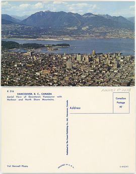
Vancouver, B.C., Canada : Aerial view of Downtown Vancouver with harbour and North Shore Mountains

Aerial photograph of P.N.E. grounds and New Brighton area

Cannery Site, West Vancouver

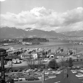
Cleaning for new site

Cleaning for new site
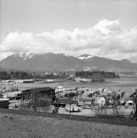
Cleaning for new site

Pacific National Exhibition
![[Aerial view of Penticton]](/uploads/r/null/8/f/8f1673cf7b568c702059a7bb01ec0ba85c06f3cf9a47524a8386b11430e0132a/25387856-45a8-4afd-9261-5b2d8d57523d-A34091_142.jpg)
[Aerial view of Penticton]
![[Aerial view of] English Bay Beach [the West End and Coal Harbour]](/uploads/r/null/b/b/bb7c88b9152ef2f0cd0c703a1f4b8ec3bb0049756fc1b2866fca72704a96421a/73ce5f2f-8ac1-4465-aa81-d5454e7356bb-A23489_142.jpg)
[Aerial view of] English Bay Beach [the West End and Coal Harbour]

Pageant of the Pacific structure superimposed over aerial view of P.N.E. grounds looking south
Vancouver from the air looking north from over Little Mountain
![[View of fire at lumber yard - B.C. Forest Products fire?]](/uploads/r/null/9/b/b/9bb7b1121a5a4c910f4d3264b043a9f028cc0099a2b18e0f2606d798651b2662/edfdcb36-ab3c-4829-adf0-63aafb6fd88a-CVA354-416_142.jpg)
[View of fire at lumber yard - B.C. Forest Products fire?]

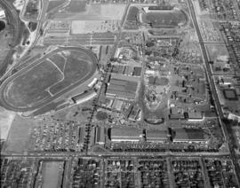
Aerial view of P.N.E. grounds and surrounding area looking northeast

Aerial view of P.N.E. grounds and surrounding area looking east

Aerial view of P.N.E. grounds and surrounding area looking northwest

Aerial view of P.N.E. grounds and surrounding area looking northeast

Aerial view of P.N.E. grounds and surrounding area looking northeast

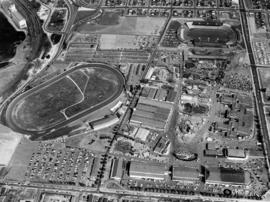
Aerial views of P.N.E. grounds

Aerial view of P.N.E. grounds

Aerial view of P.N.E. grounds and surrounding area
Aerial view of P.N.E. grounds and surrounding area
![[View looking northeast from north shore of False Creek over Smithe Street]](/uploads/r/null/8/f/6/8f6d7814ac04d1498743ba52bf07caf7e8dd2cf0290eb319665712b1edfdc180/c5c831e7-835b-48ff-8c87-5c157412dc0c-CVA145-2_142.jpg)
[View looking northeast from north shore of False Creek over Smithe Street]

Aerial views of P.N.E. grounds and surrounding area

Aerial view of P.N.E. grounds and surrounding area

Aerial view of P.N.E. grounds

Aerial view of P.N.E. grounds

Aerial view of P.N.E. grounds and surrounding area
Aerial view of P.N.E. grounds

Ferguson Point and Third Beach area
![[Aerial photograph of downtown Nanaimo B.C.]](/uploads/r/null/6/5/65cde66194e385688e218734e0d220ed5ee7ad328ef1509e29b092e2bccd990c/9b09da99-a3e3-4278-bfef-a729495916b4-A38724_142.jpg)
[Aerial photograph of downtown Nanaimo B.C.]
Aerial view of Camosun Park
Aerial view of Camosun Park
Aerial view of Camosun Park
Aerial view of Memorial West Park
Aerial view of Memorial West Park
![[Aerial view looking south of the] District of North Vancouver [between Seymour and Lynn Creeks]](/uploads/r/null/e/f/efec87eb86f83a0865fb63dd855e51942b3f5e6b75c5f105b15ef3db57d5b5c9/107091fb-3414-4f25-bc79-e59cee44fbab-A23496_142.jpg)
[Aerial view looking south of the] District of North Vancouver [between Seymour and Lynn Creeks]
![[Aerial view of] downtown bounded by Burrard Street, West Georgia Street, Granville Street and Sm...](/uploads/r/null/9/1/a/91aa0079c35a13cc3a22b0f7df0fb214970095aab0b5d871e09523e0499e3dac/42b18aee-e75f-4548-9e3a-bf196c0130ce-CVA145-17_142.jpg)
[Aerial view of] downtown bounded by Burrard Street, West Georgia Street, Granville Street and Smithe Street]
![[Aerial view looking north of the] Vancouver Wharves Ltd.](/uploads/r/null/a/3/a3e50a2d6a7688fca44a9f2fae2ec7ad724640047b3512a075ae83d4e5a3378e/ce172262-4f02-498d-ab6c-e23b06e50b09-A23502_142.jpg)
[Aerial view looking north of the] Vancouver Wharves Ltd.
![[Aerial view looking south-west of the] District of North Vancouver](/uploads/r/null/0/d/0d8adb3b55d68b7df4c4925829b8ff3b87c6f13f3a1ec81d303a4854c57064b0/0e67b80d-8372-4feb-93c5-e9c63b1d4541-A23499_142.jpg)
[Aerial view looking south-west of the] District of North Vancouver

West End from the air