![[Woman standing outside store at Hastings and Sperling Streets, Burnaby]](/uploads/r/null/9/f/9f030259a55b649996be4477c79f1270eaa864464bfa9cbaf51ce13a34ddf985/d16e4592-af1d-4700-818e-1a1538086087-A04089_142.jpg)
[Woman standing outside store at Hastings and Sperling Streets, Burnaby]
- AM54-S4-: SGN 183
- Item
- [1913?]
Part of Major Matthews collection
J.S. Matthews' notes with print or negative in Archives.
[Woman standing outside store at Hastings and Sperling Streets, Burnaby]
Part of Major Matthews collection
J.S. Matthews' notes with print or negative in Archives.
![[W.J. Devitt, Chief Constable]](/uploads/r/null/b/b/bb9be4bfa7105baeaebd6f7ababe893e60c838750acb75b5d2a8598b815b158c/a05de874-8b85-48bd-8c15-54cb4f5acad7-A34468_142.jpg)
[W.J. Devitt, Chief Constable]
Part of Major Matthews collection
![[Wild cat shot at Burnaby Lake by Walter Lewis]](/uploads/r/null/c/7/c702cb756232104ea66147ae1096e87119a9822a50345a4ec40a3be204acbcc2/d283eaf8-8b1a-4a90-bd50-181584e0f3ee-A26953_142.jpg)
[Wild cat shot at Burnaby Lake by Walter Lewis]
Part of Major Matthews collection
![[Westminster Road (Kingsway) looking east from Boundary Road]](/uploads/r/null/5/d/5da4af5ec085796774a1b8269832b836f02cb0a4f9a9deacd20718c54e6b4d37/a97b486d-8050-4dd0-978d-152bf99e93b5-A37340_142.jpg)
[Westminster Road (Kingsway) looking east from Boundary Road]
Part of Major Matthews collection
![[Walter Lewis and a display of ducks]](/uploads/r/null/b/1/b14e5e1f7611fc05e24e03c9c7179410b2b25f4e1e97a657ba6ceee98d22c020/8dbf8fb1-d63d-4bf3-8625-c1f12a4ead00-A26954_142.jpg)
[Walter Lewis and a display of ducks]
Part of Major Matthews collection
![Vosper family [picnic at] Central Park, Burnaby](/uploads/r/null/8/9/89714d628e424ad367b23f09ad40444685744da1a6a4e102e83873b327789172/b96b427e-40a3-451c-b97f-f4db4a98cb24-A02229_142.jpg)
Vosper family [picnic at] Central Park, Burnaby
Photograph shows various men, women, and children assembled around a long table.
![[View of Walter V. Bainbridge's ranch from Burnaby Lake]](/uploads/r/null/f/8/f83e27eeb6df5ffe2f00f65f295743c655cd822989310631971439da8226b178/d8425ba4-87e8-41de-b392-77c328f25014-A26941_142.jpg)
[View of Walter V. Bainbridge's ranch from Burnaby Lake]
Part of Major Matthews collection
![[View of the Prefabricated Buildings Ltd. factory and storage yard]](/uploads/r/null/f/2/f251fbcd82e80db4eab4f43d8f53fdf0b097c4eafbc8abb11f7ea62adad19d76/ec3963f3-cd5f-4202-9935-232b3b18dc12-A63615_142.jpg)
[View of the Prefabricated Buildings Ltd. factory and storage yard]
Part of Major Matthews collection
![[View of the east end of Burnaby Lake showing outlet to the Brunette River]](/uploads/r/null/2/8/287cf1cf347df5a8d8b9cf08fc64a8b983b7db93ad19212ea97f5f6c986dad92/1c3231f1-56bb-4e9f-8920-dfb83d60fd76-A10066_142.jpg)
[View of the east end of Burnaby Lake showing outlet to the Brunette River]
Part of Major Matthews collection
![[View of Kingsway looking west from Sperling Avenue]](/uploads/r/null/4/3/43d25be869566d1e4e2256f21bc78491a12509247f31c69459bc8c9d82b945bf/5e7eaaa1-85b6-42c6-8ff2-8ce73db26680-A00959_142.jpg)
[View of Kingsway looking west from Sperling Avenue]
Part of Stuart Thomson fonds
Photograph shows the intersection of Hawthorne Avenue on the south side of Kingsway, Lloyd's Confectionery and the cupola of Burnaby South High school.
![[View of Burnaby Lake from Sperling Avenue]](/uploads/r/null/c/d/cd9095c3f0ad82f27a6b94abce86e0178b1acf2d30c711afd269f7087dac56ca/1bd744ba-99ce-4064-b591-9d81cf53b5cd-A09330_142.jpg)
[View of Burnaby Lake from Sperling Avenue]
Part of Major Matthews collection
Photograph shows houses and farmland with lake in distance.
![[View of Burnaby Lake from Sperling Avenue]](/uploads/r/null/2/6/2656fda933db3606e91fc48c4a8599873e6c0a29f9ab398400cf1d4bc6998878/afc5b5a2-977f-4402-982f-91cf145ce5c9-A09332_142.jpg)
[View of Burnaby Lake from Sperling Avenue]
Part of Major Matthews collection
![[View of Burnaby Lake from Sperling Avenue]](/uploads/r/null/a/4/a4efb0e70af49c8c3aac3d14b1e4e2f2159988e1fa86782986ef35b0721c55aa/e54678de-4a9c-4324-8e3c-5675aa31753f-A09333_142.jpg)
[View of Burnaby Lake from Sperling Avenue]
Part of Major Matthews collection
Photograph shows tree stumps on land being cleared with lake in distance. J.S. Matthews' notes with print or negative in Archives.
![[View of Burnaby Lake from junction of Grandview Highway and Douglas Road at Sperling]](/uploads/r/null/c/6/c6a67fc0f5ca62330e450612918fb0fc8fc2380cf29b29f9dd9bacfc41b1fa3d/602e794a-6571-4f54-b5cd-a3aa947d8d53-A10064_142.jpg)
[View of Burnaby Lake from junction of Grandview Highway and Douglas Road at Sperling]
Part of Major Matthews collection
Photograph shows cultivated fields, houses and the lake in the distance.
![[View of Burnaby Lake]](/uploads/r/null/2/2/22481b50cc3b9bcc1e2c3d7d4138b8072e7ec6076b37bf74c07125fced50679d/16045df0-cef7-4d68-83de-32376ce17f63-A10065_142.jpg)
Part of Major Matthews collection
Photograph shows area of Lake City Industrial Development.
![[View of Bainbridge Ranch from Burnaby Lake]](/uploads/r/null/f/a/fa0788db653abd785d8eef1dfda31947db088dcc5802fa6631fb04006a2f7559/38ca2d54-1361-4e79-bca3-e111b52f709b-A59968_142.jpg)
[View of Bainbridge Ranch from Burnaby Lake]
Part of Major Matthews collection

View from north side of Burnaby Lake
Part of Major Matthews collection
Photograph shows railway tracks in foreground and houses and fields across lake.

View from north side of Burnaby Lake
Part of Major Matthews collection
Photograph shows houses and fields across lake.

View from north side of Burnaby Lake
Part of Major Matthews collection
Photograph shows railway tracks in foreground and houses and fields across lake.

Vancouver Centennial display at Lougheed Mall

Vancouver Centennial display at Lougheed Mall
![[Two storey home with car parked by garage]](/uploads/r/null/8/2/8/828d6edd52754940a09551f7c8be129f9e9b090b999574f3d2c77d5122989ff3/21af3d05-9057-47c0-ad3f-4a70a78d3211-CVA16-5_142.jpg)
[Two storey home with car parked by garage]
Item is a photograph showing the home of Burnaby Councillor Charles Rummel and family, then located at 1805 Inverness Street in Burnaby.
![[Two coupled interurban cars] at station on the B.C.E.R. Central Park lines](/uploads/r/null/b/f/bff4fd779ef9b55e93eb606a6df2ec7db7dee7aaca7ef1db8c07cc0759a14b14/d5da973a-464d-4154-8fa6-0846c6e633aa-A02218_142.jpg)
[Two coupled interurban cars] at station on the B.C.E.R. Central Park lines

Part of City of Vancouver Archives technical and cartographic drawing collection
Map shows Hastings Town-site, Granville Town-site, Burnaby, and the City of New Westminster. Map also shows the Road from Granville and the False Creek Trail, as well as the names of places and soil types found along these roads. Other places and structures noted include Burrard Inlet, Coal Harbour (Coal Harbor on map), False Creek, False Creek Bridge, Burnaby Lake, Fraser River, New Westminster and Burrard Inlet Road, Douglas Road, Edinburgh Street, Columbia Street, Richards Street, and the New Westminster Cemetery. Two notes on map read "Plan to accompany Report of 1st May 1883, Joseph Hunter" and "Memo: Mr. Ross will place [?] this map to the [Engs.] Office Victoria [?]." 14T3 Roads & Trails is printed on the side of the map.

Tillicum interacting with children at Lougheed Mall
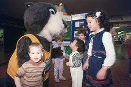
Tillicum interacting with children at Lougheed Mall
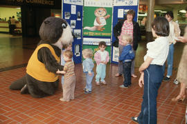
Tillicum interacting with children at Lougheed Mall
Tillicum interacting with children at Lougheed Mall
Tillicum interacting with children at Lougheed Mall

Tillicum interacting with children at Lougheed Mall

Tillicum interacting with children at Lougheed Mall
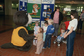
Tillicum interacting with children at Lougheed Mall

Tillicum interacting with children at Lougheed Mall

Tillicum interacting with children at Lougheed Mall

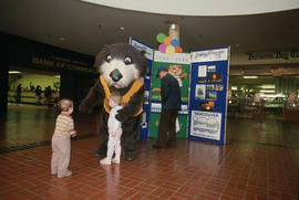
Tillicum in front of Vancouver Centennial display at Lougheed Mall

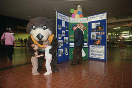
Tillicum beside Centennial display at Lougheed Mall


This photo shows section of track looking looking round the curve towards Central Park
Part of Major Matthews collection

This photo shows section of track looking east towards Edmonds. Old "1222" is off ot the left.
Part of Major Matthews collection
![[The wreck of Great Northern Railway train and engine No. 202 near Burnaby Lake]](/uploads/r/null/8/c/8c120a4630e58ec6d8ede7b74872a099c2d81d36816091c5d03a7f59f92b5a8d/05948ab1-0906-4e2d-adcd-79b1683f14b6-A62610_142.jpg)
[The wreck of Great Northern Railway train and engine No. 202 near Burnaby Lake]
Part of Major Matthews collection
![[The grounds of the old Agricultural Hall at Central Park]](/uploads/r/null/5/7/5740ee66afb05f27df06f3f11a2edd491f74e99765a65eae3ad7d0b41468d4f5/f3523c8d-7342-4f36-933e-93971fd453a8-A62245_142.jpg)
[The grounds of the old Agricultural Hall at Central Park]
Part of Major Matthews collection
![[The first Presbyterian church on Westminster Road at Central Park]](/uploads/r/null/7/a/7af7e066a5a36137b09777bf14ef138d65e57624fe108c4c17162c7b38d3470b/0d21bdb9-1ecb-4d5a-9629-16a1bff50a2c-A25564_142.jpg)
[The first Presbyterian church on Westminster Road at Central Park]
Part of Major Matthews collection
![[The 2nd Battalion, Canadian Garrison Artillery at Central Park Rifle Range]](/uploads/r/null/1/5/15534f2bbf9bead05a9d594322ee886c2498228fd43fb14e44d4de5d333b7bfe/a7f58baf-0ab5-44ef-b9ee-83bdcd3fdde9-A32064_142.jpg)
[The 2nd Battalion, Canadian Garrison Artillery at Central Park Rifle Range]
Part of Major Matthews collection
Group portrait showing Lieutenant J. Reynolds Tite, Corporal J. Sperring, Gunner William Croy and others
![Taken for Duker and Shaw Billboards Ltd. [Kingsway and Patterson]](/uploads/r/null/e/4/e4a8244ab612b09825e93b392a376780c1d7abe042605aa020b78526e5a03bc9/28e2596b-98a2-4594-a7a1-05ed5fbfb100-A00930_142.jpg)
Taken for Duker and Shaw Billboards Ltd. [Kingsway and Patterson]
Part of Stuart Thomson fonds
![[Students of the first public school near the southeast corner of Edmonds Street and Douglas Road]](/uploads/r/null/b/6/b623f88197af9f78121fd65e2ea78e5d5ef265a3ed8922be9b90624ddaf36416/f83d66a8-ea25-40ad-9175-18f6bf1eccdf-A36438_142.jpg)
[Students of the first public school near the southeast corner of Edmonds Street and Douglas Road]
Part of Major Matthews collection
Group portrait showing Trustees B.R. Hill, L. Grimmer and William McDermott and the children
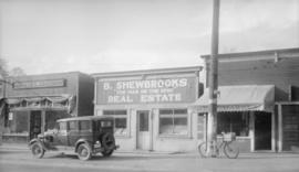
Storefront of B. Shewbrooks "The Man on the Spot" Real Estate, Insurance, Architect
Photograph shows B. Shewbrooks storefront located at 4513 Kingsway, including the Red and White store and Wigley Meat Market.