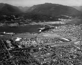
Aerial view of P.N.E. grounds and surrounding area looking north
- AM281-S8-: CVA 180-5229
- Item
- [1964?]
18 results with digital objects Show results with digital objects
Aerial view of P.N.E. grounds and surrounding area looking north

Aerial view of P.N.E. grounds and surrounding area looking northeast

Aerial view of P.N.E. grounds and surrounding area looking west

Aerial view of P.N.E. grounds and surrounding area looking southwest
![[Aerial view of Vancouver showing the Fraser River]](/uploads/r/null/d/b/db0369bf59a848e9764e3b839c47c8ec7201f99a4017bbddd8512f47ca26200f/5ab47fec-a8ce-4ad4-a81e-ae2c39689e5a-A13723_142.jpg)
[Aerial view of Vancouver showing the Fraser River]
![[Aerial view of Vancouver]](/uploads/r/null/b/6/b61e5089ec8edb824f16eea9b4373dfb3ac9ea83b052f855a90859c3a7424f4c/c7a56b73-012c-4e6d-b4e3-c362735e3a05-A13726_142.jpg)
![[View of the Goodyear blimp taken from an airplane above Vancouver]](/uploads/r/null/3/3/3336881308e1e37de96b9ef201f813bbbd6e2db7aa1821f78400ef5a8deb32ff/5b651868-2938-4420-a791-777473cdb6e8-A13724_142.jpg)
[View of the Goodyear blimp taken from an airplane above Vancouver]
![[Aerial view of Vancouver showing the Goodyear blimp]](/uploads/r/null/8/e/8e555d9af3baf3296446345ad718a4b310d778d587429ac7d783ddf6d0bd1a28/11f7d743-9030-4973-aec6-c44fd5ba4e7c-A13727_142.jpg)
[Aerial view of Vancouver showing the Goodyear blimp]
![[Aerial view of Vancouver showing the Goodyear blimp above the Downtown area]](/uploads/r/null/8/4/845b713451cd89bf22d1340d07a741cc7c4b68ce884237a8bf7db719fb1f8a0c/f7115108-1cb7-4a7e-b6f7-b767fbd53e1d-A13728_142.jpg)
[Aerial view of Vancouver showing the Goodyear blimp above the Downtown area]
![[Aerial view of Vancouver showing the Goodyear blimp]](/uploads/r/null/a/d/ad5d6048618bc821a9d06934fa1761a7e251dafba8693dc6f459758258ed169f/ffc49cb9-3d17-409a-b2a2-f9c574508d81-A13730_142.jpg)
[Aerial view of Vancouver showing the Goodyear blimp]
![[Aerial view of Vancouver]](/uploads/r/null/b/4/b48d4b96f8547ec1a2bf06286a2cb6ded5510700d395242e2bcb283c884cdcc0/3730cb73-0bef-4e47-843a-9953c8d8e913-A13729_142.jpg)
![[Aerial view of downtown Vancouver]](/uploads/r/null/9/5/953f0d3ea8e3ecbb55e2210d94ead53f5be11ac38f8801476c6f0a576bc5953d/f265a01b-d073-47c0-99e1-e2832c475ddb-A13733_142.jpg)
[Aerial view of downtown Vancouver]
![[View of farm buildings and fields taken from the air]](/uploads/r/null/9/b/9b1f700b1bdee44fb2534cdd56a164987f3e8bb21e6f247ae7822623a2df94dc/7d25fb85-64f0-4eca-a154-b9f6d0bc65bf-A13721_142.jpg)
[View of farm buildings and fields taken from the air]
![[Aerial view of Vancouver]](/uploads/r/null/7/0/70fe55216d34bcc4ff4f671e2d7814e6d15c21dd5aaf76b58bc6469a40388a1d/c25263bf-0975-439c-bc93-248713d79567-A13722_142.jpg)
![[Aerial view of Vancouver]](/uploads/r/null/d/7/d7f280a1021ddedf2aae71722e35fd9ee91a1e6d3f2e31003eed6fec146e27e7/e30c0e8a-964a-484e-90db-349ad9165b2f-A13725_142.jpg)
![[Aerial view of Vancouver showing CPR piers, Coal Harbour, and Stanley Park]](/uploads/r/null/8/2/82143d16653193252b06da622f500eff3170f5e7e984e78ebfaf6f92255a4522/68bb2619-41d4-40a4-bce2-8562cad89b9e-A13731_142.jpg)
[Aerial view of Vancouver showing CPR piers, Coal Harbour, and Stanley Park]
![[Aerial view of piers in Coal Harbour and part of downtown Vancouver]](/uploads/r/null/3/d/3dea4ff428030ca6b9c2fedd905fb85bdb6565d2e128563bae589050d4b0f133/2cddd923-ab3c-4a2c-be2b-fd929084db11-A13732_142.jpg)
[Aerial view of piers in Coal Harbour and part of downtown Vancouver]
![[Aerial view of Vancouver showing piers along the waterfront looking east]](/uploads/r/null/d/4/d4bb5ecff1c03cb6c58a6b9e983755d30fc68d1f35ccda97bbc0817e3cd99e96/8729b350-60b7-4857-97ca-7ce5014b9d0c-A13902_142.jpg)
[Aerial view of Vancouver showing piers along the waterfront looking east]