![[Park in Kitsilano]](/uploads/r/null/5/0/50865667f2f73aaa6f5a1276ba9d89dff63332daa130139ff3cf4a79afb9dec7/438ccbe4-ec5f-4389-b02a-3538e004f960-A58937_142.jpg)
- COV-S511---: CVA 780-157
- Item
- Oct. [19]74
Part of City of Vancouver fonds
Part of City of Vancouver fonds
![[Point Grey Road Waterfront Park]](/uploads/r/null/c/9/c9faa13bb2b8c2f0c429b90d90f959707687ba72f7bd3c75e051e307f14f8b61/85333e38-c299-4184-ad33-fece41a848f0-A58944_142.jpg)
[Point Grey Road Waterfront Park]
Part of City of Vancouver fonds
Photograph also shows the North Shore and Stanley Park
![[Park in the West End]](/uploads/r/null/3/d/3dad80ee0d6f8a595572501c5dbf904b08690829d9a02b2491ce2c6a73a886cd/f2a58b6c-d987-44cf-b30a-4302576d561d-A59277_142.jpg)
Part of City of Vancouver fonds
Photograph also shows three tower apartment buildings

Part of City of Vancouver fonds
![[Cityscape of Kitsilano looking North]](/uploads/r/null/2/0/20a1900669c168d04ff275a3805145786dc47a4943e313105af3e5000e9617fc/af1fdd04-91e0-4295-a233-74504a743335-A58955_142.jpg)
[Cityscape of Kitsilano looking North]
Part of City of Vancouver fonds
Photograph also shows the North Shore and Stanley Park
![Corner Dunlevy [Avenue] and Powell [Street] Oppenheimer Park](/uploads/r/null/5/e/5e2c24ea07e01c23c25892784877e9a3be5d15b8555f00e28611a49c07704b64/f536c908-7c91-416d-bccb-8e97f2719fb0-A59237_142.jpg)
Corner Dunlevy [Avenue] and Powell [Street] Oppenheimer Park
Part of City of Vancouver fonds
Photograph also shows Wings Hotel (143 Dunlevy Avenue)

Vancouver skyline, Coal Harbour, and Stanley Park seawall beach
Part of City of Vancouver fonds

Vancouver skyline, Coal Harbour, and Stanley Park seawall beach
Part of City of Vancouver fonds
Part of City of Vancouver fonds
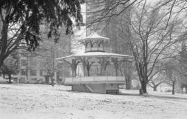
Item is a photograph showing the Alexandra Bandstand.

Sheet 10 : Clark Drive to Slocan Street and Burrard Inlet to Triumph Street
Part of City of Vancouver fonds
Item is a section showing the area from Clark Drive to Slocan Street and aterfront to Triumph Street. Includes streets and roads, blocks, lots, legal descriptions, railways, parks, boys' detention home and businesses along the waterfront. The Town of Hastings is indicated on the map. Map is hand coloured to show tax sale property for sale, property with no water, street widening and drainage, replotting, reserved land for schools, reserved land for parks, sundry land, capital assets not including schools and parks, schools, and parks, as applicable.
Vancouver (B.C.). Office of the City Engineer

Sheet 8 : McLean Drive to Slocan Street and William Street to Seventh Avenue
Part of City of Vancouver fonds
Item is a section showing the area from McLean Drive to Slocan Street and William Street to Seventh Avenue. Includes streets and roads, blocks, lots, legal descriptions, railways, parks, schools and some businesses. Map is hand coloured to show tax sale property for sale, property with no water, street widening and drainage, replotting, reserved land for schools, reserved land for parks, sundry land, capital assets not including schools and parks, schools, and parks, as applicable. Some annotations have been made in pencil.
Vancouver (B.C.). Office of the City Engineer

Sheet 16 : Maple Street to Oak Street and False Creek to Sixteenth Avenue
Part of City of Vancouver fonds
Item is a section showing Maple Street to Oak Street and False Creek to Sixteenth Avenue. Includes streets and roads, blocks, lots, legal descriptions, railways, schools and parks. Indicates crown land leased to the C.P.R. and other bodies. Map is hand coloured to show tax sale property for sale, property with no water, street widening and drainage, replotting, reserved land for schools, reserved land for parks, sundry land, capital assets not including schools and parks, schools, and parks.
Vancouver (B.C.). Office of the City Engineer

Sheet 18 : Trutch Street to Maple Street and English Bay to Third Avenue
Part of City of Vancouver fonds
Item is a section showing Trutch Street to Maple Street and English Bay to Third Avenue. Includes streets, roads, blocks, lots, legal descriptions, parks and crown grants. Map is hand coloured to show tax sale property for sale, property with no water, street widening and drainage, replotting, reserved land for schools, reserved land for parks, sundry land, capital assets not including schools and parks, schools, and parks.
Vancouver (B.C.). Office of the City Engineer

Sheet 21 : Burrard Street to False Creek and waterfront to Robson Street
Part of City of Vancouver fonds
Item is a section showing Burrard Street to False Creek and waterfront to Robson Street. Includes streets and roads; blocks, lots and legal descriptions; the locations of hotels, court house, businesses, parks, and schools; crown leases; C.P.R. land and the company's Piers B and C, yards, sheds and depot; the B.C. Electric Railway Carrall Street Yard; and the Union Steamship Company. Map is hand coloured to show tax sale property for sale, property with no water, street widening and drainage, replotting, reserved land for schools, reserved land for parks, sundry land, capital assets not including schools and parks, schools, and parks, as applicable.
Vancouver (B.C.). Office of the City Engineer

Sheet 6 : Knight Street to Slocan Street and Eighteenth Avenue to Twenty-ninth Avenue
Part of City of Vancouver fonds
Item is a section showing the area from Knight Street to Slocan Street and Eighteenth Avenue to Twenty-ninth Avenue. Includes streets and roads, blocks, lots, legal descriptions, railways, parks and schools. Some annotations have been made in pencil. Map is hand coloured to show tax sale property for sale, property with no water, street widening and drainage, replotting, reserved land for schools, reserved land for parks, sundry land, capital assets not including schools and parks, schools, and parks. Map is hand coloured to show tax sale property for sale, property with no water, street widening and drainage, replotting, reserved land for schools, reserved land for parks, sundry land, capital assets not including schools and parks, schools, and parks, as applicable.
Vancouver (B.C.). Office of the City Engineer

Sheet D : Imperial Street to Trutch Street and Fourth Avenue to Sixteenth Avenue
Part of City of Vancouver fonds
Item is a section showing the area from Imperial Street to Trutch Street and Fourth Avenue to Sixteenth Avenue. Includes streets and roads; blocks; lots and legal descriptions; and parks, schools and golf courses. Section is annotated to show tax sale property for sale, property with no water, street widening and drainage, replotting, reserved land for schools, reserved land for parks, sundry land, capital assets not including schools and parks, schools, and parks, as applicable.
Vancouver (B.C.). Office of the City Engineer

Sheet G : Trafalgar Street to Granville Street and Sixteenth Avenue to Nanton Avenue
Part of City of Vancouver fonds
Item is a section showing the area from Trafalgar Street to Granville Street and Sixteenth Avenue to Nanton Avenue. Includes streets, roads and sewers; blocks, lots and legal descriptions; and parks, railway lines and schools. Section is annotated to show tax sale property for sale, property with no water, street widening and drainage, replotting, reserved land for schools, reserved land for parks, sundry land, capital assets not including schools and parks, schools, and parks, as applicable.
Vancouver (B.C.). Office of the City Engineer

Sheet X : Marine Drive to Ash Street and Fifty-ninth Avenue to Seventy-first Avenue
Part of City of Vancouver fonds
Item is a section showing the area from Marine Drive to Ash Street and Fifty-ninth Avenue to Seventy-first Avenue. Includes streets and roads; blocks, lots and legal descriptions; and parks and schools. Map is hand coloured to show tax sale property for sale, property with no water, street widening and drainage, replotting, reserved land for schools, reserved land for parks, sundry land, capital assets not including schools and parks, schools, and parks, as applicable.

Sheet 6 : Craddock Street to Boundary Road and Twenty-ninth Avenue to Fortieth Avenue
Part of City of Vancouver fonds
Item is a section showing the area from Craddock Street to Boundary Road and Twenty-ninth Avenue to Fortieth Avenue. Includes streets, roads, blocks, lots, legal descriptions, parks. railway lines and schools. Map is hand coloured to show tax sale property for sale, property with no water, street widening and drainage, replotting, reserved land for schools, reserved land for parks, sundry land, capital assets not including schools and parks, schools, and parks, as applicable.
Vancouver (B.C.). Office of the City Engineer

Sheet 3 : Cambie Street to St. George Street and Twenty-seventh Avenue to Thirty-eighth Avenue
Part of City of Vancouver fonds
Item is a section showing the area from Cambie Street to St. George Street and Twenty-seventh Avenue to Thirty-eighth Avenue. Map shows streets, roads, blocks, lots and legal descriptions and the locations of parks, schools, reservoirs and Mountainview Cemetery. Map is hand coloured to show tax sale property for sale, property with no water, street widening and drainage, replotting, reserved land for schools, reserved land for parks, sundry land, capital assets not including schools and parks, schools, and parks, as applicable.
Vancouver (B.C.). Office of the City Engineer

Sheet 13 : Fleming Street to Carlton Street and Forty-seventh Avenue to Fifty-ninth Avenue
Part of City of Vancouver fonds
Item is a section showing the area from Fleming Street to Carlton Street and Forty-seventh Avenue to Fifty-ninth Avenue. Includes streets, roads, blocks, lots, legal descriptions, parks and schools. Map is hand coloured to show tax sale property for sale, property with no water, street widening and drainage, replotting, reserved land for schools, reserved land for parks, sundry land, capital assets not including schools and parks, schools, and parks, as applicable.
Vancouver (B.C.). Office of the City Engineer

Sheet 11 : Cambie Street to St. George Street and Forty-seventh Avenue to Fifty-eighth Avenue
Part of City of Vancouver fonds
Item is a section showing the area from Cambie Street to St. George Street and Forty-seventh Avenue to Fifty-eighth Avenue. Includes streets, roads, blocks, lots, legal descriptions, golf courses, parks and schools. Map is hand coloured to show tax sale property for sale, property with no water, street widening and drainage, replotting, reserved land for schools, reserved land for parks, sundry land, capital assets not including schools and parks, schools, and parks, as applicable.
Vancouver (B.C.). Office of the City Engineer

Sheet 9 : Fleming Street to Carlton Street and Thirty-seventh Avenue to Forty-eighth Avenue
Part of City of Vancouver fonds
Item is a section showing the area from Fleming Street to Carlton Street and Thirty-seventh Avenue to Forty-eighth Avenue. Includes streets, roads, blocks, lots, legal descriptions, parks and schools. Map is hand coloured to show tax sale property for sale, property with no water, street widening and drainage, replotting, reserved land for schools, reserved land for parks, sundry land, capital assets not including schools and parks, schools, and parks, as applicable.
Vancouver (B.C.). Office of the City Engineer

Part of City of Vancouver fonds
Item is a photograph, which may depict an example of Populus alba.
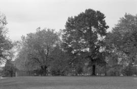
Un-named trees, Sunnyside Park (N.I.I.)
Part of City of Vancouver fonds

Part of City of Vancouver fonds

Part of City of Vancouver fonds

Part of City of Vancouver fonds

Stanley Park, Kiwanis Club Rose Plot
Part of City of Vancouver fonds

Stanley Park, Brockton Point Lighthouse
Part of City of Vancouver fonds

Stanley Park, Brockton Point Lighthouse
Part of City of Vancouver fonds
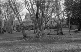
Tatlow Park, interior, looking east - Vine Maples
Part of City of Vancouver fonds
Part of City of Vancouver fonds

Part of City of Vancouver fonds

David Oppenheimer memorial, front view
Part of City of Vancouver fonds

Part of City of Vancouver fonds

Oak Park, looking west - Row of Big Leaf Maples
Part of City of Vancouver fonds
Part of City of Vancouver fonds
Almond Park path on bank (not well articulated)
Part of City of Vancouver fonds

Stanley Park - Japanese Canadian War Memorial, north side
Part of City of Vancouver fonds

Stanley Park - Shakespeare Monument setting (beyond Rose Garden) Shakespeare Garden
Part of City of Vancouver fonds

Stanley Park - David Oppenheimer memorial bust
Part of City of Vancouver fonds

Part of City of Vancouver fonds

Part of City of Vancouver fonds

Stanley Park - HMS Egeria Bench Mark
Part of City of Vancouver fonds

Stanley Park - Japanese Canadian War Memorial, detail south side
Part of City of Vancouver fonds

Part of City of Vancouver fonds

Stanley Park - Air Force Garden of Remembrance, one of several tablets
Part of City of Vancouver fonds

Part of City of Vancouver fonds

Part of City of Vancouver fonds