
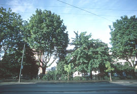
200 West Pender Street north side
- COV-S509-: CVA 778-257
- Item
- May 1974
Part of City of Vancouver fonds
Image shows the south side of Victory Square Park.
200 West Pender Street north side
Part of City of Vancouver fonds
Image shows the south side of Victory Square Park.
200 West Pender Street north side
Part of City of Vancouver fonds
Image shows the south side of Victory Square Park.
![[Kitsilano] Ice Rink [at 2495 West 12th Avenue]](/uploads/r/null/e/b/eb721478621e4bda9a57c84a63bed97f2584c3d59a11c99b4a350144e51252bd/dc26c67f-7ca8-4fe5-807c-7e3c8c3c65dc-A58967_142.jpg)
[Kitsilano] Ice Rink [at 2495 West 12th Avenue]
Part of City of Vancouver fonds
Photograph also shows Connaught Park, the Greater Vancouver Regl, Sewage and Drainage and Water Distict (2294 West 10th Avenue), and apartment buildings 2285 West 10th Avenue (Patna Apartments) and 2586 Vine Street
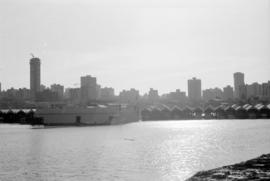
Vancouver skyline and waterfront from Stanley Park seawall
Part of City of Vancouver fonds
Item part is a photograph of the downtown Vancouver skyline and waterfront, looking south across Coal Harbour from the seawall path in Stanley Park. Boat storage units are visible along the coast.

Vancouver skyline and fuel barges from Stanley Park seawall
Part of City of Vancouver fonds
Item part is a photograph of the downtown Vancouver skyline and waterfront, looking south across Coal Harbour from the seawall path in Stanley Park. Several fuel barges (National, Home, and Esso) are visible in the harbour.

Vancouver skyline from Stanley Park seawall
Part of City of Vancouver fonds
Item part is a photograph of the downtown Vancouver skyline and waterfront, looking south across Coal Harbour from the seawall path in Stanley Park.

Vancouver skyline, Coal Harbour, and Stanley Park seawall beach
Part of City of Vancouver fonds

Sheet 15 : Ash Street to St. George Street and Fifty-eighth Avenue to Marine Drive
Part of City of Vancouver fonds
Item is a section showing the area from Ash Street to St. George Street and Fifty-eighth Avenue to Marine Drive.Includes streets, roads, blocks, lots, legal descriptions, parks and railway lines. Map is hand coloured to show tax sale property for sale, property with no water, street widening and drainage, replotting, reserved land for schools, reserved land for parks, sundry land, capital assets not including schools and parks, schools, and parks, as applicable. A note in ink at the top of the map indicates that "Brown-green refers to the Crippled Childrens Hospital Reserve."
Vancouver (B.C.). Office of the City Engineer

Sheet 16 : St. George Street to Argyle Street and Fifty-eighth Avenue to Fraser River
Part of City of Vancouver fonds
Item is a section showing the area from St. George Street to Argyle Street and Fifty-eighth Avenue to the Fraser River. Includes streets, roads, blocks, lots, legal descriptions, railway lines, parks and schools. Map is hand coloured to show tax sale property for sale, property with no water, street widening and drainage, replotting, reserved land for schools, reserved land for parks, sundry land, capital assets not including schools and parks, schools, and parks, as applicable.
Vancouver (B.C.). Office of the City Engineer

Sheet 2 : Slocan Street to Boundary Road and Charles Street to Triumph Street
Part of City of Vancouver fonds
Item is a section showing the area from Slocan Street to Boundary Road and Charles Street to Triumph Street. Includes streets, roads, blocks, lots, legal descriptions, parks, schools, and retirement homes. Section is annotated in colour to show tax sale property for sale, property with no water, street widening and drainage, replotting, reserved land for schools, reserved land for parks, sundry land, capital assets not including schools and parks, schools, and parks, as applicable.
Vancouver (B.C.). Office of the City Engineer

Sheet 1 : Slocan Street to Boundary Road and Triumph Street to Burrard Inlet
Part of City of Vancouver fonds
Item is a section showing the area bound by Slocan Street, Boundary Road, Triumph Street and the waterfront. Includes streets, roads, railways, blocks, lots, legal descriptions, quit claims, leases, parks and businesses along the waterfront. Section is annotated in colour to show tax sale property for sale, property with no water, street widening and drainage, replotting, reserved land for schools, reserved land for parks, sundry land, capital assets not including schools and parks, schools, and parks, as applicable.
Vancouver (B.C.). Office of the City Engineer

Sheet 23 : Stanley Park to Granville Street and Robson Street to False Creek
Part of City of Vancouver fonds
Item is a section showing the area from Stanley Park to Granville Street and Robson Street to False Creek. Includes streets, roads and railways; blocks, lots and legal descriptions; as well as parks, schools, hospitals and churches. Shows the Burrard Bridge and C.P.R. property. Map is hand coloured to show tax sale property for sale, property with no water, street widening and drainage, replotting, reserved land for schools, reserved land for parks, sundry land, capital assets not including schools and parks, schools, and parks, as applicable.
Vancouver (B.C.). Office of the City Engineer

Sheet A : University Endowment Lands to Imperial Street and waterfront to Fifth Avenue
Part of City of Vancouver fonds
Item is a section showing the area from the University Endowment Lands to Imperial Street and waterfront to Fifth Avenue. Includes streets, roads and sewers; blocks, lots and legal descriptions; and parks. Map is annotated to show tax sale property for sale, property with no water, street widening and drainage, replotting, reserved land for schools, reserved land for parks, sundry land, capital assets not including schools and parks, schools, and parks, as applicable.
Vancouver (B.C.). Office of the City Engineer

Sheet F : Wallace Street to Trafalgar Street and Sixteenth Avenue to Twenty-seventh Avenue
Part of City of Vancouver fonds
Item is a section showing the area from Wallace Street to Trafalgar Street and Sixteenth Avenue to Twenty-seventh Avenue. Includes streets, roads, blocks, lots, legal descriptions, parks and schools. Section is annotated to show tax sale property for sale, property with no water, street widening and drainage, replotting, reserved land for schools, reserved land for parks, sundry land, capital assets not including schools and parks, schools, and parks, as applicable.
Vancouver (B.C.). Office of the City Engineer

Sheet H : Alexandra Street to Cambie Street and Fifteenth Avenue to Twenty-seventh Avenue
Part of City of Vancouver fonds
Item is a section showing the area from Alexandra Street to Cambie Street and Fifteenth Avenue to Twenty-seventh Avenue. Includes streets, roads, blocks, lots, legal descriptions, parks, hospitals and schools. Section is annotated to show tax sale property for sale, property with no water, street widening and drainage, replotting, reserved land for schools, reserved land for parks, sundry land, capital assets not including schools and parks, schools, and parks, as applicable.
Vancouver (B.C.). Office of the City Engineer

Part of City of Vancouver fonds
Item is a section showing the area from the University Endowment Lands to Wallace Street and Twenty-ninth Avenue to Thirty-eighth Avenue. Includes streets, roads and sewers; blocks, lots and legal descriptions; and parks and schools. Section is annotated to show tax sale property for sale, property with no water, street widening and drainage, replotting, reserved land for schools, reserved land for parks, sundry land, capital assets not including schools and parks, schools, and parks, as applicable.
Vancouver (B.C.). Office of the City Engineer

Sheet W : Fraser River to French Street and Fifty-ninth Avenue to Seventy-first Avenue
Part of City of Vancouver fonds
Item is a section showing the area from Fraser River to French Street and Fifty-ninth Avenue to Seventy-first Avenue. Includes streets and roads; blocks, lots and legal descriptions; and parks and golf courses. Map is hand coloured to show tax sale property for sale, property with no water, street widening and drainage, replotting, reserved land for schools, reserved land for parks, sundry land, capital assets not including schools and parks, schools, and parks, as applicable.
Vancouver (B.C.). Office of the City Engineer

Sheet 4 : Prince Edward Street to Bruce Street and King Edward Avenue to Thirty-sixth Avenue
Part of City of Vancouver fonds
Item is a section showing the area from Prince Edward Street to Bruce Street and King Edward Avenue to Thirty-sixth Avenue. Map shows streets, roads, blocks, lots and legal descriptions, and the locations of parks, schools and Mountainview Cemetery. Map is hand coloured to show tax sale property for sale, property with no water, street widening and drainage, replotting, reserved land for schools, reserved land for parks, sundry land, capital assets not including schools and parks, schools, and parks, as applicable.
Vancouver (B.C.). Office of the City Engineer

Sheet 10 : Earles Street to Boundary Road and Fortieth Avenue to Fiftieth Avenue
Part of City of Vancouver fonds
Item is a section showing the area from Carlton Street to Boundary Road and Fortieth Avenue to Fiftieth Avenue. Includes streets, roads, blocks, lots, legal descriptions, parks and schools. Map is hand coloured to show tax sale property for sale, property with no water, street widening and drainage, replotting, reserved land for schools, reserved land for parks, sundry land, capital assets not including schools and parks, schools, and parks, as applicable.
Vancouver (B.C.). Office of the City Engineer

Part of City of Vancouver fonds
Part of City of Vancouver fonds

Stanley Park Pavilion and Sarder
Part of City of Vancouver fonds
![Kensington Park [1 of 17]](/uploads/r/null/b/6/b65d7297ebb97495f6790ed8ad70c936b1c6c64e283d3a8ce7b4d96cfd99beaa/105c3761-f79b-482f-909b-4c58bfe4225a-A66095_142.jpg)
Part of City of Vancouver fonds
![Kensington Park [8 of 17]](/uploads/r/null/d/8/d87616cce7c9a78c9bb14a0a62fe6057013550b968f4cac9f4d1afe96d607193/7c90dc1c-baca-4db4-9103-41e5dc191bc6-A66102_142.jpg)
Part of City of Vancouver fonds
![McSpadden Park [3 of 4]](/uploads/r/null/3/8/38afef77f189e7a394c9d4bff00243228f12a5ebbab098dc4ca68b8274577c2e/5446b27f-895c-41c0-a83e-8cc79a2e428d-A66105_142.jpg)
Part of City of Vancouver fonds
![Kensington Park [12 of 17]](/uploads/r/null/2/9/29352b4bb74218be7e18bb08260523fb32cf87e4b5508bc3e889bafeb928dd05/1420a3e5-41a6-4b75-a5af-2ba9ebf17881-A66329_142.jpg)
Part of City of Vancouver fonds
![Kensington Park [15 of 17]](/uploads/r/null/b/b/bbac12042c41d248e48bc5810042b7684af2ec4ec4fa4d05a2699650c5c1c97e/c2c01442-1bb8-4233-8687-7a48039cf353-A66332_142.jpg)
Part of City of Vancouver fonds

Quercus suber, Queen Elizabeth Park, near 37th Avenue and Cambie Street entrance (N.I.I.)
Part of City of Vancouver fonds

Part of City of Vancouver fonds

Stanley Park, southwest entrance
Part of City of Vancouver fonds

Stanley Park, Robert Burns Monument
Part of City of Vancouver fonds

Stanley Park, Queen Elizabeth II Coronation Oak
Part of City of Vancouver fonds
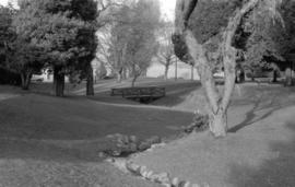
Tatlow Park, wooden bridge, stream edge looking north
Part of City of Vancouver fonds

Tatlow Park, wooden bridge, stream edge looking south
Part of City of Vancouver fonds

Part of City of Vancouver fonds
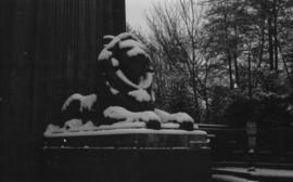
Lion's Gate Bridge lion sculpture, angled view
Part of City of Vancouver fonds
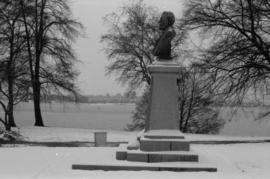
David Oppenheimer memorial, side view
Part of City of Vancouver fonds

Part of City of Vancouver fonds

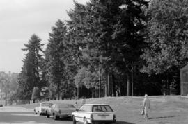
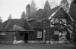
Connaught Park Field House, 2390 West 10th Avenue
Part of City of Vancouver fonds
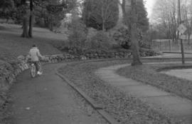
Almond Park, West 13th Avenue, street end
Part of City of Vancouver fonds

Memorial Park West - Lawn Bowling
Part of City of Vancouver fonds
Memorial Park West - Field House
Part of City of Vancouver fonds

Memorial Park, southwest corner - dry rock wall - Douglas Fir trees
Part of City of Vancouver fonds

Stanley Park - S.S. Beaver Tablet and Cairn
Part of City of Vancouver fonds

Stanley Park - President Harding Memorial setting
Part of City of Vancouver fonds

Stanley Park - President Harding Memorial, front
Part of City of Vancouver fonds

Stanley Park - President Harding Memorial, back
Part of City of Vancouver fonds

Grandview Park, looking south - wading pool - two Copper Beech
Part of City of Vancouver fonds

Thornton Park, foreground to Canadian National Railway Station
Part of City of Vancouver fonds

Stanley Park, Brockton Point Field House
Part of City of Vancouver fonds