
Carte particuliere de la cote du Nord-Ouest de l' Amerique reconnue par les fregates Francaises la Boussole et l'Astrolabe en 1786, 2e. feuille
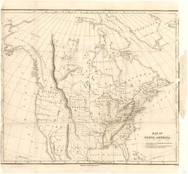
Map of North America

Map of a portion of British Columbia
![[Mrs. Benjamin Springer (nee Frances Nias)]](/uploads/r/null/c/a/ca224d65615780f4d8db5b187e45a1ca4c1fe491e81acf2c4b841e6883315c99/7464c91c-c001-4588-bfc5-f425b0f080dc-A34654_142.jpg)
[Mrs. Benjamin Springer (nee Frances Nias)]
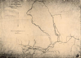
Sketch map of part of British Columbia showing trails and routes of communication

British Columbia

Sketch map of part of British Columbia showing trails and routes of communication
![[View of the Thompson River east of Lytton]](/uploads/r/null/b/5/b57bdc9554f4c089b187d1c5f5b233acbf931272e64dad2a0b54dd28040149cf/21978601-2e31-4d42-983f-3d601c619e55-A33843_142.jpg)
[View of the Thompson River east of Lytton]
![[A part of the Cariboo Road between Hell's Gate and Chapmans]](/uploads/r/null/0/9/09f564a5e10bf8b5b528d6cef608078781396fb613caaf73894b7adb3890e28a/20f81bdb-6c16-431f-a020-ec7dbd161749-A33841_142.jpg)
[A part of the Cariboo Road between Hell's Gate and Chapmans]
![[A part of the Cariboo Road]](/uploads/r/null/3/2/325b5ab94be7474ca99a4c6172efdaacbc096e5e7d14797a940ba9f1978735da/e943c3c1-170d-4b5c-a086-104eb24bb724-A33836_142.jpg)
[A part of the Cariboo Road]
![[A part of the Cariboo Road]](/uploads/r/null/0/4/0451742b8f917ab9edd6b6e459fc385a9414ee9989dcb46d1e7183d293552284/cd8f24b9-f274-4655-bd36-999be6a1c680-A33839_142.jpg)
[A part of the Cariboo Road]
![[Hill 19 on the Cariboo Road]](/uploads/r/null/a/7/a7b7a913e1e5325c312ae63d254ada4c643f0714061a8c4eae87d2593375f76d/c51b19f1-c3f8-4602-ab31-e440fec83226-A33838_142.jpg)
[Hill 19 on the Cariboo Road]
![[Nicaragua Bluff on the Cariboo Road]](/uploads/r/null/2/1/212ee267c1018cf936840d29525145920f13592d01c4166f02011afb7960667e/dfe8ff21-00f5-46e8-af64-5e05462e6164-A33842_142.jpg)
[Nicaragua Bluff on the Cariboo Road]
![[Cariboo road wooden bridge]](/uploads/r/null/6/8/68ce5215eae39e398be57511d2452aa8f265152be77a8b6ed651889e33f9a344/a7cf865a-d31b-4eda-b323-60e372cd7756-A24445_142.jpg)
[Cariboo road wooden bridge]
![[The Cariboo Road between Hell's Gate and Alexandra Bridge]](/uploads/r/null/c/a/ca92cca8713ae10c685a422d7a45a7ee840c766362394ef7ed5e775c28cc9de9/3335f8a1-c7b7-46ce-af78-7823f86b7b38-A33840_142.jpg)
[The Cariboo Road between Hell's Gate and Alexandra Bridge]
![[Mr. and Mrs. John Linn]](/uploads/r/null/f/1/f15ad8f20d26462863e1210e99859525f317649976c206b03ee09ddfaf34e067/e4883cff-d744-4d1a-ad4b-551fe1f88127-A61472_142.jpg)
[Mr. and Mrs. John Linn]
![[Barnard's Express and Stage Line with Royal Mail enroute to Barkerville ]](/uploads/r/null/8/f/8f1cd724a7ea0cb0754fe91d3bd553d4b5dbb3ea1b41d2cd9a46ae333ab72ea9/81e20b25-119d-4c84-8ffd-3bca5d2d1723-A37625_142.jpg)
[Barnard's Express and Stage Line with Royal Mail enroute to Barkerville ]
![[Hudson Bay Company's S.S. "Beaver"]](/uploads/r/null/e/8/e8a53b2741fa5f8533d9eba315b0638435205092f440bb0f46821f9d9efc9afc/105dcd63-9309-4438-bcb9-cfcb8ea3c65a-A23968_142.jpg)
[Hudson Bay Company's S.S. "Beaver"]
![[Five unidentified First Nations men]](/uploads/r/null/5/3/537bfb63d8e160f2acbb382b154bea91df35c24244eee0d6a24dfd0babccb41c/4e0527b8-4b9e-4d2c-9cc5-f5f0e21fffd7-A22896_142.jpg)
[Five unidentified First Nations men]
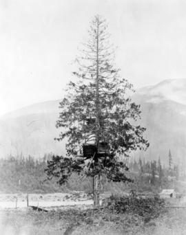
![Canoe Burial [in tree]](/uploads/r/null/1/b/1bdf9553ba481a9ab59e4d6fb0a0e818c422c700a3c909d293b789fc46d6baac/2fcc2d63-4341-40a6-867c-f9371b502e22-A26508_142.jpg)
Canoe Burial [in tree]

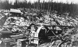
Gold Washing

On the Road to the Cariboo

Monumental Carvings

"Ne'er do well" claim, Cariboo
![[The Cariboo Road at Nineteen Mile]](/uploads/r/null/4/1/418b5bc66fd6c6308d93b02797fddf3bde764414fc361ca0b3480c9f1213aa23/a48be127-5cb2-454d-91a4-f5ac16d61091-A33950_142.jpg)
[The Cariboo Road at Nineteen Mile]
![[Unidentified native man]](/uploads/r/null/3/0/30529146abb9c0aacb0c8485080139afb3b8694e1fa973062903a8d46637ffc9/4ce76977-2fa8-41ae-9b70-1ba34bd5613e-A26504_142.jpg)
[Unidentified native man]

Stoats Gulch Claim

Fort Rupert Indian
![Songish [Songhees] group V.I.](/uploads/r/null/5/a/5a6efcef723d7560efb8f2101502fecba70c19156e4f0e98341b0b7c63d7a0be/11a1a9ba-f49a-444d-98af-d5de5ec3dcef-A26502_142.jpg)
Songish [Songhees] group V.I.
![Indian Chief's Grave [in the Fraser Canyon, B.C. near Lytton B.C.]](/uploads/r/null/6/5/652f602db9758553ddbc4c37aca02c40aab2890ca4f3a3891d1e1ecb23a57187/6a2fd72f-73bb-4f43-8d50-6f0be0035dcb-A26510_142.jpg)
Indian Chief's Grave [in the Fraser Canyon, B.C. near Lytton B.C.]

Crossing Ferry
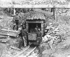
Gold Mine
Salmon Cache

Washing Gold
Aurora Claim

Salmon Cache

Indian burial
![Gold diggings [on] Leach River, B.C.](/uploads/r/null/b/2/b29a5a2036a5bb83a50855637173e96f3105c432c53f7491a5e10a36d2516566/cf36bdd2-cbcd-430e-9487-f3eef153e008-A33820_142.jpg)
Gold diggings [on] Leach River, B.C.

Williams Creek Claim
![[Studio portrait of unidentified First Nations Woman in European-style clothing]](/uploads/r/null/c/f/cf11f0c4bfbbb5eac2feb54623e30aa4980c1e022474fce717a5a9fbd73933fd/2f2db698-95d1-49ea-9889-fe35db48bfcf-A22897_142.jpg)
[Studio portrait of unidentified First Nations Woman in European-style clothing]
![[Studio protrait of an unidentified First Nations man]](/uploads/r/null/c/f/cfa04a7d3ec559b6eaed021b24024838b3c10fa480c3d5fcf685c6284ef7b454/5f97521f-f439-4ef5-b94d-3c9f522be313-A22889_142.jpg)
[Studio protrait of an unidentified First Nations man]
![[Unidentifed First Nations man]](/uploads/r/null/c/2/c2a431c7c4c44e23ff5183d28e0e55c903a8155f203b90d455f5917f5a414b31/5c47770a-7ca0-45a6-be0e-51680e5e9e24-A22905_142.jpg)
[Unidentifed First Nations man]

Deadman's Island - Vancouver Island
![H.M. Ship "Chanticleer" [in Esquimalt harbour, Vancouver Island]](/uploads/r/null/4/7/477d57b381497480e2fc96b3ff9f2a5b880f1c0b9c659e5d876bafc40b05cef9/1d63151b-557e-4e32-9a47-7548d15ebcb3-A22854_142.jpg)
H.M. Ship "Chanticleer" [in Esquimalt harbour, Vancouver Island]
![[Hugh McRoberts]](/uploads/r/null/d/5/d5d4316e30c9561b0947b134e622471b824cfc0885afc898324eca1c1166e8f0/d1910833-a3be-47df-8490-506b55c50e9a-A61987_142.jpg)
[Hugh McRoberts]
![[Phillip Sullivan]](/uploads/r/null/2/2/22125fe7e955b8ecc888c2caebc058031383e9c5d422af0de2f9e32d99970f1d/5fb35d4d-7cb1-4940-99b0-8f1b1eed6766-A35099_142.jpg)
[Phillip Sullivan]

The wagon road at the 17 mile post - road to Goldfields

Admiral Hastings and Hans
![China Bluff on way to Boston Bar - Frazer [Fraser] River](/uploads/r/null/7/b/7bd123659bbb4dc0aa3970fe573df39cbf2f6b12f7e5747300a89968847289cf/51f452e5-0b09-4380-a408-9ad604c969d5-A22917_142.jpg)
China Bluff on way to Boston Bar - Frazer [Fraser] River
![[Studio portrait of an unidentified First Nations man]](/uploads/r/null/2/b/2b2b97bc28f0ca3e7b3e5e8ce4663ec0824ed6b35c5c9e3253d512248f3c1a7b/e55ba3b7-b8fb-427d-b9ba-b55a3f8adf53-A22890_142.jpg)
[Studio portrait of an unidentified First Nations man]