- COV-S397---: LEG1362.02
- Item
- Nov. 10, 1926
Part of City of Vancouver fonds
Part of City of Vancouver fonds
Part of City of Vancouver fonds

Part of City of Vancouver Archives technical and cartographic drawing collection
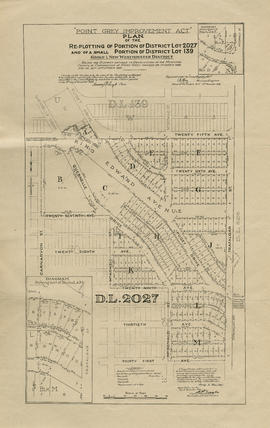
Item is a map showing major streets, lot numbers, lot boundaries and property sold or reserved in the area from Chaldecott Road (now King Edward Ave.) in the north to Magee Road (now W. 49th Ave.) in the south. Kaye Road (now Trafalgar St.), Wilson Road (now W. 41 Ave.), Bodwell Road (now W. 33rd Ave.) and Johnson Road (now Blenheim) are all included on the map.
![Plan of Point Grey Municipality [ward boundaries]](/uploads/r/null/a/c/a/aca691b3d6e49d092070fc230a88f5ca7bd346fc8c5894892d7cdc5a79b535ee/9a14b192-1858-43aa-ab28-d0b03a2304eb-MAP360_142.jpg)
Plan of Point Grey Municipality [ward boundaries]
Part of City of Vancouver Archives technical and cartographic drawing collection
Item is a copy of a commercially published map of Point Grey which has been used as a base map to depict existing and proposed new ward boundaries for Point Grey municipality.

Plan of government subdivision at Point Grey, B.C.
Part of City of Vancouver Archives technical and cartographic drawing collection
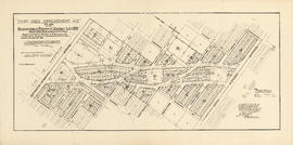
Item is a sheet which has been excised from the Journal of the Town Planning Institute, December 1925 issue. The sheet consists of two street layout plans and an illustration. The street layout plans show current and proposed revised street layouts for the area of Point Grey bounded by Highbury Street, Eighth Avenue, Imperial Street, and Tenth Avenue. The illustration depicts the view north from the proposed development area.

Lot numbers, boundaries, railway lines and street names in the municipality of Point Grey
Part of City of Vancouver Archives technical and cartographic drawing collection
Primary map shows lot numbers, boundaries, railway lines and street names in the municipality of Point Grey from 16th Avenue in the north to the Fraser River in the south and from Ontario Street in the east to Blanca Drive in the west. A smaller map in the bottom left-hand corner of the item shows the north west portion of Point Grey.