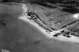
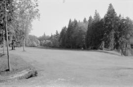
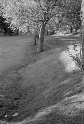
![[A miniature golf course at the corner of Cardero Street and Georgia Street]](/uploads/r/null/8/8/88c09b61185ffb5d86a519d1e43df57d72e11ae07333c27464bd9b5577b8655c/84c1a393-5935-41fa-ab3b-be8075ede568-A36594_142.jpg)
[A miniature golf course at the corner of Cardero Street and Georgia Street]
- AM54-S4-: Sp P69
- Item
- 1930 ; reproduced 1955
Part of Major Matthews collection
[A miniature golf course at the corner of Cardero Street and Georgia Street]
Part of Major Matthews collection
![[Aerial view from helicopter] - Shaughnessy Golf Club House](/uploads/r/null/5/d/5/5d5d8792969484ccece23357dbd8823275df30c087900509f9ad9548c867dd0d/09e33ad9-ff16-4e4b-9552-5a181fd0d2dc-CVA160-23_142.jpg)
[Aerial view from helicopter] - Shaughnessy Golf Club House
Part of William Orson Banfield fonds
![[Aerial view of Burrard Inlet, Hastings-Sunrise, Burnaby and the District of North Vancouver]](/uploads/r/null/d/f/df7e11c97173ce0473c454f0a01569b641972f6efdc12bf192edbc42119542d6/6d72f89b-9b55-48c4-bef6-04eb2137f1d3-A66600_142.jpg)
[Aerial view of Burrard Inlet, Hastings-Sunrise, Burnaby and the District of North Vancouver]
Part of Major Matthews collection
Photograph shows Exhibition Park and P.N.E. Golf Course, Second Narrows Bridge, New Brighton Park, Callister Park, Burrard Inlet, Lynn Creek, Lynn Park, Seymour Creek, Vancouver Harbour Commissioners Railway, Inspected Shingles Ltd., Cascade Rock and Gravel Co. Ltd., Canadian Shingle Co. Ltd. (Capilano Timber Co. Ltd.), Alberta Pool Elevator, Columbia Grain Elevator Co. Ltd., Canadian Pacific Railway, Girls Industrial School and Old Peoples Home sites.
![[Aerial view of Vancouver]](/uploads/r/null/b/9/b973b9a4143a5316b02e728c35d99e383f27a3db21d8e20aa7bbb459780243bc/3ff38b56-6b36-4c17-bce1-329c97459d29-A66598_142.jpg)
Part of Major Matthews collection
Photograph shows Kitsilano, Kits Point, Kitsilano Beach, R.C.A.F. Equipment Depot, Kitsilano Pool, Burrard Bridge, C.P.R. Kitsilano Trestle, Granville Island, Granville Bridge, Cambie Bridge, False Creek, C.P.R. False Creek Yards, West End, Yaletown, Arbutus Ridge, Shaughnessy, South Cambie, Fairview, Mount Pleasant, Little Mountain Reservoir, Connaught Park, Quilchena Golf Course, Douglas Park, Shaughnessy Heights Golf Course, Queen Elizabeth Park, Royal Canadian Mounted Police Barracks, Shaughnessy Military Hospital, Hillcrest Park, Robertson & Hacket Sawmill, City Yard, West Coast Ship Builders and Athletic Park.
![[Aerial view of West Point Grey, Kitsilano, Dunbar - Southlands and University Endowment Lands]](/uploads/r/null/0/8/089d213e9a81ca689130a244122a86972e068c9b01ab994922a88072ac881121/1ed71859-c157-4686-82db-e3483cd4b877-A66599_142.jpg)
[Aerial view of West Point Grey, Kitsilano, Dunbar - Southlands and University Endowment Lands]
Part of Major Matthews collection
Photograph shows the south Slope of English Bay, Spanish Banks, Locarno Beach Park, Jericho Beach, R.C.A.F. Jericho Air Station, Kitsilano pool, Connaught Park and Kitsilano Beach Park, Caldecott Park, Quilchena Golf Course, School for Deaf and Blind and Quesnel Park.
Part of Major Matthews collection
Oblique view showing the R.C.A.F. Jericho Air Station, the Jericho Golf Course, Locarno Beach, a boathouse, the Canadian Life Saving Association building and the houses at the foot of Imperial (Discovery) Street
Part of Major Matthews collection
Photograph shows an oblique view of R.C.A.F. Jericho Air Station at Locarno Beach and the Jericho golf course
Part of Major Matthews collection
Photograph shows an oblique view of R.C.A.F. Jericho Air Station at Locarno Beach, Jericho golf course and Imperial (Discovery) Street
Part of City of Vancouver Archives sound recording and moving image collection
Item is a promotional film for the British Properties Limited, Capilano Estates containing title cards. The film shows the properties including houses, the golf course, the tool house, the club house and surrounding landscape. The film also shows the clearing of land by British Properties.

Part of City of Vancouver Archives technical and cartographic drawing collection
Map is a City Engineering Department base map of Vancouver, showing city blocks and Canadian Pacific, Canadian National and Great Northern Railway lines. Parks, golf courses, hospitals, schools, theatres and other structures are identified. "Metric Vancouver" and "Guide Map 15" appear in the bottom right corner of the map.

Part of City of Vancouver Archives technical and cartographic drawing collection
Map is a City Engineering Department base map of Vancouver, showing city blocks and Canadian Pacific, Canadian National and Great Northern Railway lines. Parks, golf courses, hospitals, schools, theatres and other structures are identified. "Guide Map 15" appears in the bottom right corner of the map.
![City of Vancouver [park sites June/80]](/uploads/r/null/9/4/9484add7c4684ea3838e4d00ee8add3ecf85d78d5aa8fe2780cae273e59556a5/bd2464d8-2aa9-4501-aba6-8b3f7d130a42-MAP1032_142.jpg)
City of Vancouver [park sites June/80]
Part of City of Vancouver Archives technical and cartographic drawing collection
Map is a City Engineering Department base map of Vancouver, with parks hand-coloured in green. Shows city blocks and Canadian Pacific, Canadian National and Great Northern Railway lines. Golf courses, hospitals, schools, theatres and other structures are identified. "Metric Vancouver" and "Guide Map 15" appear in the bottom right corner of the map.

City of Vancouver, British Columbia
Part of City of Vancouver Archives technical and cartographic drawing collection
Item is the western half of a map showing city blocks, transportation infrastructure, recreational facilities, hospitals, schools, theatres and other structures are identified. MAP 1036 is the eastern half of this map.
Vancouver (B.C.). Engineering Services

City of Vancouver, British Columbia
Part of City of Vancouver Archives technical and cartographic drawing collection
Item is the eastern half of a map showing city blocks, transportation infrastructure, recreational facilities, hospitals, schools, theatres and other structures are identified. MAP 1036b is the western half of this map.
Vancouver (B.C.). Engineering Services

City of Vancouver, British Columbia : co-ordinate street index map 12
Part of City of Vancouver Archives technical and cartographic drawing collection
Map is City Engineering Department base map 149 of the City of Vancouver, showing city blocks, streets and railway lines, as well as the area code co-ordinates assigned by the department. Golf courses, hospitals, schools, theatres and other structures are also identified.

Part of City of Vancouver fonds

Fraserview Golf Course, Field House
Part of City of Vancouver fonds

Fraserview Golf Course, Field House
Part of City of Vancouver fonds
Golf - B.C. Amateur Championships
Part of Stuart Thomson fonds
Negative envelope notes that the championship is on the Quilchena Golf Course.

Historical : original appearance, Shaughnessy golf course

Historical : original site, Shaughnessy Golf Course
Historical : Shaughnessy golf course

Part of Major Matthews collection
Photograph shows an oblique view
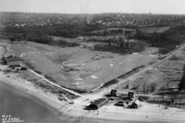
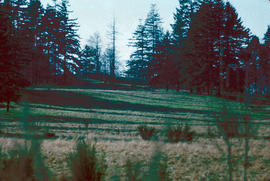
![[Land being cleared for the Shaughnessy Heights Golf Club]](/uploads/r/null/c/f/cfd21ea2d3777879cf1f21ddde4d3f72ea9c19e0afad7558b39aedab6547dce0/6d3cf00d-0514-4067-bec7-eb305ec3696a-A25885_142.jpg)
[Land being cleared for the Shaughnessy Heights Golf Club]
Part of Major Matthews collection
Photograph shows area where stream believed to flow

Langara Golf Course - Field House, front
Part of City of Vancouver fonds

Langara Golf Course - Field House, side
Part of City of Vancouver fonds
![[Man playing golf at Shaughnessy Golf Links]](/uploads/r/null/e/5/e5ab27386d2175192396454ba885477ce6aac5417744ba6e9f809919ef90aac7/a116d4cf-9121-4c48-ae68-2281ac98f3d3-A09376_142.jpg)
[Man playing golf at Shaughnessy Golf Links]
Part of Major Matthews collection
![Marine [Drive] Golf and Country Club](/uploads/r/null/2/2/22dd7d67e047d71c0f207458004881b05bf22a940c8bddaaa2db847cb332fbf4/a7febf44-080b-476f-8dcf-0db0ea97ca43-A17196_142.jpg)
Marine [Drive] Golf and Country Club
Part of Stuart Thomson fonds
![[Men playing golf at Hastings Park Golf Links]](/uploads/r/null/2/9/29f921cc89582ad32eeff34e7139a01bf47fc0d0310f8b3b318a8b2d8be333cc/d8f4617e-f907-4d71-8fa6-8cde4c7a0280-A09372_142.jpg)
[Men playing golf at Hastings Park Golf Links]
Part of Major Matthews collection
![[Men playing golf at Hastings Park Golf Links]](/uploads/r/null/6/4/648ace08b5e7df9132ba62a483dd79429e3d1d6f7a4feb64ad528ae63e6e3ad6/6faf8004-ffdc-43ce-a7bf-3d4063400c81-A09371_142.jpg)
[Men playing golf at Hastings Park Golf Links]
Part of Major Matthews collection
![[Men playing golf at Shaughnessy Golf Links]](/uploads/r/null/b/1/b11ebd4b18296c330355054fb770add8467e2b8618c639ad27a1394cbbbcf6d7/ab803656-a105-4582-a4e0-5121501c862d-A09375_142.jpg)
[Men playing golf at Shaughnessy Golf Links]
Part of Major Matthews collection
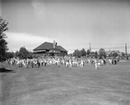
![Park tour, opening [of] Q.E. [Queen Elizabeth] Golf Course](/uploads/r/null/9/b/0/9b03903c0ebb9e780c8cd7c58f301b8aa5779b09c280a237f3449b86ff8e2dc2/0bb3eb60-3325-4ebf-8437-c5c231cc993a-CVA289-161_142.jpg)
Park tour, opening [of] Q.E. [Queen Elizabeth] Golf Course
Part of William Orson Banfield fonds
![Park tour, Q.E. [Queen Elizabeth] Golf Course, first tee](/uploads/r/null/8/0/e/80e8d33d2645f41523fe8323b58c9b25b223a861a922b4ffae5dfd3ac40100ab/cdb524b6-3fd1-4bb4-8f7c-6d3ac58314b6-CVA289-169_142.jpg)
Park tour, Q.E. [Queen Elizabeth] Golf Course, first tee
Part of William Orson Banfield fonds
![Park tour, Q.E. [Queen Elizabeth] Golf Course, Rathie tees off](/uploads/r/null/8/5/a/85a5339734dd25c50dbd465a7cfd9712a78cb9c082b4a3f6bcd8579937b2103b/201cb627-30de-444c-af30-5a7acfaf28ad-CVA289-162_142.jpg)
Park tour, Q.E. [Queen Elizabeth] Golf Course, Rathie tees off
Part of William Orson Banfield fonds
![Park tour, Q.E. [Queen Elizabeth] Golf Course, the first ball](/uploads/r/null/c/5/2/c5232d7cb6a179549691c53a6d57cdb149c692be5d65a74aa5070f5a86b82c15/e21407c2-255e-4ef5-92da-df56d829cc99-CVA289-168_142.jpg)
Park tour, Q.E. [Queen Elizabeth] Golf Course, the first ball
Part of William Orson Banfield fonds
![Park tour, Q.E. [Queen Elizabeth] Golf Course, Wainburn tees off](/uploads/r/null/3/1/6/31684c8eff04796ee32b4683e4de074e681a0ce6d2c96bdb62331b8c9d6e8bc3/f198013b-364f-4855-be3b-83f4c4ae71ee-CVA289-163_142.jpg)
Park tour, Q.E. [Queen Elizabeth] Golf Course, Wainburn tees off
Part of William Orson Banfield fonds
![Park tour, Rathie opening Q.E. [Queen Elizabeth] Golf Course](/uploads/r/null/1/c/8/1c888f5633fda80137cbbe8d41214d8c3652c0b661778542d13800b6a6444826/778abd4f-e53e-4bb6-a4b0-d9a49b0d1706-CVA289-164_142.jpg)
Park tour, Rathie opening Q.E. [Queen Elizabeth] Golf Course
Part of William Orson Banfield fonds
![Park tour, Rathie opening Q.E. [Queen Elizabeth] Golf Course](/uploads/r/null/5/0/7/507b65bb2c74e4090f9019b641f0a106def4dbcf372873456ae18765557d0f0b/e1ceb1e9-1e6a-4093-8a54-e959a6139e72-CVA289-165_142.jpg)
Park tour, Rathie opening Q.E. [Queen Elizabeth] Golf Course
Part of William Orson Banfield fonds

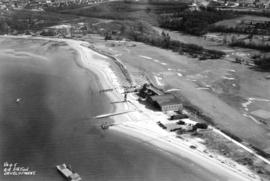
Pee Wee Golf Course - Cardero Street and Georgia Street
Part of Stuart Thomson fonds
![[Shaughnessy Golf Links fairway]](/uploads/r/null/2/5/2542348b5679ef2560e33894313187273ac862e96ed53528df5161d5e46a7fc7/148fd6b7-c64b-4d02-8556-9706faa6308d-A09377_142.jpg)
[Shaughnessy Golf Links fairway]
Part of Major Matthews collection

Sheet 11 : Cambie Street to St. George Street and Forty-seventh Avenue to Fifty-eighth Avenue
Part of City of Vancouver fonds
Item is a section showing the area from Cambie Street to St. George Street and Forty-seventh Avenue to Fifty-eighth Avenue. Includes streets, roads, blocks, lots, legal descriptions, golf courses, parks and schools. Map is hand coloured to show tax sale property for sale, property with no water, street widening and drainage, replotting, reserved land for schools, reserved land for parks, sundry land, capital assets not including schools and parks, schools, and parks, as applicable.
Vancouver (B.C.). Office of the City Engineer

Sheet 11 : Cambie Street to St. George Street and Forty-seventh Avenue to Fifty-eighth Avenue
Part of City of Vancouver Archives technical and cartographic drawing collection
Item is a section showing the area from Cambie Street to St. George Street and Forty-seventh Avenue to Fifty-eighth Avenue. Includes streets, roads, blocks, lots, legal descriptions, golf courses, parks and schools.
Vancouver (B.C.). Office of the City Engineer

Sheet 17 : Argyle Street to Vivian Street and Sixty-second Avenue to Kent Street
Part of City of Vancouver fonds
Item is a section showing the area from Argyle Street to Vivian Street and Sixty-second Avenue to Kent Street. Includes streets, roads, blocks, lots, legal descriptions and golf courses. Map is hand coloured to show tax sale property for sale, property with no water, street widening and drainage, replotting, reserved land for schools, reserved land for parks, sundry land, capital assets not including schools and parks, schools, and parks, as applicable. "22, 23, 25 to 33, 35, 36/258-329" is written in ink at the top of the map.
Vancouver (B.C.). Office of the City Engineer

Sheet 17 : Argyle Street to Vivian Street and Sixty-second Avenue to Kent Street
Part of City of Vancouver Archives technical and cartographic drawing collection
Item is a section showing the area from Argyle Street to Vivian Street and Sixty-second Avenue to Kent Street. Includes streets, roads, blocks, lots, legal descriptions and golf courses.
Vancouver (B.C.). Office of the City Engineer

Sheet 18 : Vivian Street to Boundary Road and Sixty-fifth Avenue to Fraser River
Part of City of Vancouver Archives technical and cartographic drawing collection
Item is a section showing the area from Vivian Street to Boundary Road and Sixty-fifth Avenue to Fraser River. Includes streets, roads and railway lines; blocks, lots and legal descriptions; and parks, schools and golf courses.
Vancouver (B.C.). Office of the City Engineer
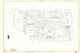
Part of City of Vancouver Archives technical and cartographic drawing collection
Item is a sectional map of a portion of Vancouver showing the area from Musqueam Indian Reserve to Balaclava Street and Forty-ninth Avenue to Forty-first Avenue. Includes streets, blocks, lots and legal descriptions, and the locations of schools, parks and golf courses.

Sheet 66 : Musqueam Indian Reserve to Balaclava Street and Forty-ninth Avenue to Forty-first Avenue
Part of City of Vancouver Archives technical and cartographic drawing collection
Item is a section showing the area from Musqueam Indian Reserve to Balaclava Street and Forty-ninth Avenue to Forty-first Avenue. Includes streets, blocks, lots and legal descriptions, and the locations of schools, parks and golf courses.
Vancouver (B.C.). Engineering Services