Item is a copy of a Planning Department map of downtown Vancouver. This copy has a mylar overlay which masks the area north of Georgia Street between Bidwell and Chilco Streets.
Item is a map that would have been created to accompany an application for re-zoning for Block 235 D.L. 538 and water lots 5834, 5601 and 5600. It appears that this application failed, as no amendment to By-law 3575 for these properties has been found.
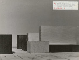
Item consists of a photograph depicting a model created by Planning Department staff to study view obstructions which result from various building configurations, based on different options to be included in zoning regulations for the West End.
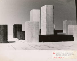
Item consists of a photograph depicting a model created by Planning Department staff to study view obstructions which result from various building configurations, based on different options to be included in zoning regulations for the West End.
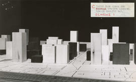
Item consists of a photograph depicting a model created by Planning Department staff to study view obstructions which result from various building configurations, based on different options to be included in zoning regulations for the West End.
Item consists of a photograph depicting a model created by Planning Department staff to study view obstructions which result from various building configurations, based on different options to be included in zoning regulations for the West End.
Item consists of a photograph depicting a model created by Planning Department staff to study view obstructions which result from various building configurations, based on different options to be included in zoning regulations for the West End.
Item consists of a photograph depicting a model created by Planning Department staff to study view obstructions which result from various building configurations, based on different options to be included in zoning regulations for the West End.
Item consists of a photograph depicting a model created by Planning Department staff to study view obstructions which result from various building configurations, based on different options to be included in zoning regulations for the West End.
Item consists of a photograph depicting a model created by Planning Department staff to study view obstructions which result from various building configurations, based on different options to be included in zoning regulations for the West End.