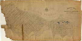
Contour plan of a portion of the City of Vancouver
- COV-S365-: MAP 715
- Item
- Aug. 26, 1889-1913
Part of City of Vancouver fonds
Item is a map of the area from Chilco Street to Raymur Avenue and Coal Harbour/Vancouver Harbour to False Creek showing topographic contour lines, streets, block numbers (in Roman numerals), sewers, manholes, and elevations at various points along streets.
![Davie & Granville [after heavy snowfall]](/uploads/r/null/9/5/957a5cb72e66af500c4a5348592f923ed6d5231c93ae0eb0929df0f007d44f61/6a9458e8-2283-4d5d-b455-8aa0e5367350-A16575_142.jpg)
![[Hastings and Richards after heavy snowfall]](/uploads/r/null/e/9/e9d02bd659129635b1478a4fc6e9bf0c9cd8498067eba2c1fb866a9d52e3db0d/8d97b4f0-d8ea-43e9-a1e1-bbdd77d4f1ba-A16577_142.jpg)
![[600 block Hastings St. W. after heavy snowfall]](/uploads/r/null/1/e/1e87b92ddb583d44c61d56889b5e305648cf593c9a1dd564c5f68991f9d48398/5fc1063f-3fc6-43ed-835d-539dd82a3927-A16578_142.jpg)

![[Pender Street at Cambie Street, looking west]](/uploads/r/null/3/d/3d91c3d4cd2181022a308d60e8fad6da587efcfa17cc0a68527eb95c215bc009/5a8ff240-1741-4881-b137-7b3a66b98a1d-A43705_142.jpg)
![[Granville St. at Hastings St., looking south]](/uploads/r/null/a/2/a2b150fdc2d0d1091b88dcb4036e315291c2712f91faf805ab8ed329a1a56990/cd90450d-d6b2-45e1-8810-c58b313df506-A43716_142.jpg)
![[Granville St. at Hastings St., looking south]](/uploads/r/null/3/f/3f5c9c270d59846d9552f5e5c9c93dd128d30ad0698afa539c75b12d1c38afc0/93642b9d-f977-478f-9940-f53ece9cdca0-A43717_142.jpg)
![[700 E Hastings St]](/uploads/r/null/e/d/ed03592c91e746bd2bdb2f7bd19463f38d2315e8700fb0347925fabcb17aa532/ca970500-4326-4da5-bcd5-c6553ee5fda4-A43723_142.jpg)
![[Looking north from Hastings Street along Hawkes Avenue]](/uploads/r/null/c/6/c6b7721c67508d95616838456d2e6f7fcb948b0917845c03dd2885e884026c85/090e0d28-920a-4794-bafe-7ce84481a5d2-A43725_142.jpg)


![Abbott and Cordova [streets looking] west](/uploads/r/null/9/e/9e6ecc370bc289e5be80f2c7024a559ad55f83ec49ec64c8f3a8df89481637f7/f7d058c6-cc09-4ac7-85bf-be6f0d56c87c-A42713_142.jpg)
![Abbott and Hastings [streets looking] east](/uploads/r/null/f/a/fa0d67515affc3ab9a0a5625d6d6d6e103e07a6f1a5d936f025bfd1d86416738/bf20e84f-2d2c-4ba3-a778-dfd77978f715-A42715_142.jpg)
![Abbott and Hastings [streets looking] west](/uploads/r/null/1/a/1a3c9bdca5e9a05a681433abe9fe739bf52e86440936b967e1a49e5ea06628b0/99dd753a-1f99-4729-89d6-21b755a5eeb1-A42717_142.jpg)
![Abbott and Pender [streets looking] east](/uploads/r/null/f/8/f83eaf09fec1ebf23e21a3db3691921915705e4f383ef44a5027be0102269396/3566daa7-37b0-43c3-96e2-f30d512ad817-A42719_142.jpg)
![Abbott and Pender [streets looking] south](/uploads/r/null/b/b/bb5e90c611916f1b8ac5bbd1c7756bb79e72acbd41bf494dd418f633f3c49dca/284f1b6d-4e1e-4720-966f-571e057fc42c-A42720_142.jpg)
![Alder and 6th. [Avenue looking] north](/uploads/r/null/b/5/b5e8014aa997d96e6cbf92700ea83aa8dc54d72042b05322e9852ba8ceff9488/44a9a5d1-bf83-4a5b-81ab-2a25d3fa29eb-A42722_142.jpg)
![Alder [Street] and 6th [Avenue looking] south](/uploads/r/null/a/e/ae393bfbc80a207f68cd15f0f0b40ecc6636b45191de8f943d48ac6dfb55edf6/a8b1130e-2354-4236-8727-50a9e570eb1b-A42724_142.jpg)
![Alma [Street]and Broadway [looking] east](/uploads/r/null/a/f/afd0dff1de21eae47f3b74fc927c36b4de2199db612635f05b427be03980332c/786e1118-45c9-4bea-8ef1-6a645e4399fe-A42727_142.jpg)
![Arbutus [Street]and Broadway [looking] west](/uploads/r/null/1/c/1c154e16860abca1b1731a016ff1f47221886c1bffd8f2461dcbe97f190e6361/85b0dcdd-fd8c-440f-b4e0-f93e4496909f-A42741_142.jpg)
![Arbutus [Street] and King Edward [Avenue looking] south](/uploads/r/null/e/d/edc02b3139d00083bde54dcea330b4cb36d7363ddff8990c27aa0ccfec1c20bc/91d3ba5a-f0d0-441a-8114-61d47b53bb64-A42745_142.jpg)
![Arbutus [Street] and 4th [Avenue looking] north](/uploads/r/null/9/c/9cb97b309f5c18e106904708a9870a5279e4301dd65da7f40bfa461463a5d1e6/64eef3c5-1c63-43df-899d-8ec9c0c992be-A42747_142.jpg)
![Arbutus [Street] and 12th [Avenue looking ] north](/uploads/r/null/c/f/cf6f850e40c141e821d9e014b4ddee4937e1b09b34a20fdb0ae865ad2947d2f2/f1cee902-de5f-47ae-9c97-ed071446ff24-A42751_142.jpg)
![Arbutus [Street] and 33rd [Avenue looking ] north](/uploads/r/null/9/1/91f9f25f8119fadeffe1aa8512f61455f0a0814d9f48640c611976a0180bb261/13586cbc-ca69-41b0-b8e5-fafbfd560217-A42758_142.jpg)
![Ash [Street] and Broadway [looking] west](/uploads/r/null/7/4/74fc374d592b2621cb36b16b4b437fb2a4101d3438f608ced8d126feec73a9b4/e8a1c81e-f823-4514-8880-8e7c5d10503f-A42764_142.jpg)
![Balsam [Street] and 4th [Avenue looking] north](/uploads/r/null/4/8/4882131535a88ee9df23fc6a6437693220965ec5f0d07b92050b35e913bbda61/7fe40878-0f41-4db8-a64c-fd858ec86b71-A42767_142.jpg)
![Beach [Avenue] and Thurlow [Street looking] east](/uploads/r/null/e/5/e5b61776b0dd209e0887c02fcdeeb1c32e0ebac285911f6d3242d0c27c88493c/2d3c6834-2720-4958-8010-c2abde712334-A42769_142.jpg)
![Beach [Avenue] and Thurlow [Street looking] south](/uploads/r/null/9/6/96e7337172a52f59441f7616df843308b63d05ecae16c5cd6e504942c8057ee4/7080b4d3-274e-43eb-b706-ca19f3ef2759-A42772_142.jpg)
![Beatty [Street] and Dunsmuir [Street looking] south](/uploads/r/null/f/3/f3e026c5836dbe57684fe5804572824fda0c1f9a299699453fab236dfbdd3633/3ed3f08d-6c17-4ad9-9034-1f2e3f90ec59-A42775_142.jpg)
![Beatty [Street] and Dunsmuir [Street looking] south](/uploads/r/null/4/e/4e280fce02bf4c72e76fede66887bed027c30bce4501ba219a0b1c20414a32d1/e075e7b8-d5d5-4f52-9906-0614e01fbd5a-A42777_142.jpg)
![Beatty and Pender [streets looking] east](/uploads/r/null/2/6/26d405c9c939f2817e6dde2b8b16571e6afb6e3f633a5bd12e0dd60f967eb068/11be29e6-4390-4450-89db-6c78b862f3b4-A42781_142.jpg)
![Beatty and Robson [streets looking] west](/uploads/r/null/d/c/dc0a5acd657f25e571459882470de4b8976074155c1ac45790ed995de9ae22a8/1e714fbc-4f15-4bd6-9f9b-4ecff43e6da4-A42786_142.jpg)
![Beatty and Robson [streets looking] north](/uploads/r/null/0/5/056d09cb51b60f583677a57a5e0b30c11e7dc02b0fdee2d896cd7b8d6da0d708/bd729661-d300-43ae-b6f1-9b6fe0e81dfc-A42788_142.jpg)
![Blanca [Street] and 10th [Avenue looking] east](/uploads/r/null/9/e/9e409c479f6dd9cb270527f23c0fb96ef336380da64cf3bf28ba07479355f378/a1a5b93f-f262-48f2-8dcc-28b65fbefb85-A42793_142.jpg)
![Blanca [Street] and 10th [Avenue looking] north](/uploads/r/null/5/b/5b433c782e1f95dfd9d060314971cc23a6fb54b1025426a4fb8e15dde4ffcd83/8056d802-18b0-40a2-937e-e43f26f1c1cb-A42794_142.jpg)
![Blanca [Street] and 4th [Avenue looking] west](/uploads/r/null/f/0/f060307245ba3320a9f396008d05981d732a720a418b984ebc9e09548249dd86/955cb32b-9f04-4596-90b2-4c6958dc93f1-A42795_142.jpg)
![Blanca [Street] and 4th [Avenue looking] north](/uploads/r/null/b/7/b70ded6bb2e480fe9bd36b40a68cd3f3d5e19fd0a144070e715c2647c3d0c988/b47cea13-e48c-4489-9f89-29c04c66ab21-A42796_142.jpg)
![Blanca [Street] and 4th [Avenue looking] south](/uploads/r/null/f/f/ffcffe03eb47360d3ee00f0c3183700a057242b0f0ec32fc9bc864d04d088fa7/3a95f3be-2973-4098-912e-b8cd1abdaaca-A42798_142.jpg)
![Blanca [Street] and 16th [Avenue looking] south](/uploads/r/null/f/d/fd43455cdab884ea06a50f19ae99912b67a04d25593ac8a3f732fcb1883480d1/9d82724c-2cd5-4e74-a712-61798d92d84b-A42802_142.jpg)
![Blenheim [Street] and Broadway [looking] east](/uploads/r/null/b/1/b1cba4e5127f54f483476739d222aad4c08c63d879c7873db15453a8387f9487/92ed85ea-c419-48c6-bd8c-b979f7e4e4bd-A42803_142.jpg)
![Blenheim [Street] and Marine [Drive looking] west](/uploads/r/null/1/9/1946b7fbc6eab73299d6746480b9d9a30c0ba298525cfe22da939618fffab63c/a7f4bebd-f0f1-4ab8-8fa8-cb9454343b87-A42806_142.jpg)
![Blenheim [Street] and Marine [Drive looking] east](/uploads/r/null/2/7/27e292f91c57d833dc13e26dc025cf85f09b995bf2dae82b963a7b9d47e6200c/e57011c8-0313-4b56-9f6d-9113aba3a404-A42808_142.jpg)
![West Boulevard and 41st [Avenue looking] north](/uploads/r/null/6/4/64b95cdd8554eee92368a9ea42fb038b2399a0f0b8fcf1e07da1db1c5d391647/2e12e492-7246-4f80-b0f6-dba14e2f51da-A42810_142.jpg)
![West Boulevard and 41st [Avenue looking] south](/uploads/r/null/3/d/3d75433f0f069a68863b65c4a255e965005ba47fbdf47b86eb6ec3444fb82100/889bc845-ab7a-4e44-8878-641e55970fc2-A42812_142.jpg)
![West Boulevard and 41st [Avenue looking] west](/uploads/r/null/4/b/4bc4d82036fd8d0cdd75e7eed147159cf2f2f626c12b172886c1eed327845a81/0fe2db94-0b94-4a02-a960-e2188a4472f1-A42813_142.jpg)