
- AM1594-: MAP 1059
- Item
- 1968
Part of City of Vancouver Archives technical and cartographic drawing collection
Item is a map in the form of an aerial photograph which has been annotated to show landmarks, tourist sites and trails in Stanley Park.
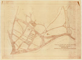
Part of City of Vancouver Archives technical and cartographic drawing collection
Item is a map in the form of an aerial photograph which has been annotated to show landmarks, tourist sites and trails in Stanley Park.
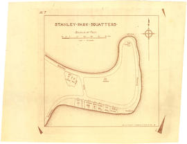
Part of City of Vancouver Archives technical and cartographic drawing collection
Item is a copy of a map showing a portion of Stanley Park and parcels of land labelled with surnames of identified squatters.
![Stanley Park [Golden Jubilee]](/uploads/r/null/2/4/24135e2d726e60ffbc74f0d81c3a53d51a38fe9ea1e86ecda92708249adac23b/1b46df5d-6871-41b2-b1dd-91a0c1d5ad02-MAP624_142.jpg)
Part of City of Vancouver Archives technical and cartographic drawing collection
Item is a copy of a map of Stanley Park which has been extensively annotated to depict plans for addressing traffic, parking and pedestrian regulations for events held in the park during the City's Golden Jubilee celebrations July-Sept. 1936.
Vancouver (B.C.). Board of Park Commissioners

Part of City of Vancouver Archives technical and cartographic drawing collection
Map shows main roads, trails, bridle trails and landmarks in Stanley Park.

Part of City of Vancouver Archives technical and cartographic drawing collection
Map shows trails, bridle trails, and main driveways in Stanley Park.

Standard tourists' guide to Stanley Park, Vancouver, B.C.
Part of City of Vancouver Archives technical and cartographic drawing collection
Item is a tourist guidebook to Stanley Park, including a brief history, instructions for vehicle access, and a map with associated index to points of interest. The back of the cover lists "A Few Facts About Vancouver. The map notes driving routes in the park, trails and walking routes.

Sketch showing traffic plan for night functions in Stanley Park during Golden Jubilee period
Part of City of Vancouver Archives technical and cartographic drawing collection
Item is a map showing provisions for parking, traffic movement, and pedestrian movement for special events related to the City's Golden Jubilee held in Stanley park. Restricted areas, pedestrian crossings, locations of police traffic officers, ticket collectors and fences and gates to be erected are shown.
Vancouver (B.C.). Engineer's Office

Plan showing lands occupied in Stanley Park near Brockton Point, City of Vancouver, B.C.
Part of City of Vancouver Archives technical and cartographic drawing collection
Map shows parcels of land (1-8) in Stanley Park and indicates what kind of structures are located on the land. The area for each parcel of land is given in acres.

Plan showing lands occupied in Stanley Park near Brockton Point. City of Vancouver B.C.
Part of City of Vancouver Archives technical and cartographic drawing collection
Item is a map showing parcels of land in Coal Harbour from Park entrance to "Time Gun", annotated with names of owners in the hand of J.S. Matthews. Also shows Parcels 7 and 8 ("garden land" and Cummings). Building outlines, fences, wharves, etc., are indicated.
Vancouver (B.C.). Engineer's Office

Plan of survey of coast-line around Coal Peninsula, New Westminster District
Part of City of Vancouver Archives technical and cartographic drawing collection
Map shows the area around Brockton Point as it was surveyed in 1863.
Part of City of Vancouver Archives technical and cartographic drawing collection
Item is a diazotype copy of a site plan which shows gardens, ponds, buildings and roads for the area at the entrance of Stanley Park.
Cartwright Matheson Company (Vancouver, B.C.)

Map of Stanley Park, Vancouver, B.C.
Part of City of Vancouver Archives technical and cartographic drawing collection
Map of Stanley Park, verso.

Map of Stanley Park, Vancouver, B.C.
Part of City of Vancouver Archives technical and cartographic drawing collection
Map shows roads, trails, horse trails, street railways, beaches and buildings in Stanley Park. There is a drawing in pencil on verso of a circle around the letter 'K', with a description of the flowers chosen to create the arrangement, the number of flower bulbs needed, and their prices.

Map of Stanley Park, Vancouver, B.C.
Part of City of Vancouver Archives technical and cartographic drawing collection
Map verso is a drawing in pencil of a circle around the letter 'K', with a hand-written description of the flowers chosen to create the arrangement, the number of flower bulbs needed, and their prices. Also shows the City of Vancouver crest and publisher information.
![Map of Stanley Park [site plan]](/uploads/r/null/1/c/1c9f6dc06e0884db9e77fbf60ada5f034a83d9de980993fddeb5e2475c9e2b97/52d1c868-f7bb-48bd-a2e8-0fa3444cfeec-MAP62_142.jpg)
Map of Stanley Park [site plan]
Part of City of Vancouver Archives technical and cartographic drawing collection
Item is a copy of a published map of Stanley Park which has been annotated to show proposed redevelopment plan for the western portion of Coal Harbour (currently Lost Lagoon) and surrounding area. It is believed that this is one of the sheets referred to by Thomas Mawson in his report to the Board of Parks Commissioners regarding various proposed development schemes for the entrance to Stanley Park and the Coal Harbour area.