![Plate 69 [Seymour Street to Helmcken Street to Hornby Street to Drake Street]](/uploads/r/null/3/7/3/37330eff1ce4aa559e86f0d5f0748a4c7ffcf627fc680de72302ebf9a5cb9df4/e0f35d9e-e540-40fb-a87d-026debb71dec-1972-582_142.jpg)
Plate 69 [Seymour Street to Helmcken Street to Hornby Street to Drake Street]
- AM1594-MAP 383-: 1972-582.44
- Item
- 1913-1920
Part of City of Vancouver Archives technical and cartographic drawing collection
244 results with digital objects Show results with digital objects
Plate 69 [Seymour Street to Helmcken Street to Hornby Street to Drake Street]
Part of City of Vancouver Archives technical and cartographic drawing collection

Part of City of Vancouver Archives technical and cartographic drawing collection
Item is a map depicting an area bounded by the following streets: Campbell Avenue (west side only) to Burrard Inlet/Railway Street (south side only) to Dunlevy Avenue (east side only) to Hastings Street East (north side only).
![Plate 68 [Hornby Street to Comox Street to Thurlow Street to Burnaby/Drake Streets]](/uploads/r/null/f/7/d/f7d9cd7561677ed01fa8e61e44f639546cb77d34d3ac06a4c35321f5bf60b671/00b69160-8d7f-4ca0-9ff7-438c2bb63517-1972-582_142.jpg)
Plate 68 [Hornby Street to Comox Street to Thurlow Street to Burnaby/Drake Streets]
Part of City of Vancouver Archives technical and cartographic drawing collection
![Plate 67 [Thurlow Street to Comox Street to Bute Street to Burnaby Street]](/uploads/r/null/9/e/6/9e61fbe5d4986742d82a6ce8b0046071a3cf90de1f96596cff7a9016bb5d0f61/54d9f7af-07dd-440f-bf88-47b7f80ea6dc-1972-582_142.jpg)
Plate 67 [Thurlow Street to Comox Street to Bute Street to Burnaby Street]
Part of City of Vancouver Archives technical and cartographic drawing collection
![Plate 67: Strathcona [Dunlevy Avenue - Alexander Street - Carrall Street - Hastings Street]](/uploads/r/null/3/a/4/3a4f0595ff7c092f1ced15b4213d2fc08f47d3104a5e47b91741ef97f5eb23d5/6d3c8451-8460-489a-9551-c1709a3512da-MAP342b_142.jpg)
Plate 67: Strathcona [Dunlevy Avenue - Alexander Street - Carrall Street - Hastings Street]
Part of City of Vancouver Archives technical and cartographic drawing collection
Item is a map depicting an area bounded by the following streets: Dunlevy Avenue (west side only) to Alexander Street (south side only) to Carrall Street (east side only) to Hastings Street East (north side only).
![Plate 66: Waterfront [Hawks Avenue - Burrard Inlet - Railway/Alexander Street]](/uploads/r/null/d/c/4/dc440a03c6a086034e7dfa3a858bd234b53182da15fe4f1c1e0ded188a68deaa/c8e7ca9f-c845-4f43-9611-81770d1714e0-MAP342b_142.jpg)
Plate 66: Waterfront [Hawks Avenue - Burrard Inlet - Railway/Alexander Street]
Part of City of Vancouver Archives technical and cartographic drawing collection
Item is a map depicting an area bounded by the following streets: Hawks Avenue to Burrard Inlet to Dunlevy Avenue (east side only) to Railway Street/Alexander Street (north side only) and includes the Hastings Sawmill site.
![Plate 66 [Bute Street to Comox Street to Broughton Street to Burnaby Street]](/uploads/r/null/2/2/3/223e29903c3144f4d83ac824acd2128ed2b15c2c045998f0342a6fc8058dd769/2c880230-1bc4-4138-a167-213a23ffff12-1972-582_142.jpg)
Plate 66 [Bute Street to Comox Street to Broughton Street to Burnaby Street]
Part of City of Vancouver Archives technical and cartographic drawing collection
![Plate 65: Waterfront [Dunlevy Avenue - Burrard Inlet - Carrall Street - Alexander Street]](/uploads/r/null/7/2/c/72c683aaa1bbadfa6f2c4b0feda4d57c2bafa66267baf6282fef005407cde75b/41624a12-5460-4f35-9ba3-fb41fc638c6d-MAP342b_142.jpg)
Plate 65: Waterfront [Dunlevy Avenue - Burrard Inlet - Carrall Street - Alexander Street]
Part of City of Vancouver Archives technical and cartographic drawing collection
Item is a map depicting an area bounded by the following streets: Dunlevy Avenue (west side only) to Burrard Inlet to Carroll Street (east side only) to Alexander Street (north side only).
![Plate 65 [Broughton Street to Comox Street to Cardero Street to Burnaby Street]](/uploads/r/null/e/2/0/e209dc577cce482ca7200491d48c2e215064c62f666afcd968fb767affacec39/860381c6-4d46-4fab-a34c-dc44bb7d05da-1972-582_142.jpg)
Plate 65 [Broughton Street to Comox Street to Cardero Street to Burnaby Street]
Part of City of Vancouver Archives technical and cartographic drawing collection
![Plate 64 [Cardero Street to Comox Street to Denman Street to Beach Avenue/Burnaby Street]](/uploads/r/null/a/c/d/acd75a8ee3db22c5eee70aac61d1b822c24e81e49c6ad60fb83edcb5bb790c11/b149dea3-0380-4dce-94e3-dfe7dd777d51-1972-582_142.jpg)
Plate 64 [Cardero Street to Comox Street to Denman Street to Beach Avenue/Burnaby Street]
Part of City of Vancouver Archives technical and cartographic drawing collection
![Plate 63 Denman Street to Comox Street to Stanley Park boundary to English Bay]](/uploads/r/null/6/9/c/69ce168db30e2419169b908adf2ebfb703b175281a691522e95f33f912e430a5/75ee95dc-33b3-4146-b0cd-144375a9b593-1972-582_142.jpg)
Plate 63 Denman Street to Comox Street to Stanley Park boundary to English Bay]
Part of City of Vancouver Archives technical and cartographic drawing collection
![Plate 62 [Chilco Street to Burrard Inlet to Stanley Park boundary to Pendrell Street]](/uploads/r/null/f/c/b/fcb0376d9738d8c5ff62defc8484a52d81612329c2e61b2dd330894781a78564/4c60c9a5-b17b-43a3-9b79-d0a11f3b0b8c-1972-582_142.jpg)
Plate 62 [Chilco Street to Burrard Inlet to Stanley Park boundary to Pendrell Street]
Part of City of Vancouver Archives technical and cartographic drawing collection
![Plate 61 [Hamilton Street to Smithe Street to Seymour Street to Helmcken Street]](/uploads/r/null/b/0/0/b009bace3394a162e6619dfa0970b61b03b6bf0b3992515ead5e5462fd22e200/188309c6-5b24-41f1-8468-04a807ba727e-1972-582_142.jpg)
Plate 61 [Hamilton Street to Smithe Street to Seymour Street to Helmcken Street]
Part of City of Vancouver Archives technical and cartographic drawing collection
![Plate 60 [Seymour Street to Smithe Street to Honby Street to Helmcken Street]](/uploads/r/null/7/8/a/78a3a8d6e7c29b8aec40ccaf7b114f0aa224e1e4a4499d4f189e1be81d78f87b/81df315a-bd3c-4c53-9dae-b5ec7ed40456-1972-582_142.jpg)
Plate 60 [Seymour Street to Smithe Street to Honby Street to Helmcken Street]
Part of City of Vancouver Archives technical and cartographic drawing collection
![Plate 6: Downtown [False Creek - Hastings Street - Richards Street - Georgia Street]](/uploads/r/null/d/d/b/ddbaf20b087e86cf7d4207d5d35455b0b7bf77324a6df070a9adb2a0bc587ecf/fa347988-8e1f-4026-b6f3-3901fc6f102b-MAP342a_142.jpg)
Plate 6: Downtown [False Creek - Hastings Street - Richards Street - Georgia Street]
Part of City of Vancouver Archives technical and cartographic drawing collection
Item is a map depicting an area bounded by the following streets: False Creek and Canadian Pacific Railway yards to Hastings Street West (south side only) to Richards Street (east side only) to Georgia Street (north side only).
![Plate 6 [Carrall Street to Water Street to Abbott Street to Pender Street]](/uploads/r/null/2/9/d/29d9b87c8a0b2ec0ebe43b7a1b209cf540943a17fcdf02f7fbf229b97c9beb06/65cae868-4124-4b7f-bb47-c6364f18c039-1972-582_142.jpg)
Plate 6 [Carrall Street to Water Street to Abbott Street to Pender Street]
Part of City of Vancouver Archives technical and cartographic drawing collection
![Plate 59 [Hornby Street to Haro Street to Thurlow Street to Comox Street]](/uploads/r/null/1/f/e/1feab4419dbe682163b953bafb4e0f5200a26f80997e9c7c07ff5791a3b2b6c6/5316deec-b472-4bc6-88d7-7105c845dff9-1972-582_142.jpg)
Plate 59 [Hornby Street to Haro Street to Thurlow Street to Comox Street]
Part of City of Vancouver Archives technical and cartographic drawing collection
![Plate 58 [Thurlow Street to Haro Street to Bute Street to Comox Street]](/uploads/r/null/f/f/3/ff3fef4648e4af29a0b7351c72851a94e5082ca72fdc5b896f0ac5e23df4bfa4/85569fe2-8ee1-4af6-8376-bb46aedc6d0a-1972-582_142.jpg)
Plate 58 [Thurlow Street to Haro Street to Bute Street to Comox Street]
Part of City of Vancouver Archives technical and cartographic drawing collection
![Plate 57 [Bute Street to Haro Streeto to Broughton Street to Comox Street]](/uploads/r/null/b/8/0/b80af6c275a4f50383e980393c5bbb71ffac579306faacdd2f19e94537aef5d8/2b5f8d9c-f87a-46c4-a5bd-c747c3670b2b-1972-582_142.jpg)
Plate 57 [Bute Street to Haro Streeto to Broughton Street to Comox Street]
Part of City of Vancouver Archives technical and cartographic drawing collection
![Plate 56 [Broughton Street to Haro Street to Cardero Street to Comox Street]](/uploads/r/null/d/0/b/d0bc7d49c946b9217909d32bb9a0c5efc6d7168aec6f2a940de91cf6536a2b2a/b81f0dc7-40e8-4330-a868-a73b45d7be64-1972-582_142.jpg)
Plate 56 [Broughton Street to Haro Street to Cardero Street to Comox Street]
Part of City of Vancouver Archives technical and cartographic drawing collection
![Plate 55 [Cardero Street to Haro Street to Denman Street to Comox Street]](/uploads/r/null/2/8/b/28b7e0c47cf2df6194f0d312839c21114394a6a01179b83b34ecbc50a47f5dd4/0f01449f-3c3a-4f35-81ac-baf26798e875-1972-582_142.jpg)
Plate 55 [Cardero Street to Haro Street to Denman Street to Comox Street]
Part of City of Vancouver Archives technical and cartographic drawing collection
![Plate 54 [Denman Street to Haro Street to Chilco Street to Comox Street]](/uploads/r/null/5/3/f/53f5d570e3ae51049ccc47b91eeb7d1442288ccba31b0501af86eff8c999c4e7/cf81018f-6b85-4882-a14a-68c8283d46da-1972-582_142.jpg)
Plate 54 [Denman Street to Haro Street to Chilco Street to Comox Street]
Part of City of Vancouver Archives technical and cartographic drawing collection
![Plate 53 [Hornby Street to Georgia Street to Thurlow Street to Haro & Smithe Streets]](/uploads/r/null/0/a/f/0afa83e6e2a0e374d477b05d9edc30b35b43a7add6b571e75db93e97a72f63d3/31a50727-0e6a-4fd1-9f6c-d1c782784696-1972-582_142.jpg)
Plate 53 [Hornby Street to Georgia Street to Thurlow Street to Haro & Smithe Streets]
Part of City of Vancouver Archives technical and cartographic drawing collection
![Plate 52 [Thurlow Street to Georgia Street to Bute Street to Haro Street]](/uploads/r/null/9/9/7/9974cf0b077af327236f4ff0ad07f5b79faf390b6a8994170a88dfaf1cab4766/1c777dfe-5e21-4efa-bed4-b54417dd63ba-1972-582_142.jpg)
Plate 52 [Thurlow Street to Georgia Street to Bute Street to Haro Street]
Part of City of Vancouver Archives technical and cartographic drawing collection
![Plate 51 [Bute Street to Georgia Street to Broughton Street to Haro Street]](/uploads/r/null/e/3/e/e3ebb38703c1b41aae789b9939c2d46455fc5ac1a2238fd09cb52f82b04fd6d6/ca94d983-b0f4-4f4c-aa98-8d607820e6e8-1972-582_142.jpg)
Plate 51 [Bute Street to Georgia Street to Broughton Street to Haro Street]
Part of City of Vancouver Archives technical and cartographic drawing collection
![Plate 50 [Broughton Street to Georgia Street to Cardero Street to Haro Street]](/uploads/r/null/3/c/e/3ce897611318249b82b6bfe65c193580dceecc9b6c7dc7dc4df4dda52f95d62d/a2a18677-a4cb-48c6-9c91-b4cfe4e24892-1972-582_142.jpg)
Plate 50 [Broughton Street to Georgia Street to Cardero Street to Haro Street]
Part of City of Vancouver Archives technical and cartographic drawing collection
![Plate 5: West End [Richards Street - Hastings Street - Thurlow Street - Georgia Street]](/uploads/r/null/6/e/8/6e8029e15299600c6890f41cb1e769ea5f4c8a79c7923ef6e2075a19883197b7/ae297304-5960-4a77-930f-8a2926cc0ee0-MAP342a_142.jpg)
Plate 5: West End [Richards Street - Hastings Street - Thurlow Street - Georgia Street]
Part of City of Vancouver Archives technical and cartographic drawing collection
Item is a map depicting an area bounded by the following streets: Richards Street (west side only) to Hastings Street West (south side only) to Thurlow Street (including 1/2 block adjacent west) to Georgia Street (north side only).
![Plate 5 [Abbott Street to CP Rail right-of-way to Cambie Street to Pender Street]](/uploads/r/null/6/b/0/6b0b7025ad796cf3c24bd82d3128128aeb9437211623e8b002f3aa257584f3d8/b2e8d0db-d7d6-463d-9eed-a04b68cd2033-1972-582_142.jpg)
Plate 5 [Abbott Street to CP Rail right-of-way to Cambie Street to Pender Street]
Part of City of Vancouver Archives technical and cartographic drawing collection
Part of City of Vancouver Archives technical and cartographic drawing collection
Item is a map depicting an area bounded by the following streets: Blanca Drive to English bay to the northeast corner of the University Endowment Lands to Fourth Avenue.
![Plate 49 [Cardero Street to Georgia Street to Denman Street to Haro Street]](/uploads/r/null/f/8/3/f83f60f0cf6179467b2cfb55df4e15974428f00ca270b347eba70def07c87b4a/e9c44223-a505-4e2f-ba8a-0802db370187-1972-582_142.jpg)
Plate 49 [Cardero Street to Georgia Street to Denman Street to Haro Street]
Part of City of Vancouver Archives technical and cartographic drawing collection
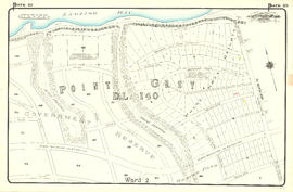
Part of City of Vancouver Archives technical and cartographic drawing collection
Item is a map depicting an area bounded by the following streets: Ontario Street (west side only) to approximate location of modern West 69th Avenue to Fremlin Avenue to the Fraser River.
![Plate 48 [Denman Street to Georgia Street to Chilco Street to Haro Street]](/uploads/r/null/3/1/f/31fb02a8c5fe87fb75e5649e7258d40f099d74790b6b817c055a23c47062f367/8c3c6be0-14fe-4dd0-a122-b7dcf4a5f252-1972-582_142.jpg)
Plate 48 [Denman Street to Georgia Street to Chilco Street to Haro Street]
Part of City of Vancouver Archives technical and cartographic drawing collection
![Plate 47 [Hornby Street to Pender Street to Thurlow Street to Georgia Street]](/uploads/r/null/0/6/8/0682899a1add7d3f6ef14e4aa250437377cc525aeea8cd8d3a1d64f81636b222/413a1cd4-4fee-46b5-b49c-96b3cd30f8ce-1972-582_142.jpg)
Plate 47 [Hornby Street to Pender Street to Thurlow Street to Georgia Street]
Part of City of Vancouver Archives technical and cartographic drawing collection

Part of City of Vancouver Archives technical and cartographic drawing collection
Item is a map depicting an area bounded by the following streets: Shaughnessy Street to Townsend Road [now West 70th Avenue] to east portion of District Lot 317 to the Fraser River.
![Plate 46 [Thurlow Street to Canadian Pacific right-of-way to Bute Street to Georgia Street]](/uploads/r/null/5/9/f/59fddbd648aac61a1c6c56b0121fac2a9f07bd91756ebdf08cd47779553b2c7d/c80bf37d-14f8-4766-8e8c-2542a5ce2b71-1972-582_142.jpg)
Plate 46 [Thurlow Street to Canadian Pacific right-of-way to Bute Street to Georgia Street]
Part of City of Vancouver Archives technical and cartographic drawing collection

Part of City of Vancouver Archives technical and cartographic drawing collection
Item is a map depicting an area bounded by the following streets: Ontario Street to Essex Street/Sixty-first Avenue West to Fremlin Avenue to Townsend Road [now West 70th Avenue].
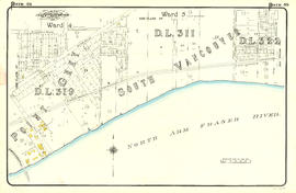
![Plate 45: Eburne [Fremlin Avenue - Buckberry Road - DL 317 - Townsend Road]](/uploads/r/null/5/5/9/5598cfd0ce990ca7fe898ca616c8d59032103fcbbb1ac971f056446b55c6f85c/969c2d6f-977a-423a-a251-279ae90cd87b-MAP342a_142.jpg)
Plate 45: Eburne [Fremlin Avenue - Buckberry Road - DL 317 - Townsend Road]
Part of City of Vancouver Archives technical and cartographic drawing collection
Item is a map depicting an area bounded by the following streets: Fremlin Avenue (west side only) to Buckberry Road [now Park Drive] (south side only) to east portion of District Lot 317 to Townsend Road [now West 70th Avenue] (north side only).
![Plate 45 [Bute Street to Burrard Inlet to Broughton Street to Georgia Street]](/uploads/r/null/6/b/2/6b2bd68ef43ef508e6b5e73ccc11be2e4c6eba69186ef83b384696ef0cf030ed/1debecf1-3785-4682-8575-a9474149bc36-1972-582_142.jpg)
Plate 45 [Bute Street to Burrard Inlet to Broughton Street to Georgia Street]
Part of City of Vancouver Archives technical and cartographic drawing collection

Plate 44: East portion of District Lot 526
Part of City of Vancouver Archives technical and cartographic drawing collection
Item is a map depicting an area bounded by the following streets: Ontario Street to Fifty-first Avenue to Oak Street to approximate location of modern West 61st Avenue..
![Plate 44 [Broughton Street to Burrard Inlet to Cardero Street to Georgia Street]](/uploads/r/null/9/7/f/97fe393ffef9573e51010bcf888bf28e80a2af453e3bc4eea7e18d5da8cbf5ba/e7313e27-ba16-47e7-8484-f929feac471e-1972-582_142.jpg)
Plate 44 [Broughton Street to Burrard Inlet to Cardero Street to Georgia Street]
Part of City of Vancouver Archives technical and cartographic drawing collection
![Plate 43: Point Grey [Oak Street - Fifty-third Avenue - Maple Street - Sixty-first Avenue]](/uploads/r/null/0/1/2/0128f370e81c187f858e4dd8d1c56123f245fac386e61c2814dac4e42c3fb5e1/2d462a46-87dc-44f5-892d-bf76b2a0c867-MAP342a_142.jpg)
Plate 43: Point Grey [Oak Street - Fifty-third Avenue - Maple Street - Sixty-first Avenue]
Part of City of Vancouver Archives technical and cartographic drawing collection
Item is a map depicting an area bounded by the following streets: Oak Street (west side only) to appoximate location of modern West 53rd Avenue to approximate location of modern Maple Street to approximate location of modern West 61st Avenue.
![Plate 43 Cardero Street to Burrard Inlet to Denman Street to Georgia Street]](/uploads/r/null/2/3/a/23abbc83a718d4fe100dd94c7dd0ba4eb96bbf4e316288ebe90a5dc49bbb699b/0b843b5a-9b76-4d60-88dd-3031b79cfa17-1972-582_142.jpg)
Plate 43 Cardero Street to Burrard Inlet to Denman Street to Georgia Street]
Part of City of Vancouver Archives technical and cartographic drawing collection

Part of City of Vancouver Archives technical and cartographic drawing collection
Item is a map depicting an area bounded by the following streets: Ontario Street to appoximate location of modern West 39th Avenue to Oak Street to Forty-ninth Avenue (Point Grey)/Fifty-first Avenue (South Vancouver).
![Plate 42 [Denman Street to Burrard Inlet to Chilco Street to Georgia Street]](/uploads/r/null/2/b/0/2b0746ea5672c134a873ff4b093d2b9354e08e820114151c3174f746ae4765da/75916d07-7c70-452c-8df0-fef3c04b128e-1972-582_142.jpg)
Plate 42 [Denman Street to Burrard Inlet to Chilco Street to Georgia Street]
Part of City of Vancouver Archives technical and cartographic drawing collection
![Plate 41: Point Grey [Oak Street - Forty-third Avenue - Maple Street - Fifty-third Avenue]](/uploads/r/null/5/c/4/5c49ce9e62c8124e60724ba4658ef672c9a8577a72b7470712e755f225e5e53c/40c68f07-c590-4dd6-8980-19dae2c185f8-MAP342a_142.jpg)
Plate 41: Point Grey [Oak Street - Forty-third Avenue - Maple Street - Fifty-third Avenue]
Part of City of Vancouver Archives technical and cartographic drawing collection
Item is a map depicting an area bounded by the following streets: Oak Street to approximate location of current West 43rd Avenue to approximate location of current Maple Street to approximate location of current West 53rd Avenue.

Part of City of Vancouver Archives technical and cartographic drawing collection
Item is a map depicting an area bounded by the following streets: approximate location of current Maple Street to Forty-ninth Avenue (south side only) to Carnarvon Street (east side only) to approximate location of current West 54th Avenue and western edge of District Lot 325A.
![Plate 4: Waterfront Bute Street - Burrard Inlet - Bidwell Street - Georgia Street]](/uploads/r/null/5/6/e/56e493b1b8b9ebd5e77bae9be83741618c7d3b1c1b6a2992e4b6ef5edac7e16b/6eed9ed2-73a1-44f2-9e37-165d726d7fcb-MAP342a_142.jpg)
Plate 4: Waterfront Bute Street - Burrard Inlet - Bidwell Street - Georgia Street]
Part of City of Vancouver Archives technical and cartographic drawing collection
Item is a map depicting an area bounded by the following streets: Bute Street (including 1/2 block adjacent east) to Burrard Inlet to Bidwell Street (east side only) to Georgia Street (north side only).
![Plate 4 [Hamilton & Cambie Streets to CP Railway yards to Seymour Street to Pender Street]](/uploads/r/null/7/e/9/7e931c45a666b558ca27b156ef8b243f5244a2820199fe50e04a7aaed21eeb20/06bd9672-ba7d-4013-aaac-2d7c9d8c5188-1972-582_142.jpg)
Plate 4 [Hamilton & Cambie Streets to CP Railway yards to Seymour Street to Pender Street]
Part of City of Vancouver Archives technical and cartographic drawing collection

Part of City of Vancouver Archives technical and cartographic drawing collection
Item is a map depicting an area bounded by the following streets: Carnarvon Street (west side only) to Fifty-first Avenue (south side only) to Fraser River to Bruce Street [now Wallace Street]/Musqueam Reserve.
![Plate 38: Kerrisdale [Maple Street - Thirty-ninth Avenue - Carnarvon Street - Forty-ninth Street]](/uploads/r/null/8/8/7/8877319961d5b79d8baacd1f17610d932fc144c32cdc4d51c091b6508e5f91ac/5003435f-0706-4579-9683-4be095514a59-MAP342a_142.jpg)
Plate 38: Kerrisdale [Maple Street - Thirty-ninth Avenue - Carnarvon Street - Forty-ninth Street]
Part of City of Vancouver Archives technical and cartographic drawing collection
Item is a map depicting an area bounded by the following streets: Maple Street (west side only) to Thirty-ninth Avenue (south side only) to Carnarvon Street (east side only) to Forty-ninth Avenue (north side only).