
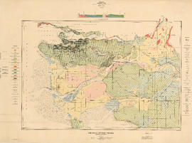
Commercial map of Greater Vancouver and district
![Commercial map of Greater Vancouver and district [assessment districts]](/uploads/r/null/0/9/2/0928add1a06ab55bc236f8bebb87712b7e6ad4422db32cc3065efe7c9da96c04/b5b4129d-f9ba-49b9-a863-2ab6e954897e-MAP102_142.jpg)
Commercial map of Greater Vancouver and district [assessment districts]

Composite aerial mosaic of metropolitan Vancouver

Continuacion de los reconocimientos hechos en la cost No. America

Contour map showing surveyed lots, notes on vegetation and routes traveled on mountaineering expeditions

Coquitlam
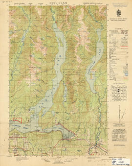
Coquitlam
![C.P.R. [Canadian Pacific Railway] Land Department : Shaughnessy Heights](/uploads/r/null/b/4/5/b45f6c8bb0c605bac487bce451fdb4aab1b7f1f6640b3522a7b08a1f7951b667/2a0cca04-e3e3-48b6-8bb4-30ea1fa948cf-MAP1057_142.jpg)
C.P.R. [Canadian Pacific Railway] Land Department : Shaughnessy Heights
CPR Vancouver Opera House balcony plan
![CPR Vancouver Opera House elevation to Farrell apartment building [south]](/uploads/r/null/a/5/d/a5d0b51f5ebdb12f52ebe4d7b4789fdeba6d42de6c545267e9cc245f6f760007/f58c68f3-d53f-4433-b4a9-9e9510f429c5-1989-20_142.jpg)
CPR Vancouver Opera House elevation to Farrell apartment building [south]
![CPR Vancouver Opera House elevation to hotel [north]](/uploads/r/null/f/d/3/fd36e9463c257d654596ac0175eda976e793e46e728364441848badc37ba1faf/cd3849c0-8d60-4452-a85c-b4457d6509b1-1989-20_142.jpg)
CPR Vancouver Opera House elevation to hotel [north]

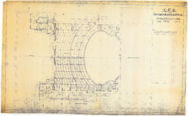
CPR Vancouver Opera House Gallery plan, ceiling plan and section
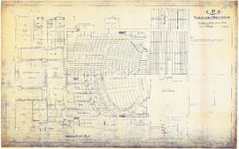
CPR Vancouver Opera House ground floor plan
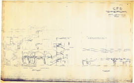
CPR Vancouver Opera House longitudinal section
CPR Vancouver Opera House sections A-A and B-B
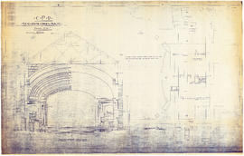
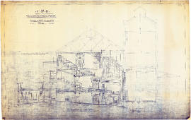
CPR Vancouver Opera House transverse section and basement plan

CPR Vancouver Opera House trusses for gallery and balcony
![[Cross sections of ocean floor between Vancouver Island and mainland of British Columbia]](/uploads/r/null/c/a/6/ca687b43e46696a0c1d9223ef1e80ebe50bba0ea48092c458b525fc90f7b517c/7d458083-64ae-4682-be03-8fd1211e38c9-MAP8b_142.jpg)
[Cross sections of ocean floor between Vancouver Island and mainland of British Columbia]

Development in the western portion of the Lower Mainland region, 1968

Distribution system of waterworks, City of New Westminster, British Columbia
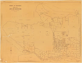
District lot boundaries with the City of Vancouver, British Columbia

District lot boundaries with the City of Vancouver, British Columbia, D.L. map 40
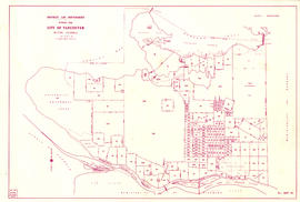
District lot boundaries within the City of Vancouver

District lot boundaries within the City of Vancouver, British Columbia
![D.L. 301 - Ward 8 [location of water pipes and hydrants]](/uploads/r/null/7/b/7b8914ef9132a2e20fa03008daf1a70f3de861b767043aaf338abaeeb42423d7/ce1965c6-6a58-454c-9630-0fcba30688bf-MAP72_142.jpg)
D.L. 301 - Ward 8 [location of water pipes and hydrants]
![D.L. [District Lot] 526](/uploads/r/null/c/b/4/cb45fc2541156cf0f1c89b637733e961198017ddd4aa199ba866f1150856a8ba/dfb19024-a115-4097-9258-559e228c275d-MAP332_142.jpg)
D.L. [District Lot] 526
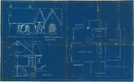
Drawing for unidentified bungalow

Drawing for unidentified bungalow
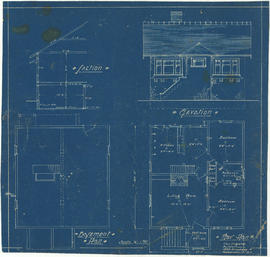
Elevation, section and basement plan

False Creek Basin

False Creek interim harbour headline

False Creek, Vancouver, B.C.
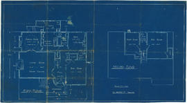
First and second floor plans

First floor plan

First Narrows. Proposed Suspension Bridge for Foot Passengers Only

First Narrows, Burrard Inlet, B.C. showing Parthia and Burnaby shoals
![[First section of] Shaughnessy Heights](/uploads/r/null/c/d/0/cd05f96b7e9f01fee4ba2afe83ac83cef9d70b3cf83d3ba8c4ebe5a0a20a429d/0d2ec941-063b-4722-8d84-aff283b273f6-MAP329_142.jpg)
[First section of] Shaughnessy Heights

Floor plans for unidentified house

Fragment de la carte reduite d'une partie de l'Amerique septentroniale pe le Cap. John Meares 1791

Fraser River - Annacis Island sheet

Fraser River - Deas Island sheet

Fraser River - Ladner sheet

Fraser River - New Westminster sheet

Fraser River - Port Mann sheet

Fraser River - Sand heads sheet

Fraser River - Steveston sheet

Fraser River - Tilbury Island sheet

Fraser River - triangulation control
Fraser River Delta, British Columbia

Fraser River Delta, British Columbia