Title and statement of responsibility area
Title proper
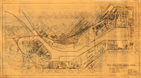
False Creek interim harbour headline
General material designation
- Cartographic material
Parallel title
Other title information
Title statements of responsibility
drawn by F. Wile.
Title notes
Level of description
Item
Reference code
AM1594-: MAP 756
Edition area
Edition statement
Edition statement of responsibility
Class of material specific details area
Statement of scale (cartographic)
1:2 400
Statement of projection (cartographic)
Statement of coordinates (cartographic)
Statement of scale (architectural)
Issuing jurisdiction and denomination (philatelic)
Dates of creation area
Date(s)
-
1962 (Publication)
- Publisher
- Vancouver (B.C.). Planning Department. Transportation Planning Section
- Place
- Vancouver (B.C.)
Physical description area
Physical description
1 map : white print ; 85.5 x 155 cm
Publisher's series area
Title proper of publisher's series
Parallel titles of publisher's series
Other title information of publisher's series
Statement of responsibility relating to publisher's series
Numbering within publisher's series
Note on publisher's series
Archival description area
Custodial history
Scope and content
Map shows interim and ultimate headline, interim headline, ultimate headline, and existing headline, as well as streets, lots, railway yards and waterfront industries in the False Creek area. Map was created for the "False Creek development" study, "Harbour headline" project.
Notes area
Physical condition
Map is torn in the upper right corner.
Immediate source of acquisition
Arrangement
Language of material
Script of material
Location of originals
Availability of other formats
Use microfiche copy in Reading Room.
Restrictions on access
Terms governing use, reproduction, and publication
Finding aids
Associated materials
See also MAP 964.
Accruals
General note
Map formerly located at 205-C
Alpha-numeric designations
Drawing number 3765, base map 1099-G. File number F.10.4.1
External Link
ftp://webftp.vancouver.ca/archives/MAPS-TIFF/MAP756.tif
Format: TIFF (LZW compressed)
MD5: BABC2A814F953B94631A9D6A810FA555
*Size: 197974688 bytes

