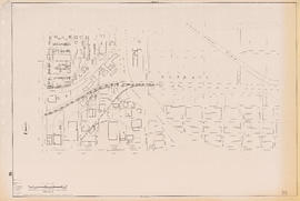
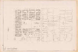
Sectional map of Vancouver showing streets, block and lot outlines, and building perimeters : Map 36 : Rupert Street to Boundary Road and Grandview Highway to 22nd Avenue
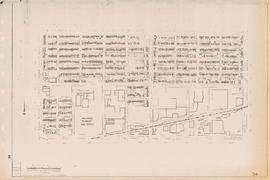
Sectional map of Vancouver showing streets, block and lot outlines, and building perimeters : Map 35 : Rupert Street to Boundary Road and 5th Avenue to Grandview Highway
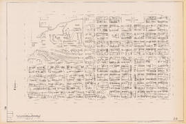
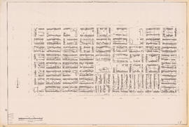
Sectional map of Vancouver showing streets, block and lot outlines, and building perimeters : Map 34 : Nanaimo Street to Rupert Street and 5th Avenue to Grandview Highway North
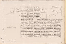
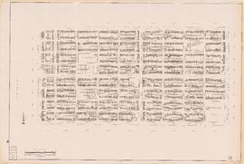
Sectional map of Vancouver showing streets, block and lot outlines, and building perimeters : Map 33 : Clark Drive to Nanaimo Street and 2nd Avenue to 13th Avenue
Sectional map of Vancouver showing streets, block and lot outlines, and building perimeters : Map 31 : Oak Street to Main Street and 6th Avenue/4th Avenue to 16th Avenue
Sectional map of Vancouver showing streets, block and lot outlines, and building perimeters : Map 30 : Maple Street to Oak Street and 3rd Avenue/6th Avenue to 14th Avenue
Sectional map of Vancouver showing streets, block and lot outlines, and building perimeters : Map 29 : Balaclava Street to Maple Street and 3rd Avenue to 14th Avenue
Sectional map of Vancouver showing streets, block and lot outlines, and building perimeters : Map 28 : Camosun Street to Balaclava Street and 4th Avenue to 14th Avenue
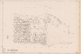
Sectional map of Vancouver showing streets, block and lot outlines, and building perimeters : Map 27 : Blanca Street to Camosun Street and 4th Avenue to 14th Avenue
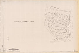
Sectional map of Vancouver showing streets, block and lot outlines, and building perimeters : Map 26 : University Endowment Lands to Blanca Street and N.W. Marine Drive to 4th Avenue
Sectional map of Vancouver showing streets, block and lot outlines, and building perimeters : Map 25 : Blanca Street to Jericho Beach Park and English Bay to 4th Avenue
Sectional map of Vancouver showing streets, block and lot outlines, and building perimeters : Map 24 : Jericho Beach Park to Balaclava Street and English Bay to 4th Avenue
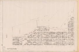
Sectional map of Vancouver showing streets, block and lot outlines, and building perimeters : Map 23 : Balaclava Street to Maple Street and English Bay to 3rd Avenue
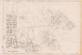
Sectional map of Vancouver showing streets, block and lot outlines, and building perimeters : Map 22 : Maple Street to Drake Street and Vanier Park/Sunset Beach to 4th Avenue
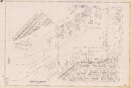
Sectional map of Vancouver showing streets, block and lot outlines, and building perimeters : Map 21 : False Creek waterfront and adjacent buildings from foot of Drake Street to Main Street
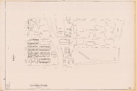
Sectional map of Vancouver showing streets, block and lot outlines, and building perimeters : Map 20 : Main Street to Clark Drive and Prior Street to 2nd Avenue/Great Northern Way
Sectional map of Vancouver showing streets, block and lot outlines, and building perimeters : Map 19 : Clark Drive to Nanaimo Street and Frances Street/Ferndale Street to 2nd Avenue
Sectional map of Vancouver showing streets, block and lot outlines, and building perimeters : Map 18 : Nanaimo Street to Rupert Street and Charles Street to 5th Avenue
Sectional map of Vancouver showing streets, block and lot outlines, and building perimeters : Map 17 : Nanaimo Street to Rupert Street and Pender Street to Charles Street
Sectional map of Vancouver showing streets, block and lot outlines, and building perimeters : Map 16 : Rupert Street to Boundary Road and Kitchener Street to 5th Avenue
Sectional map of Vancouver showing streets, block and lot outlines, and building perimeters : Map 15 : Rupert Street to Boundary Road and Pender Street to Kitchener Street
Sectional map of Vancouver showing streets, block and lot outlines, and building perimeters : Map 14 : Cassiar Street to Boundary Road and Eton Street to Pender Street
Sectional map of Vancouver showing streets, block and lot outlines, and building perimeters : Map 13 : Rupert Street to Boundary Road and Burrard Inlet to Eton Street
Sectional map of Vancouver showing streets, block and lot outlines, and building perimeters : Map 12 : Nanaimo Street to Cassiar Street and McGill Street/Wall Street to Pender Street
Sectional map of Vancouver showing streets, block and lot outlines, and building perimeters : Map 11 : Nanaimo Street to Rupert Street and Burrard Inlet to McGill Street
Sectional map of Vancouver showing streets, block and lot outlines, and building perimeters : Map 10 : Clark Drive to Nanaimo Street and Burrard Inlet to Frances Street/Ferndale Street
Proposed elevated waterfront roadway
Proposed development of waterfront. South shore Burrard Inlet
Preventing tooth decay : infants and toddlers
Preventing tooth decay : infants and toddlers
Preventing tooth decay : infants and toddlers
Preventing tooth decay : infants and toddlers
Preventing tooth decay : infants and toddlers
Present use. Vancouver harbour
Preliminary report on civic centre
Port of Vancouver water-borne imports
Port of Vancouver water-borne exports
Peer pressure: giving independence with responsibility and gender differences
One way streets : illustrations of special intersections
One way streets : Illustrated map of Downtown Vancouver
Official Regional Plan : proposed amendments within the City of Vancouver
North-East Burnaby Study, revised Simon Fraser townsite plan : 1967 City of Vancouver alternative proposals
Map of City of Vancouver showing schools, parks, community centres, libraries, health units
Listen to the children
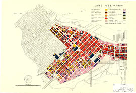
Land use - 1954
Historical park development
Healthy eating for school age children
Healthy eating for school age children
Healthy eating for school age children
Greater Vancouver British Columbia Railroads and Harbour