
- PUB-: PD 2596b-: LEG1355.07
- Part
- 2000
Part of City publications collection
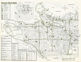
Part contains a map of Vancouver bicycle routes with a key to attractions, bridges and ferries, and downtown bicycle parking locations. An inset map shows Downtown Vancouver in more detail.


![[Sheet 9 : Main Street to Clark Drive and Prior Street to Burrard Inlet]](/uploads/r/null/c/a/ca4b4713bea0118fec812e6258afe5c1efa039db74073214703001a47b00f122/5e0d243a-99ae-42aa-8bb3-4a1abe9e1209-MAP339_142.jpg)
![[Sheet 89 : North Arm of Fraser River to Southwest Marine Drive and Barnard Street]](/uploads/r/null/f/9/f98aff3ec8879da9a55c5b6dbe11a8bbc03439210831ff3b0cc884e0ac4bbcfd/ba8da922-1aaa-419f-93de-9658629a43b7-MAP339_142.jpg)
![[Sheet 88 : Macdonald Street to Angus Drive and Edgington Avenue to Fifty-seventh Avenue]](/uploads/r/null/5/9/595b991e091f624b5f74507db063dddb150624fbef03fe1d577f8d7a32bb9088/8afa1350-f31b-43bd-a14f-0ea9082c21fe-MAP339_142.jpg)
![[Sheet 87 : Barnard Street to Heather Street and Beckwith Road to Seventy-fifth Avenue]](/uploads/r/null/5/b/5b41d7f129096861b243317317db68bc0b54890dd82076ae972b78c504318686/01e0f65c-cd9d-4050-8861-1cafa29a58cc-MAP339_142.jpg)
![[Sheet 86 : Angus Drive to Laurel Street and Seventy-fifth Avenue to Sixty-seventh Avenue]](/uploads/r/null/6/e/6efd95dacdad7f8976575767597855d90ccaa34e423b1ba76885d33d2dffb725/8167b0a2-0792-4e60-9755-7a4706830df0-MAP339_142.jpg)
![[Sheet 85 : Laburnum Street to Fremlin Street and Sixty-eighth Avenue to Fifty-seventh Avenue]](/uploads/r/null/a/b/ab9f29b0e940cdcc4947062af96fb062d03e6ee1a34cac14d94b05edec4e2463/b9e1d243-5b38-4c67-ad11-2beba81bb35b-MAP339_142.jpg)
![[Sheet 83 : Fremlin Street to Main Street and Southwest Marine Drive to Fifty-seventh Avenue]](/uploads/r/null/3/e/3efc869894db6ec7c88cf96b10cd2cb7f93db04cae7e1f6f35be1ac51c2bdc14/6323fdeb-3ce2-4794-bc7f-691ce81ee431-MAP339_142.jpg)

![[Sheet 81 : Main Street to Inverness Street and Southeast Marine Drive to Fifty-seventh Avenue]](/uploads/r/null/9/5/9518e71d1e1780cdb281e3519ba78f0606992747daac9a2701b7f7ff38a67a92/65136071-c971-4835-877a-159bf293b14d-MAP339_142.jpg)

![[Sheet 8 : Main Street to Clark Drive and Alexander Street to Burrard Inlet]](/uploads/r/null/a/1/a10fe461f7836acc659d886d1888eef9d17bfc99d33e474c29ae025ed531b50c/e81d36a6-a6c1-40a5-852b-ef52bfbdb8dd-MAP339_142.jpg)
![[Sheet 79 : Gladstone Street to Kerr Street and North Arm of Fraser River to Bobolink Avenue]](/uploads/r/null/7/9/79214408afd85e4ab6ccc7eec43ecc85caf5ce5dedb9cfeb219866aa0091a733/7696de5a-3bba-4c2d-bc6c-83bf14bcf845-MAP339_142.jpg)
![[Sheet 78 : Kerr Street to Ivy Avenue and North Arm of Fraser River to Southeast Marine Drive]](/uploads/r/null/9/0/90c6186a1aa17588ec162078d412440a826f55dc10a9d49f8e74df97a4d3ff6e/0a3e4f49-3d6d-4dec-95f1-08aa42e666d8-MAP339_142.jpg)
![[Sheet 75 : Nanaimo Street to Kerr Street and Bobolink Avenue to Forty-ninth Avenue]](/uploads/r/null/d/1/d14981939464fabe5e1b9488ecd26d62b3e16b1f4d1b8e00ece1bac6fa0dbdfa/a8e1d890-9726-473c-8f49-69d918d62d56-MAP339_142.jpg)
![[Sheet 72 : Oak Street to Quebec Street and Fifty-eighth Avenue to Forty-sixth Avenue]](/uploads/r/null/d/9/d95b8e85252fc5bb5a704534795819328aaac0251d8659e64190e79cd61b3037/43d93b13-ddc2-4f78-9ba2-07fbbcf3baa9-MAP339_142.jpg)
![[Sheet 71 : Cypress Street to Oak Street and Fifty-seventh Avenue to Forty-ninth Avenue]](/uploads/r/null/2/e/2e8486f7c4713b8b62d288d2b813433a3a829f9e8a649c4bcf57b64c1e37f64a/84f27baf-7943-4b5e-8361-8b72443ed274-MAP339_142.jpg)
![[Sheet 70 : Macdonald Street to Cypress Street and Fifty-seventh Avenue to Forty-ninth Avenue]](/uploads/r/null/f/9/f92d773f16070e3762b2b8519c7993087e55cec394d3c593367dd2f160a3e9ad/b01f6a8d-18a1-4872-b084-475fd79e81da-MAP339_142.jpg)
![[Sheet 7 : Burrard Street to Main Street and Georgia Viaduct to Burrard Inlet]](/uploads/r/null/c/d/cd235086cbaf81487b8784fb32b6ef913f4fe27305678cd1961adf506324c250/8f72f6bd-1013-48ad-a56c-e6269cb6f5a8-MAP339_142.jpg)


![[Sheet 65 : Camosun Street to Carnarvon Street and Forty-first Avenue to Thirty-third Avenue]](/uploads/r/null/4/0/407c98f21cf3d2ce519b79e8a505fd6a325c965dc1550cdbc00d96b7bc7e5e3d/04862e6e-5125-4593-84de-c80135fd76ce-MAP339_142.jpg)
![[Sheet 64 : Balaclava Street to Cypress Street and Forty-ninth Avenue to Forty-first Avenue]](/uploads/r/null/6/d/6d41bb5db0383d13fdc92e51638fb1e2c9ac8e11a664fd9070ee16be3212d8f5/07989ba9-42ff-4d9a-ac56-a25405a93120-MAP339_142.jpg)
![[Sheet 63 : Carnarvon Street to Cypress Street and Forty-first Avenue to Thirty-third Avenue]](/uploads/r/null/4/3/43f21afad72cf7d769c23be0a8b778e288335df1801a3b9d42bace4e74c8ea1a/64b6fa50-ede8-4087-81fc-6b7da9b7dfd1-MAP339_142.jpg)
![[Sheet 62 : Cypress Street to Oak Street and Forty-ninth Avenue to Forty-first Avenue]](/uploads/r/null/7/c/7c5b951f94dee2cfd6a1b82979539f15bd77424ef36377f8e2db0e7bfb4aae10/78c561eb-987a-4aef-9574-18f261df2111-MAP339_142.jpg)
![[Sheet 61 : Cypress Street to Oak Street and Forty-first Avenue to Thirty-third Avenue]](/uploads/r/null/e/c/ecb192d35087c4f7d7713e1578ae0bc7f934c92ab822401e070cf7a4cf61fdf3/1cfa7241-9da6-4626-aedb-d6bfa44f7d5e-MAP339_142.jpg)
![[Sheet 60 : Oak Street to Quebec Street and Forty-sixth Avenue to Thirty-seventh Avenue]](/uploads/r/null/b/5/b5e1b3fe1dda55eb9d0029fcbe47cb6048a48720c1ad1f7b1897640d35203319/e097b4d6-7a5c-41bc-9ca5-1b9e7b57eccc-MAP339_142.jpg)
![[Sheet 6 : Nicola Street to Beatty Street and English Bay Beach to Georgia Street]](/uploads/r/null/f/2/f2effc97084427c0bd73bae3566d3ad910caaa6e7fb3e5ed9f3ece81bd2ac0a1/f2cc48a6-1195-4dd8-8227-71d36d1791bb-MAP339_142.jpg)
![[Sheet 59 : Quebec Street to Inverness Street and Forty-seventh Avenue to Thirty-seventh Avenue]](/uploads/r/null/0/1/015bc0f349dc1228105d4cdd774354b22820bad860e0a822b707d62c3eb343f5/b9fe9076-66e5-4167-b081-e65e8b625778-MAP339_142.jpg)
![[Sheet 58 : Inverness Street to Nanaimo Street and Forty-ninth Avenue to Forty-first Avenue]](/uploads/r/null/5/5/55825f5529a2ab4a1b9c04e6d086f342c86830cc9828262a5f7b22eab255b346/4ce8baf7-a89b-4c24-bec2-d1a45477ca67-MAP339_142.jpg)

![[Sheet 56 : Doman Street and Joyce Street to Boundary Road and Forty-ninth Avenue to Kingsway]](/uploads/r/null/5/e/5ee0f6b78ce9f3b0e0e39795d6220cd37d587872bad7b41b67f4d29c7cb49d4c/f8a321d6-ea4f-4e1f-85da-6d12e149ea85-MAP339_142.jpg)


![[Sheet 53 : Inverness Street to Nanaimo Street and Forty-first Avenue to Thirty-second Avenue]](/uploads/r/null/a/9/a9fdfc1181cd3a36ad078c24a5892d8bfc60c5456733839fa59914d5700e6509/5f8f4fc4-26e4-49f3-b5d4-acced16d8490-MAP339_142.jpg)
![[Sheet 52 : Inverness Street to Nanaimo Street and Thirty-second Avenue to Twenty-second Avenue]](/uploads/r/null/8/0/80540d4a84d80b164711e9d69d163532d3d064da5a77cf784a15f7025db7ce7a/29b188a1-6a45-4c89-b95b-7238c42064f0-MAP339_142.jpg)
![[Sheet 51 : Ontario Street to Inverness Street and Thirty-seventh Avenue to Twenty-eighth Avenue]](/uploads/r/null/3/a/3aee300fe6dd39cf02ce71f3cbf8199220cf19dc59148fcf8db71a0bdc7f8239/c1783bd2-c47b-43ed-a71d-29571b121241-MAP339_142.jpg)
![[Sheet 50 : Oak Street to Ontario Street and Thirty-seventh Avenue to Twenty-eighth Avenue]](/uploads/r/null/a/3/a3b7d0414ced2d15d401c5747a576809010cc56bb00c564251adecdb35091358/01957154-6807-4889-bc0f-a1f2455ab066-MAP339_142.jpg)
![[Sheet 5 : Stanley Park to Nicola Street and English Bay Beach to Robson Street]](/uploads/r/null/1/d/1daf1ff2196704e4e82a6b5c7476ee3e8a46b4e0740f3c37f3f58813f5f8b5f0/ee3a2706-4ebe-4ee8-b4db-da89840c7f89-MAP339_142.jpg)
![[Sheet 47 : Camosun Street to Blenheim Street and Thirty-third Avenue to King Edward Avenue]](/uploads/r/null/5/9/59c6b01a85dc6051f7cfecf1f33eb7e7017beb24d0dd57b512fcddc2063e3e8f/eabe5a9f-362b-46a4-9efc-275f9b96459b-MAP339_142.jpg)
![[Sheet 46 : Blanca Street to Discovery Street and Sixteenth Avenue to Fourteenth Avenue]](/uploads/r/null/9/0/90f542cbf378be4c0b5366f96f6c5575e76ea3a215a1d517a5c1b7c12ca2425c/8324fff9-cff3-4306-89c6-e6157d1e36a0-MAP339_142.jpg)
![[Sheet 45 : Discovery Street to Blenheim Street and King Edward Avenue to Fourteenth Avenue]](/uploads/r/null/7/b/7b9edfc2a053f0ba6c95af404ad3bf4f22a5e63ff6ddcd9acea2fd6dc469d916/ef5279fc-e406-412e-9886-eddb46d44c27-MAP339_142.jpg)
![[Sheet 44 : Blenheim Street to Arbutus Street and King Edward Avenue to Fourteenth Avenue]](/uploads/r/null/2/f/2fdf5060ec6fdc47756dc75416312dd42047abea2beed2d99f086c73bd0c8726/2fe0f45d-ad6c-46e6-9a9f-50c795523f5f-MAP339_142.jpg)
![[Sheet 43 : East Boulevard to Oak Street and Laurier Avenue to Fourteenth Avenue]](/uploads/r/null/8/8/8846e3e6c19438103b656786c264d5dcccc37b59de3cf8fa85bb05f01b65d8f9/9fb3d6cb-93e9-48d0-be52-05cc55ad4ec4-MAP339_142.jpg)
![[Sheet 42 : Oak Street to Ontario Street and Twenty-eighth Avenue to Sixteenth Avenue]](/uploads/r/null/c/7/c7489c984c3ec99abcbb22a87a294856654f9c25046416db253386367e8f4001/9f397dcd-244e-47bf-8acc-e4ae1dcd8a0d-MAP339_142.jpg)
![[Sheet 41 : Ontario Street to Inverness Street and Twenty-eighth Avenue to Sixteenth Avenue]](/uploads/r/null/c/2/c22ca2538905633f64373261ce970df6216075ce4de9e22d491c2e212ce17c1f/616ab944-e39a-4c66-abb4-918b17cc3252-MAP339_142.jpg)