
Vest pocket map of Vancouver : map cover
- AM1594-: MAP 59-: LEG1277.5
- Part
- 1905
Part of City of Vancouver Archives technical and cartographic drawing collection
1440 results with digital objects Show results with digital objects
Vest pocket map of Vancouver : map cover
Part of City of Vancouver Archives technical and cartographic drawing collection

Vest pocket map of Vancouver : map D
Part of City of Vancouver Archives technical and cartographic drawing collection
Part shows Vancouver from Heather Street to Garden Drive and Grant Street to Sixteenth Avenue. Shows district lot and block numbers, public schools, and hospitals.
Victoria and Vancouver street and vicinity maps
Part of City of Vancouver Archives technical and cartographic drawing collection
Item is a map sheet with street and other maps of Greater Vancouver, Greater Victoria, and highways maps of the surrounding areas.

Victoria, vicinity and Vancouver Island
Part of City of Vancouver Archives technical and cartographic drawing collection
Part is a sheet with three maps: a street map of Victoria, a map of major roads and highways in Greater Victoria, and a highway map of Vancouver Island. The sheet includes street indexes and a mileage chart.
Views of Chilliwack valley and town
Part of City of Vancouver Archives technical and cartographic drawing collection
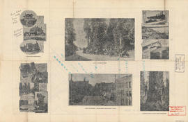
Part of City of Vancouver Archives technical and cartographic drawing collection
Part contains promotional images of Vancouver including residences, Stanley Park, English Bay, and Hastings Street.
Visit the Scenery Shop, souvenir headquarters
Part of City of Vancouver Archives technical and cartographic drawing collection
Item is a promotional brochure for The Scenery Shop, a retailer of souvenirs located at 656 Granville Street. One side of the brochure when unfolded displays a map designed by the shop's proprietor, William L. Webber, showing points of interest and an inset map showing the location of the shop. The other side of the unfolded sheet shows photographs and lists of products available in the shop.

Part of City of Vancouver Archives technical and cartographic drawing collection
Part is one side of a brochure for the Scenery Shop, displaying images , descriptions and prices of various souvenirs available.

Part of City of Vancouver Archives technical and cartographic drawing collection
Part is the front sheet of an unfolded tourism brochure showing Vancouver tourist attractions, The sheet includes a map of downtown Vancouver, with transportation information, a map of the roads in Stanley Park, photographs and information on various sites and attractions in the city, as well as general promotional information.
Part of City of Vancouver Archives technical and cartographic drawing collection
Item is a map and tourist guide to Vancouver showing major roadways and tourist attractions in the Greater Vancouver area on one side, and Stanley Park, downtown Vancouver, and textual tourist information on the other.
Part of City of Vancouver Archives technical and cartographic drawing collection
Item is a tourist brochure, including maps showing attractions, photographs and graphics depicting various attractions and tourist information. The larger map on the reverse side of the unfolded brochure shows the location of attractions in Greater Vancouver.

Part of City of Vancouver Archives technical and cartographic drawing collection
Part is the reverse side of a tourism brochure, containing a tourist map of Greater Vancouver, showing major roads, locations of tourist attractions and recreational sites, and routes into Vancouver.

Part of City of Vancouver Archives technical and cartographic drawing collection
Part contains an illustrated map of Greater Vancouver showing major streets and tourist attractions.

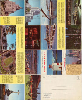
Visitors map of Vancouver ; world famous Stanley Park ; downtown Vancouver
Part of City of Vancouver Archives technical and cartographic drawing collection
Part contains detail maps of Stanley Park and downtown Vancouver, tourist information including traffic rules, locations of churches, golf courses, and amenities, and a list of member businesses of the Vancouver Tourist Association.
Visitors map. Southwestern British Columbia & Greater Vancouver, Canada
Part of City of Vancouver Archives technical and cartographic drawing collection
Item is a tourist brochure which includes maps, illustrations and text providing information on tourist sites and municipalities in the Greater Vancouver Regional District.
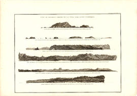
Vue de diverses parties de la côte nord-ouest d'Amérique
Part of City of Vancouver Archives technical and cartographic drawing collection
Item is a graphical plate from an atlas, showing views of Cape Scott, Scott Island, the entrance to Nootka Sound, Woody Point, the entrance to the Columbia River, and Point Barro de Arena. The item is a plate from a French reprinting of "A Voyage of Discovery to the North Pacific Ocean and round the world..." by George Vancouver.
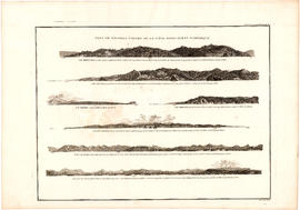
Vue de diverses parties de la côte nord-ouest d'Amérique
Part of City of Vancouver Archives technical and cartographic drawing collection
Item is a graphical plate from an atlas, showing views of Cape Mendocino, Cape Orford, Grenville Point, the entrance to the Straits of Juan de Fuca and the coastline south of Cape Flattery. The item is a plate from a French reprinting of "A Voyage of Discovery to the North Pacific Ocean and round the world..." by George Vancouver.
V.W.W. [Vancouver Water Works] plan shewing tunnel and tramway at Big Canon [Canyon]
Part of City of Vancouver Archives technical and cartographic drawing collection
Item is a sheet showing a topographical map and grade profile of a water supply tunnel running through the Canyon Tunnel at elevation 365' adjacent to the Capilano River, and grades of the route above, through and below the tunnel.
Vancouver (B.C.). Water Works Department

Warehouse and store sites : very centrally located
Part of City of Vancouver Archives technical and cartographic drawing collection
Item is a flyer advertising the sale of a number of lots in the block bounded by Gore Avenue, the Canadian Pacific Railway right-of-way, and Alexander Street. The flyer includes a list of the lots for sale and asking price, as well as a map of the site.
Waterworks map of City of Vancouver
Part of City of Vancouver Archives technical and cartographic drawing collection
Item is a map showing types and quality of water provision services and fire fighting capabilities in various parts of Vancouver: high, low, and intermediate pressure service areas, water main routes and their corresponding sizes, fire limit areas, water flow testing sites, and fire halls.
West section Richmond municipality
Part of City of Vancouver Archives technical and cartographic drawing collection
Item is a copy of part of a published map of Richmond, B.C. The map shows lot numbers, post offices, dikes, streets, roads, swinging bridges, churches, schools, municipal boundaries and geographical features in the area from Marpole in the north to Gunn Island in the south and from Jacombs Road in the east to Sturgeon Bank in the west. The portion has been annotated with a grid, but information is included which indicates what the lines mean.
Part of City of Vancouver Archives technical and cartographic drawing collection
Item is a map showing land subdivisions for West Vancouver, streets, and railway routes.
Part of City of Vancouver Archives technical and cartographic drawing collection
Item is a two-sided road map containing a map of Saskatchewan, Manitoba and the adjoining U.S. states; a map showing Canada and the United States from Labrador and Prince Rupert, B.C. in the north to Richmond, Virginia and San Francisco, California in the south; a map of British Columbia and Alberta; and an illustrated map of Greater Vancouver. The item includes road indexes, a mileage chart for Western Canada, and information on national parks in Western Canada.

What the man who comes to Vancouver wants to know
Part of City of Vancouver Archives technical and cartographic drawing collection
Part contains information on lodging, restaurants, transit, social clubs, and other points of interest in Vancouver.
Where to go, what to do, how to see Vancouver
Part of City of Vancouver Archives technical and cartographic drawing collection
Part consists of photographs of prominent tourist sites in Vancouver, with accompanying descriptive text.
Willard Kitchen residence drawings : Lot 3 Blk 12 D.L. 317/16 (2050 SW Marine Drive)
Part of City of Vancouver Archives technical and cartographic drawing collection
File consists of photocopied floor plans, elevations and cross section drawings, and plumbing specifications for the Willard Kitchen house at 2050 S. W. Marine Drive.
Benzie & Bow
With compliments and greetings of the management and staff of the Yale Hotel and Yale Gardens
Part of City of Vancouver Archives technical and cartographic drawing collection
Part is the outer side of the cover, in which the map was attached map was folded.
World maps and heads of government
Part of City of Vancouver Archives technical and cartographic drawing collection
Item is a sheet with a map of the world and a political and physical map of the Panama Canal Zone; these are surrounded by photographic portraits of twenty-fours heads of state, Roald Amundsen and Robert E. Peary.

Wrigley's 1930 map of Vancouver and Lower Mainland
Part of City of Vancouver Archives technical and cartographic drawing collection
Part contains a map of Greater Vancouver showing streets, paved streets, trails, street car lines, bus lines, railways, auto camps, hospitals, schools and block numbers. Concentric circles spaced one mile apart emanate from a point in downtown Vancouver.
Wrigley's 1930 map of Vancouver and Lower Mainland
Part of City of Vancouver Archives technical and cartographic drawing collection
Item is a map of Greater Vancouver with a street index on verso. Map shows streets, paved streets, trails, street car lines, bus lines, railways, auto camps, hospitals, schools and block numbers. Concentric circles spaced one mile apart emanate from a point in downtown Vancouver.

Wrigley's new map of Vancouver and Lower Mainland
Part of City of Vancouver Archives technical and cartographic drawing collection
Part contains a map showing streets and block numbers in Vancouver, West Vancouver, North Vancouver, Burnaby, New Westminster and the northern part of Richmond.
Wrigley's new revised map of Vancouver
Part of City of Vancouver Archives technical and cartographic drawing collection
Wrigley's new revised official map of Greater Vancouver
Part of City of Vancouver Archives technical and cartographic drawing collection
Item is a street map designed to be kept folded; the item includes panels with advertising for Vancouver shops and other businesses and a street index.

Wrigley's offical arrow city map : Greater Vancouver and New Westminster : map cover
Part of City of Vancouver Archives technical and cartographic drawing collection
Yale Hotel and Yale Gardens [tourist map of Vancouver]
Part of City of Vancouver Archives technical and cartographic drawing collection
Item is a tourist brochure of Vancouver made up of a dial map with a street index. The map was designed to be folded and enclosed in the attached cover.