
Soo River profile from Green River junction west 6 miles 3820 ft
- COV-S346-F01-: MAP 1121g
- Item
- June 8, 1923
Part of City of Vancouver fonds
Soo River profile from Green River junction west 6 miles 3820 ft
Part of City of Vancouver fonds

Soo River profile from 9+2380 to 15+1650
Part of City of Vancouver fonds
Soo River profile from 6+3820 to 9+2380
Part of City of Vancouver fonds

Profiles of sections of Green & Soo Rivers
Part of City of Vancouver fonds

Profile on possible dam sites across Soo River at 2+4340
Part of City of Vancouver fonds

Profile dam no. 2 Soo River at 4+4980
Part of City of Vancouver fonds

Profile 6 Mile Creek from 2+4240 to 3+1990
Part of City of Vancouver fonds

Part of City of Vancouver fonds
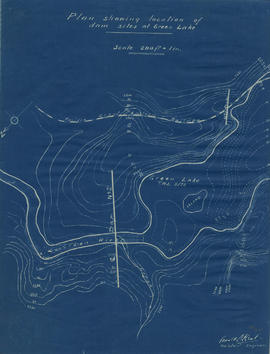
Plan showing locations of dam sites at Green Lake
Part of City of Vancouver fonds
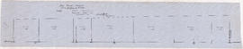
![Longitudinal section along [centre line] of dam sites at north end of Green Lake](/uploads/r/null/7/4/a/74af74789da62d7da66c012dd18dd964e4e83151ac5f0b139a53843bce6ccfe6/974ff05f-0f29-4e65-b818-c663b1a236e1-MAP1142_142.jpg)
Longitudinal section along [centre line] of dam sites at north end of Green Lake
Part of City of Vancouver fonds
Item is a sheet depicting 2 profiles: one of dam no. 1 at railway crossing at 2247+763 and one of dam no. 2 at the head of the Green River (Green Lake).

Part of City of Vancouver fonds
Item is a map sheet containing two profiles: one showing the increased reservoir height with a subsidiary dam built and the other a profile of the proposed subsidiary dam site.