- AM54-S13-: MAP 1025
- Item
- [after 1907]
Part of Major Matthews collection
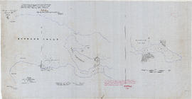
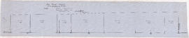
Item consists of a tracing of two maps on one sheet, of a map most likely originally drawn in 1859 or 1860. Based on the copied annotations, this tracing appears to be at least a second (or possibly third) generation tracing from the original map created as a result of the H.M.S. Plumper surveys of the area at that time.
One map shows Burrard Inlet, Point Grey, Spanish Bank [sic], Point Atkinson, English Bay, Downtown Peninsula, Coal Peninsula, Brockton Point, First Narrows and False Creek, and proposed government land reserves in these areas. The second map shows Burrard Inlet and Port Moody and proposed government land reserves in this area.


![Sheet 9D [Slocan Street to Grandview Highway to Marshall Street to 22nd Avenue]](/uploads/r/null/b/1/c/b1c4c0bbf98c9c2ff5a2e60e8350582f0e591688b2f9670ba1f4aaecc638b227/7e2aefcc-f31d-4c11-a0ae-1293bd850528-LEG1153_142.jpg)
![Sheet 9C [Hull Street/Semlin Drive to 14th Avenue to Clark Drive to 22nd Avenue]](/uploads/r/null/b/4/8/b48f272549a65e8622204f5c1a677afad16a9ef19306e9696b31ef6d9c08cf16/c56229a4-c4b1-492d-b215-b5b53f060d69-LEG1153_142.jpg)
![Sheet 9B [Slocan Street to 6th Avenue to Semlin Drive to 14th Avenue]](/uploads/r/null/b/7/5/b75c61b603e8ab998f68941a380457aeae4de4affd845d40405472b07f3738a2/140ef05a-e687-4959-a97a-2765c7610a3c-LEG1153_142.jpg)
![Sheet 9A [Semlin Drive to 6th Avenue to Clark Drive to 14th Avenue]](/uploads/r/null/4/b/8/4b83338cc19b64deb790aac94219d77731e8a711697a611a458656793c63ccda/f3604bbf-e839-474f-a033-6569d2f2d2e0-LEG1153_142.jpg)
![Sheet 8D [Slocan Street to Charles Street to Semlin Drive to 6th Avenue]](/uploads/r/null/9/f/b/9fb954e03525c1c5f3722cf6d1f3b0e0d9ae28c2a0ed307fa25ca0dc6ac46434/416c089e-39ae-49d3-a4fc-472175911de5-LEG1153_142.jpg)
![Sheet 8C [Semlin Drive to Charles Street to Clark Drive to 6th Avenue]](/uploads/r/null/d/e/5/de5abd94c03b4822da51cf8852f7964a5c39823d701d98d5ba364c57d8b08feb/9a85980c-5f83-4684-b501-ff546226a417-LEG1153_142.jpg)
![Sheet 8B [Slocan Street to Pender Street to Semlin Drive to Charles Street]](/uploads/r/null/3/5/4/354478b1921f42f9f80b25d890823ee2c6ef900b23fe032c8504bdf3e7ae0a68/4d6f04e3-89d1-4093-8da7-9692b235a110-LEG1153_142.jpg)
![Sheet 8A [Semlin Drive to Hastings Street to Clark Drive to Charles Street]](/uploads/r/null/c/e/1/ce14d71e20eb294141c9dd954f1318d51d5f7a7cd55238a25a046162a7080d15/a477e80d-6d23-4d54-9c01-cb4ffe87796e-LEG1153_142.jpg)
![Sheet 7D [Slocan Street to Cambridge Street to Semlin Drive to Pender Street]](/uploads/r/null/b/8/5/b85f2b7f19d9d3491a53e8b9ef51fee071ca3fc6774cda1d9d9550e2ecae1d37/516885bd-701c-4a0b-90ef-fb2768ed0084-LEG1153_142.jpg)
![Sheet 7C [Semlin Drive to Burrard Inlet to Clark Drive to Hastings Street]](/uploads/r/null/e/8/7/e87f1b836e88849bba468bcf8aaacb8ad218aa467eb291cb406c557b30a44f53/e7b14ec1-7002-44ea-a4d9-a4a408d2f078-LEG1153_142.jpg)
![Sheet 7B [Slocan Street to Burrard Inlet to Wall Street to Cambridge Street]](/uploads/r/null/9/a/0/9a0201695d105ce35f3ebe2ff7e982467eb8a211258d83a9894bad340bc1219e/d391f25d-7a0e-4b8d-a3ed-529aed04004a-LEG1153_142.jpg)
![Sheet 6D [Boundary Road to 61st Avenue to Kinross Street to Ellis Avenue]](/uploads/r/null/c/a/1/ca18897f165b8c9fc64a0a090824a17dd124c7fd9eaa4b86b2ef3043e96ae6da/0f219d9c-5616-4b1e-8103-33d6770ccf02-LEG1153_142.jpg)
![Sheet 6C [Doman Street to 61st Avenue to Jellicoe Street to railway right-of-way]](/uploads/r/null/0/1/2/012976cfb4b4852f4b51cf284a1af29b28e855331a360ce98aa998c853334763/da2a784f-bd89-4cf2-bb2e-44e0568ced3d-LEG1153_142.jpg)
![Sheet 6B [Boundary Road to 52nd Avenue to Doman Street to 61st Avenue]](/uploads/r/null/2/3/2/2320f1235e898d9e510839eb4408e0746654e3df66acd70352f78e35c1f83fe4/a427c08e-09a5-4e9f-adbd-6f81d49fe16f-LEG1153_142.jpg)
![Sheet 6A [Doman Street to 52nd Avenue to Vivian Street to 61st Avenue]](/uploads/r/null/6/8/b/68b456da543f104f4daefa87e7c0ddbd6dbb5db25e3239ded4652d327398b023/092d539d-4c5c-4406-b26f-1fa7e217b791-LEG1153_142.jpg)
![Sheet 5D [Boundary Road to 45th Avenue to Doman Street to 52nd Avenue]](/uploads/r/null/9/a/5/9a56c23cc8d5ad437bb7063cd9cf0f954bc1d67724ef20861270160771809b4c/d7777803-4376-423c-a5d5-8a44ed84aee7-LEG1153_142.jpg)
![Sheet 5C [Doman Street to 45th Avenue to Vivian Street to 52nd Avenue]](/uploads/r/null/0/f/4/0f44f7b43fd58c096ccc443d651cbc43d9aadeac3e13e7b6863a8914a79bd80d/1486eb87-cda0-4a49-b822-95368cce1f7a-LEG1153_142.jpg)
![Sheet 5B [Boundary Road to Euclid Avenue to Joyce Street to 45th Avenue]](/uploads/r/null/b/d/a/bdaaca7a1a5c9f9359248cc9d383c63ffcf8800e719c0cf177f45dd4bac3cb61/e97627da-8e6c-4ebc-87bd-d46130b9261d-LEG1153_142.jpg)
![Sheet 5A [McKinnon Street to Kingsway Avenue to Wales Street to 45th Avenue]](/uploads/r/null/e/8/a/e8a898c0e8b3b2f26130948113540327f8be8bf9b6cc9f24dcf2a87dd8475188/e2ed686c-e99a-4a73-a462-257126de47b2-LEG1153_142.jpg)
![Sheet 4D [Bundary Road to 29th Avenue to Manor Street to Euclid Avenue]](/uploads/r/null/c/0/2/c02fc1e98486bf47bb5179c1d6b399831444222c7a54db8f5a58dda1cce6d070/eb4d8a12-929b-4b83-9998-97fd0b274ae9-LEG1153_142.jpg)
![Sheet 4C [Spencer Street to 29th Avenue to Slocan Street to Kingsway Avenue]](/uploads/r/null/0/c/1/0c1c1eea769ffe690bcd89398f43463c8f8019dacc5ed2883d8a0f82728d4559/dc190b53-9756-4e8e-ac6f-ec929e1e7f01-LEG1153_142.jpg)
![Sheet 4B [Boundary Road to 22nd Avenue to Windermere Street to 29th Avenue]](/uploads/r/null/f/3/b/f3b17dcb0ca74267e166e0229fcb9ab99281c9b35b609d67f1110241073d6bd8/486b3ba1-dce8-4aaa-85fb-b164dc027e6a-LEG1153_142.jpg)
![Sheet 4A [Windermere Street to 22nd Avenue to Slocan Street to 29th Avenue]](/uploads/r/null/a/d/f/adf64a2e43a5bbd7b7b6359d2dfbb3ff89b5ac7e2947a14033383119422d0069/643362ca-2df8-48bd-9f04-c5af1d6505f1-LEG1153_142.jpg)
![Sheet 44B [Discovery Street to 10th Avenue to Blanca Street to 16th Avenue]](/uploads/r/null/0/f/7/0f7db59d1a90e970d1a27d525155c52735957e90e75e1142b86be956483805d9/ff72da6d-d789-4ce6-9b3d-9361505882c7-LEG1153_142.jpg)
![Sheet 43C [Blanca Street to 2nd Avenue to University Endowment Lands to 10th Avenue]](/uploads/r/null/8/e/a/8ea10dc3c6492327a5e0addd9018cab3617de431e837beda4233bb94d8c2db98/d339ad6e-552a-4c6c-a353-a547405cbf57-LEG1153_142.jpg)
![Sheet 43B [Discovery Street to English Bay to Blanca Street to 2nd Avenue]](/uploads/r/null/2/1/0/21007a691605ce3411c27c74a7e68e1ecc145d09c86feadc96ecb9b090f3c96e/bff71469-8c56-4157-b106-946d78ab28bd-LEG1153_142.jpg)
![Sheet 43A [Blanca Street to English Bay to University Endowment Lands to 2nd Avenue]](/uploads/r/null/1/c/b/1cb8433ea45730d34fcc1fe1f92271f79a3eaa3903473a761e4f878170fa5191/ff8939af-97c6-4154-acc1-0d8a868fc66f-LEG1153_142.jpg)
![Sheet 42B [Blenheim Street to Celtic Avenue to Fraser River]](/uploads/r/null/d/0/f/d0f904ceb3f9e449b3756ccfde3fdf618ac91b559883559e2cc0e567d57d7a15/c8590d75-7fb0-42c1-b582-67f9b91bfed6-LEG1153_142.jpg)
![Sheet 41D [Blenheim Street to 49th Avenue to Musqueam Reserve to Fraser River]](/uploads/r/null/e/9/2/e92fc5827e22fcead9e0370739bc0dfbf09b3591c72f423289effff3fdd52ebe/55542ee4-2c2b-4357-ad50-9c533e59a857-LEG1153_142.jpg)
![Sheet 41B [Blenheim Street to 41st Avenue to Wallace Street to 49th Avenue]](/uploads/r/null/7/b/2/7b2dd608c9e447bf448dcfc09ed76f8691e4c1e216e012b1b2e2776c5196a218/ad8b9cc6-c5a4-4aa4-8286-2fb92afe4f82-LEG1153_142.jpg)
![Sheet 41A [Wallace Street to 41st Avenue to Musqueam Reserve to 49th Avenue]](/uploads/r/null/d/7/f/d7f1e8bd92ef76bcd7457d96a14646d040f9cc8a043fa474a88dbf056606dd90/cbe2dfc1-4957-4833-9e0f-6bb7f1d3c6a8-LEG1153_142.jpg)
![Sheet 40D [Blenheim Street to 33rd Avenue to Wallace Street to 41st Avenue]](/uploads/r/null/3/7/3/3739bbdbc18fbe16d7162de0c6e02dde7965bc02d740ce4e4df465537ac85e04/89aa8116-832b-4979-9033-15d44b002b1f-LEG1153_142.jpg)
![Sheet 40C [Wallace Street to 33rd Aenue to University Endowment Lands to 41st Avenue]](/uploads/r/null/8/5/6/856a4a832f68fa55c97dfecc6eed8ea78f09e3a96b2c14401b6340f61ae6fff8/85d634e1-5e30-45cf-a659-80c3efa9bf27-LEG1153_142.jpg)
![Sheet 40B [Blenheim Street to King Edward Avenue to Wallace Street to 33rd Avenue]](/uploads/r/null/a/d/0/ad02d0ef5c1b93f161c46247cc4614b2d56e9cd6a9ff6160d8287e89942f9956/9dd41d25-161b-4003-854d-d02e9a9898ff-LEG1153_142.jpg)
![Sheet 40A [Wallace Street to King Edward Avenue to Univsity Endowment Lands to 33rd Avenue]](/uploads/r/null/f/1/f/f1fd90433a6a288ac0a5c1cf28ccdf3020b21d50e9ccff5ce6c7f752a26ab030/c53b5933-6833-4457-8b54-75aa04b81180-LEG1153_142.jpg)
![Sheet 3D [Boundary Road to Grandview Highway to Windermere Street to 22nd Avenue]](/uploads/r/null/e/3/8/e38ad95268d472e5b09a59157e2655363d00d976611f9b5ce0783a0b268c9102/92a3bbb3-76f5-4077-ae8c-e541a3b6a3ae-LEG1153_142.jpg)
![Sheet 3C [Windermere Street to Grandview Highway to Slocan Street to 22nd Avenue]](/uploads/r/null/1/9/6/19695a354a40b66650d4a6b96b8fdd67ad76a3e8091ea936c2671a1e22e520da/e571973c-a7de-4828-9846-136aabb0b4e5-LEG1153_142.jpg)
![Sheet 3B [Boundary Road to 5th Avenue to Windermere Street to Grandview Highway]](/uploads/r/null/c/9/c/c9c099174510121f7347c0ed2dc3f4db8a646b3846d9fcf65747209bb83b81d2/51551449-0417-479e-8467-bddbe7b574b3-LEG1153_142.jpg)
![Sheet 3A [Windermere Street to 5th Avenue to Slocan Street to Grandview Highway]](/uploads/r/null/c/0/8/c081ba1194af0da71e1f88ca1a7c4efd637e7ae3d846b4e9fd5d153faa656b0e/ce3a288b-01f7-491a-b5ee-59b744d23996-LEG1153_142.jpg)
![Sheet 39D [Blenheim Street to 16th Avenue to Wallace Street to King Edward Avenue]](/uploads/r/null/0/6/5/0655bd0bc18c1c8d272023db21bec0565c5601b72c35586e5a716935161e4650/caafb621-700d-4541-8b4d-320e88161db9-LEG1153_142.jpg)
![Sheet 39C [Wallace Street to 16th Avenue to Discovery Street to King Edward Avenue]](/uploads/r/null/2/5/c/25c5aa22e403558f96fbd40e3ae0947be0ace24e232e953b87a2fb754b3fb1a3/ff315df3-3abc-48e3-b95c-305139a29e88-LEG1153_142.jpg)