![Cityscapes [6 of 16]](/uploads/r/null/6/0/60c919e64c6693ce343576e1f3f3b3a5dbc253a1e9eb9b246f0284ef08413261/4436528c-4b57-420a-858f-0a565aa47925-A66144_142.jpg)
- COV-S663-: CVA 800-1954
- Item
- Apr. 5, 1973
Part of City of Vancouver fonds
Part of City of Vancouver fonds
![Cityscapes [7 of 16]](/uploads/r/null/b/4/b4b359f40cf2c5a86eda4dc25c9c00ecc1c09a47710344e1a6e842ab885acad7/f2235b0e-4c20-42cd-968d-dc884166b483-A66145_142.jpg)
Part of City of Vancouver fonds
![Cityscapes [8 of 16]](/uploads/r/null/b/3/b31eec8a3c82cee3ce154505eced1e5b194b78fcf792c9c59fe0204008d532f2/2cd8bdda-7762-41f0-93dd-430f08b6d8d6-A66146_142.jpg)
Part of City of Vancouver fonds
![Cityscapes [9 of 16]](/uploads/r/null/3/4/34e0757ad07a6cad17d8633d43ef73c8dea854d720aaf343b5f2702c1c2fb6ac/4717f7d7-6c29-4ef1-bea3-a51d4cb027af-A66147_142.jpg)
Part of City of Vancouver fonds

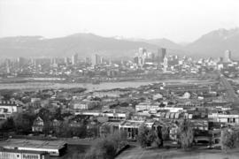
Downtown cityscape over Fairview and False Creek
Part of City of Vancouver fonds
Item part is a photograph of downtown Vancouver over Fairview and False Creek. The Granville Street Bridge and the Burrard Street Bridge are visible at the far left.

Downtown cityscape over Fairview, and False Creek
Part of City of Vancouver fonds

Downtown cityscape over Fairview, and False Creek
Part of City of Vancouver fonds

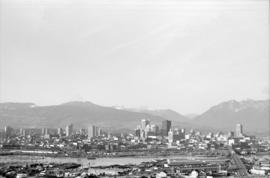
Downtown cityscape over Mount Pleasant and False Creek
Part of City of Vancouver fonds

Downtown cityscape over Mount Pleasant, Fairview, and False Creek
Part of City of Vancouver fonds
Item part is a photograph of downtown Vancouver, including a view down Cambie Street across the Cambie Street Bridge, and adjacent neighborhoods in Fairview and Mount Pleasant.

Downtown cityscape over Mount Pleasant, Fairview, and False Creek
Part of City of Vancouver fonds
Item part is a photograph of downtown Vancouver, including a view down Cambie Street across the Cambie Street Bridge, and adjacent neighborhoods in Fairview and Mount Pleasant.

Downtown cityscape over Mount Pleasant, Fairview, and False Creek
Part of City of Vancouver fonds
Item part is a photograph of downtown Vancouver, including a view down Cambie Street across the Cambie Street Bridge, and adjacent neighborhoods in Fairview and Mount Pleasant.
Downtown cityscape over Mount Pleasant, Fairview, and False Creek
Part of City of Vancouver fonds
Item part is a photograph of downtown Vancouver, including a view down Cambie Street across the Cambie Street Bridge, and adjacent neighborhoods in Fairview and Mount Pleasant.

Downtown cityscape over Mount Pleasant, Fairview, and False Creek
Part of City of Vancouver fonds
Item part is a photograph of downtown Vancouver, including a view down Cambie Street across the Cambie Street Bridge, and adjacent neighborhoods in Fairview and Mount Pleasant. The Granville Street Bridge and the Burrard Street Bridge are visible at the far left.

Downtown cityscape over Mount Pleasant, Fairview, and False Creek
Part of City of Vancouver fonds
Item part is a photograph of downtown Vancouver, including a view down Cambie Street across the Cambie Street Bridge, and adjacent neighborhoods in Fairview and Mount Pleasant.

Downtown cityscape over Mount Pleasant, Fairview, and False Creek
Part of City of Vancouver fonds
Item part is a photograph of downtown Vancouver, including a view down Cambie Street across the Cambie Street Bridge, and adjacent neighborhoods in Fairview and Mount Pleasant.

Downtown cityscape over Mount Pleasant, Fairview, and False Creek
Part of City of Vancouver fonds
Item part is a photograph of downtown Vancouver, including a view down Cambie Street across the Cambie Street Bridge, and adjacent neighborhoods in Fairview and Mount Pleasant.

Downtown cityscape over Mount Pleasant, Fairview, and False Creek
Part of City of Vancouver fonds
Item part is a photograph of downtown Vancouver, including a view down Cambie Street across the Cambie Street Bridge, and adjacent neighborhoods in Fairview and Mount Pleasant. The Granville Street Bridge and the Burrard Street Bridge are visible at the far left.
Downtown cityscape over Mount Pleasant, Fairview, and False Creek
Part of City of Vancouver fonds
Item part is a photograph of downtown Vancouver, including a view down Cambie Street across the Cambie Street Bridge, and adjacent neighborhoods in Fairview and Mount Pleasant.

Downtown cityscape over Mount Pleasant, Fairview, and False Creek
Part of City of Vancouver fonds
Item part is a photograph of downtown Vancouver, including a view down Cambie Street across the Cambie Street Bridge, and adjacent neighborhoods in Fairview and Mount Pleasant. The Granville Street Bridge and the Burrard Street Bridge are visible at the far left.

Downtown cityscape over Mount Pleasant, Fairview, and False Creek
Part of City of Vancouver fonds
Item part is a photograph of downtown Vancouver, including a view down Cambie Street across the Cambie Street Bridge, and adjacent neighborhoods in Fairview and Mount Pleasant.
![[Downtown Vancouver street scene with Marine building]](/uploads/r/null/4/0/4022508437b800627d5e19ab284b1c552184373beaf278f5e2059c01629519d9/c909be8a-510d-4030-9ff6-17e497ec6768-2008-022_142.jpg)
[Downtown Vancouver street scene with Marine building]
Part of Leslie F. Sheraton fonds
![[Downtown Vancouver street scene with Marine building]](/uploads/r/null/0/8/0859d8131b37f60064df6c8bde4a931c1532d5f6b32cd1930efb3fa24dee0379/683dfb91-1fd4-4e67-ae7f-fe05a4bbed8f-2008-022_142.jpg)
[Downtown Vancouver street scene with Marine building]
Part of Leslie F. Sheraton fonds

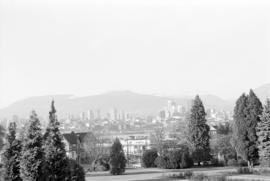
Downtown view over Fairview neighborhood
Part of City of Vancouver fonds
Item part is a photograph of the top of the downtown Vancouver skyline over the trees of a Fairview neighborhood. This photograph was taken from one of the lower floors of the Plaza 500 Hotel & Convention Centre.
Downtown view over Fairview neighborhood
Part of City of Vancouver fonds
Item part is a photograph of the top of the downtown Vancouver skyline over the trees of a Fairview neighborhood. This photograph was taken from one of the lower floors of the Plaza 500 Hotel & Convention Centre.

Downtown view over Fairview neighborhood
Part of City of Vancouver fonds
Item part is a photograph of the top of the downtown Vancouver skyline over the trees of a Fairview neighborhood. This photograph was taken from one of the lower floors of the Plaza 500 Hotel & Convention Centre.
![[Eastward view of downtown from the Terminal City Club, 837 Hastings Street, showing Pier D]](/uploads/r/null/9/5/9523884236697e596af802e7cf7ced23b8df0cd4ef660a464f06c85f65edffda/1378bd7b-721e-4359-9c81-115ebad704ee-A63887_142.jpg)
[Eastward view of downtown from the Terminal City Club, 837 Hastings Street, showing Pier D]
Part of Major Matthews collection

Expo '86' - press release footage
Part of Yaletown Productions Inc. fonds
Item consists of raw footage featuring B.C./Expo 86 aerials; shot in 35mm and transferred to one inch tape. Original negative no longer exists and only video footage survives. Some of this material was used in Yaletown Production's video postcard series.

Geographical : Aerial of Vancouver
Image shows aerial view of the West End and West Side of Vancouver.

Image shows an aerial view of the west end of Vancouver looking south.

Image shows aerial view of Vancouver and North Shore.

Image shows an aerial view of the West End and West Side of Vancouver.
![Granville Street [looking towards Robson Street]](/uploads/r/null/e/e/a/eea903b042f259aa6d941c1a003aaaa1fc95fddb720b155c6e41da1c67a2b2aa/3d105e31-257c-452f-a149-87b6897a7764-CVA220-05_142.jpg)
Granville Street [looking towards Robson Street]
![Habitat - Ivanhoe Hotel - #56 [10 of 31]](/uploads/r/null/7/9/1/79187ba2b9280978628c0eaa7bab67f506b302ad290d4e90c1b93b55f4d925ed/b54066f9-1e03-4f7f-99a2-951feae08228-CVA395-01886_142.jpg)
Habitat - Ivanhoe Hotel - #56 [10 of 31]
Part of Habitat Forum photographs
![Habitat - Ivanhoe Hotel - #56 [11 of 31]](/uploads/r/null/3/4/3/343131eeb2aaac5fdd855891932a8bbdb85942b2aaab49a9d9b46eb300246702/6e5ba324-3f36-4923-8580-4ab60e00d5ee-CVA395-01887_142.jpg)
Habitat - Ivanhoe Hotel - #56 [11 of 31]
Part of Habitat Forum photographs
![Habitat - Ivanhoe Hotel - #56 [12 of 31]](/uploads/r/null/7/e/0/7e08c0e5c60ec96b8ffbccb270ec89bad4a06dda42e2248a1749a1f7b67bea7e/72e581ca-3389-4589-9ef9-f132cb954219-CVA395-01888_142.jpg)
Habitat - Ivanhoe Hotel - #56 [12 of 31]
Part of Habitat Forum photographs
![Habitat - Ivanhoe Hotel - #56 [13 of 31]](/uploads/r/null/3/b/0/3b037663d30fa8ffb8fa50e2865365341ce137d2be5c1a0fa03c0ac6b1fac1e7/6c5ac25f-ac2d-479f-b68a-27a8e2bf8290-CVA395-01889_142.jpg)
Habitat - Ivanhoe Hotel - #56 [13 of 31]
Part of Habitat Forum photographs
![Habitat - Ivanhoe Hotel - #56 [4 of 31]](/uploads/r/null/1/5/4/154ceb23072ee94afe5b796d70d3cfa984cf92e0799bed384a8516a1020b9029/377306e8-2d19-46a6-8955-27002dba837b-CVA395-01880_142.jpg)
Habitat - Ivanhoe Hotel - #56 [4 of 31]
Part of Habitat Forum photographs
![Habitat - Ivanhoe Hotel - #56 [5 of 31]](/uploads/r/null/d/7/5/d7589c3adace2e814eeca031116669b1733a47b4010ea0af7e182a00faf9a1e3/d7ebe02e-2ac6-47a6-9073-1f7f7daaf02b-CVA395-01881_142.jpg)
Habitat - Ivanhoe Hotel - #56 [5 of 31]
Part of Habitat Forum photographs
![Habitat - Ivanhoe Hotel - #56 [8 of 31]](/uploads/r/null/2/4/2/242a6ddb64033d1e3a91a5f621fe06b601f5f32b7ccf22eb357ceeff67fe2abb/aaef01c7-cdfd-45d0-a5fe-18ef95764cba-CVA395-01884_142.jpg)
Habitat - Ivanhoe Hotel - #56 [8 of 31]
Part of Habitat Forum photographs
![Habitat - Ivanhoe Hotel - #56 [9 of 31]](/uploads/r/null/3/2/f/32f63c14d1a3f7cd5672535efc88cf6fffbf335cd3645aefc7ac5ec62d868cd8/2fc28085-6f17-4981-9a61-174203aa7c5b-CVA395-01885_142.jpg)
Habitat - Ivanhoe Hotel - #56 [9 of 31]
Part of Habitat Forum photographs
![Hastings Street [at Granville Street, looking east]](/uploads/r/null/c/3/e/c3e0e80033bfc1abe619f2ef7c52c9335d199208a69ea9aa6a369120dc64089b/7e3916d1-d8a3-4f0b-9547-2d0c4ed09967-CVA220-11_142.jpg)
Hastings Street [at Granville Street, looking east]
![Hastings Street [looking towards Cambie Street intersection]](/uploads/r/null/3/2/1/321d1b6a2b28a3768524ccca75a7d5c5bf74fe813311eb2b0ec7a1b6e0d0dc32/2e33cb15-ca00-44d6-86f6-42cd3209f4e3-CVA220-10_142.jpg)
Hastings Street [looking towards Cambie Street intersection]
![Hastings Street [looking west to corner of Hastings and Granville Streets]](/uploads/r/null/a/1/4/a1413802d2e8896d75397a4e4edb6fee463593df335a949c3ea89543d5c901ce/9e41b343-61f9-4493-bbca-73e6d04bafc4-CVA220-06_142.jpg)
Hastings Street [looking west to corner of Hastings and Granville Streets]

Landscape - general : skyline Vancouver?

Landscape - general : Vancouver at night

Landscape - general : Vancouver skyline from VanDusen
![Looking across the [Coal] Harbour [to Brockton Point.]](/uploads/r/null/f/7/2/f72ebde6973e8ae052822e96465091023795f271b3b3049bb7a0485920e4655b/dea675cc-5e38-431b-98e5-f2b0de4bdef8-CVA294-082_142.jpg)
Looking across the [Coal] Harbour [to Brockton Point.]
Part of Bertram Emery fonds

Looking down Granville Street, Rogers Building on right, C.P.R. Station in distance

Panoramic view. Image is one of two panoramas mounted on board to show the changes in the cityscape between circa 1890 and 1923.
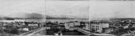
Panoramic view. Image is one of two panoramas mounted on board to show the changes in the cityscape between circa 1890 and 1923.