
Vancouver section 13 supplementary information
- COV-S167---: LEG1153.456-: LEG1153.456.024
- Part
- 1947
Part of City of Vancouver fonds
Part is a sheet showing information noted about assessments and other information relevant to Vancouver section 13.
504 results with digital objects Show results with digital objects
Vancouver section 13 supplementary information
Part of City of Vancouver fonds
Part is a sheet showing information noted about assessments and other information relevant to Vancouver section 13.

Part of City of Vancouver fonds
Part is a section depicting the area bounded by Clark Drive to Fourth Avenue to Ontario Street to Sixteenth Avenue. The sheet has been extensively annotated, with colour coded areas to depict land use, status of lots as tax sale properties for sale, sewer and water lines, as well as other colour codes that are not noted on the legend at the front of the volume.
Vancouver section 12 supplementary information
Part of City of Vancouver fonds
Part is a sheet showing information noted about assessments and other information relevant to Vancouver section 12.

Part of City of Vancouver fonds
Part is a sheet depicting the area bounded by Clark Drive to Keefer Street to Ontario Street to Third Avenue. The sheet has been extensively annotated, with colour coded areas to depict land use, status of lots as tax sale properties for sale, sewer and water lines, as well as other colour codes that are not noted on the legend at the front of the volume.

Vancouver section 11 supplementary information
Part of City of Vancouver fonds
Part is a sheet showing information noted about assessments and other information relevant to Vancouver section 11.

Part of City of Vancouver fonds
Part is a section depicting the area bounded by Clark Drive to Burrard Inlet to Carrall Street to Keefer Street. The sheet has been extensively annotated, with colour coded areas to depict land use, status of lots as tax sale properties for sale, sewer and water lines, as well as other colour codes that are not noted on the legend at the front of the volume.

Vancouver section 10 supplementary information
Part of City of Vancouver fonds
Part is a sheet showing information noted about assessments and other information relevant to Vancouver section 10.

Part of City of Vancouver fonds
Part is a section depicting the area bounded by Slocan Street to Burrard Inlet to Clark Drive end to Triumph Street. The sheet has been extensively annotated, with colour coded areas to depict land use, status of lots as tax sale properties for sale, sewer and water lines, as well as other colour codes that are not noted on the legend at the front of the volume.

Part of City of Vancouver fonds
Part is a section depicting the area bounded by Boundary Road to Burrard Inlet to Slocan Street to Triumph Street. The sheet has been extensively annotated, with colour coded areas to depict land use, status of lots as tax sale properties for sale, sewer and water lines, as well as other colour codes that are not noted on the legend at the front of the volume.

Part of City publications collection

Vancouver Parks and Recreation : map and guide
Part of City publications collection
Part contains a map of Vancouver showing major roadways and locations of attractions advertised in the pamphlet, a map of Stanley Park in more detail, and textual information on Stanley Park and Vancouver beaches.
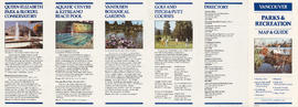
Vancouver Parks and Recreation : map and guide
Part of City publications collection
Part contains information about Vancouver attractions including Queen Elizabeth Park, the Vancouver Aquatic Centre, VanDusen Botanical Gardens, and golf courses.

Vancouver Parks and Recreation : a guide to services
Part of City publications collection

Vancouver Parks and Recreation : a guide to services
Part of City publications collection

Part of City publications collection

Vancouver city and suburban lines
Part of City of Vancouver Archives technical and cartographic drawing collection
Part is the back side of an informational pamphlet published by the BC Electric Railway Co. showing street car lines, interurban lines, bus routes and parks.

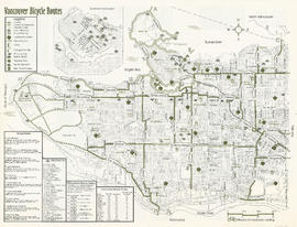
Part of City publications collection
Part contains a map of Vancouver bicycle routes with a key to attractions, bridges and ferries, and downtown bicycle parking locations. An inset map shows Downtown Vancouver in more detail.

Part of City publications collection
Part contains a map of the north half of Vancouver (Burrard Inlet to 22nd Avenue) showing bicycle routes, parks, and SkyTrain stations, and textual information on downtown bicycle parking and combining cycling with public transit.
Part of City publications collection
Part contains a map of Vancouver bicycle routes with a key to attractions, bridges and ferries, and downtown bicycle parking locations. An inset map shows Downtown Vancouver in more detail.

Part of City publications collection
Part contains a map of the south half of Vancouver (22nd Avenue to the Fraser River) showing bicycle routes, parks, and SkyTrain stations, a list of useful contacts for cyclists, and information on bridges and connections.

Vancouver - the third largest city of the dominion, and Canada's chief Pacific port
Part of City of Vancouver Archives technical and cartographic drawing collection
Part contains information on Vancouver's history and government, and on the purpose and benefits of town planning.

Tourist map of Greater Vancouver
Part of City of Vancouver Archives technical and cartographic drawing collection
Part is a sheet with two maps. The main map shows a pictorial view of Greater Vancouver, including the location of major roads and tourist attractions. Drawings of "the most important single objects on totem poles of the Pacific Northwest Indians" form a decorative border. The inset map shows downtown Granville Street and the location of the Scenery Shop.
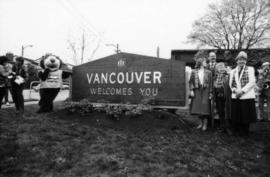
Tillicum, Linda Graham, Mike Harcourt and two unidentified women beside sign

Tillicum, Linda Graham, Mike Harcourt and three unidentified people beside sign

Tillicum, Linda Graham, Mike Harcourt and three unidentified people beside sign

Tillicum, Linda Graham, Mike Harcourt and three unidentified people beside sign

Tillicum, Linda Graham, Mike Harcourt and three unidentified people beside sign


Tillicum and Mike Harcourt beside sign

Tillicum and Mike Harcourt beside sign

Tillicum and Mike Harcourt beside sign
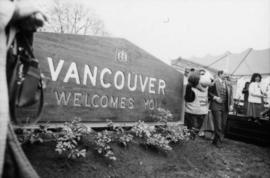
Tillicum and Mike Harcourt beside sign

Tillicum and Mike Harcourt beside sign

Tillicum and Mike Harcourt beside sign
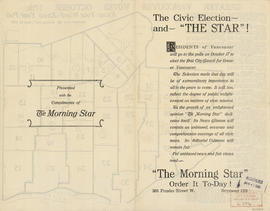
The civic election - and "The Star"!
Part of City of Vancouver Archives technical and cartographic drawing collection
Part contains text advertising The Morning Star newspaper and assuring readers of its political neutrality.

The civic election - and "The Star"!
Part of City of Vancouver Archives technical and cartographic drawing collection
Part contains text advertising The Morning Star newspaper and assuring readers of its political neutrality.

Street map of Greater Vancouver showing distances from Bekins building
Part of City of Vancouver Archives technical and cartographic drawing collection

Street map of Greater Vancouver : map cover, street index and advertisements
Part of City of Vancouver Archives technical and cartographic drawing collection


Street index (Royal Oak Avenue, Vancouver to Frederick Road, North Vancouver)
Part of City of Vancouver Archives technical and cartographic drawing collection
Part contains two pages from the booklet accompanying a guide map of Greater Vancouver. Pages include the last portion of the Vancouver and Burnaby street index, the New Westminster street index, and the North Vancouver street index from 1st Street to Frederick Road.

Street index of Vancouver and Lower Mainland
Part of City of Vancouver Archives technical and cartographic drawing collection

Street index (Campbell Street to Rosser Avenue)
Part of City of Vancouver Archives technical and cartographic drawing collection
Part contains two pages from the booklet accompanying a guide map of Greater Vancouver.

Site of sign unveiling with sign under tarp
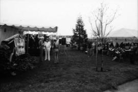
Site of sign unveiling with sign under tarp
![Sheet 9D [Slocan Street to Grandview Highway to Marshall Street to 22nd Avenue]](/uploads/r/null/b/1/c/b1c4c0bbf98c9c2ff5a2e60e8350582f0e591688b2f9670ba1f4aaecc638b227/7e2aefcc-f31d-4c11-a0ae-1293bd850528-LEG1153_142.jpg)
Sheet 9D [Slocan Street to Grandview Highway to Marshall Street to 22nd Avenue]
Part of City publications collection
![Sheet 9C [Hull Street/Semlin Drive to 14th Avenue to Clark Drive to 22nd Avenue]](/uploads/r/null/b/4/8/b48f272549a65e8622204f5c1a677afad16a9ef19306e9696b31ef6d9c08cf16/c56229a4-c4b1-492d-b215-b5b53f060d69-LEG1153_142.jpg)
Sheet 9C [Hull Street/Semlin Drive to 14th Avenue to Clark Drive to 22nd Avenue]
Part of City publications collection
![Sheet 9B [Slocan Street to 6th Avenue to Semlin Drive to 14th Avenue]](/uploads/r/null/b/7/5/b75c61b603e8ab998f68941a380457aeae4de4affd845d40405472b07f3738a2/140ef05a-e687-4959-a97a-2765c7610a3c-LEG1153_142.jpg)
Sheet 9B [Slocan Street to 6th Avenue to Semlin Drive to 14th Avenue]
Part of City publications collection
![Sheet 9A [Semlin Drive to 6th Avenue to Clark Drive to 14th Avenue]](/uploads/r/null/4/b/8/4b83338cc19b64deb790aac94219d77731e8a711697a611a458656793c63ccda/f3604bbf-e839-474f-a033-6569d2f2d2e0-LEG1153_142.jpg)
Sheet 9A [Semlin Drive to 6th Avenue to Clark Drive to 14th Avenue]
Part of City publications collection
![Sheet 8D [Slocan Street to Charles Street to Semlin Drive to 6th Avenue]](/uploads/r/null/9/f/b/9fb954e03525c1c5f3722cf6d1f3b0e0d9ae28c2a0ed307fa25ca0dc6ac46434/416c089e-39ae-49d3-a4fc-472175911de5-LEG1153_142.jpg)
Sheet 8D [Slocan Street to Charles Street to Semlin Drive to 6th Avenue]
Part of City publications collection