
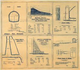
Cheakamus River valley with possible dam location
- COV-S40-MAP 939-: LEG1153.031
- Item
- [1931]
Part of City of Vancouver fonds
Item is a sheet with three maps depicting a possible dam site on the Cheakamus River: a topographical map of the site with the dam location annotated, a cross-section depicting the geology of the dam site, and a profile of the tentative location of a tunnel.


![[Cisco Bridge and Fraser River]](/uploads/r/null/a/2/a231a3df1ccf484d489689154c51058b523fad34415b5cd98dbf549b44237cfa/1837776e-8fc0-422c-b5be-0ba695ae4d6c-A04528_142.jpg)
![[Cleared hillside and partially completed wooden structure next to stream]](/uploads/r/null/0/4/0442a8ff2747c97bce733ff53234a2e453f90f9f372b69a1e36bcda7986db1a5/ebc2b82f-4c28-4e46-bd75-5ddb962cf022-A04824_142.jpg)


![[Cliff and river], Capilano Canyon](/uploads/r/null/3/e/3e8447ddcb3c0c7a0232c20f6608f812fb77b7b15f6990c0ebad31889b21c276/ab17e8d9-a24a-4cfe-acc2-849b1fe0647b-A02692_142.jpg)


![Columbia River [Kicking Horse River] near Golden](/uploads/r/null/1/6/c/16cfc9a2b9ccef48e7169ce23eb1172867a6f7e797c2103240a7720f36f4510d/de019715-a354-4f85-aeb1-fb202e754045-CVA260-1562_142.jpg)


![Columbia River, south from [road]](/uploads/r/null/5/6/7/5670195d2de94762b4f109d3a418369b5336f78561f2a4469b39b1832adbaec7/44846721-0d90-442b-ba11-65cdce7de47e-CVA256-02_142.jpg)


![Coquitlam Dam [showing] first rapids, Schuyler Creek](/uploads/r/null/a/1/a17fd98eeb910e95f314c9676f6c8971cba23877a18330cc35c3543944db69c7/13ecb68a-7bd6-4861-b1cd-4039e5e3cfdf-A32940_142.jpg)
![Coquitlam Dam [showing] view downstream from east bank over spillway](/uploads/r/null/8/e/8ed0843af1ad35cee72192f60ec7b36c45244c3acb4a23a26b223ff19e9e8cbe/56af211f-2b69-482f-a6be-cb6cfcf8735f-A32902_142.jpg)


![Courtenay River [on] Vancouver Island](/uploads/r/null/a/1/a171b5097bf99be78bec10ac43b1c93417f5ca4cf635279950c632305a7f8187/22e3d9ac-9ebf-4305-8a70-bf4ffd1be553-A76338_142.jpg)
![[Cow grazing near a stream]](/uploads/r/null/7/6/4/764f8fce0ac87ad817087c7590b9853b7f9d7d87c56269d2e761c3c66f19fdc8/23ebc97c-5ffb-45a7-9fd8-9da82ed6472e-CVA260-1981_142.jpg)


![[C.P.R. Hotel at Banff, seen from across the Bow River]](/uploads/r/null/9/f/c/9fc11cd629ff2c3a433fb3bd583218bb3225db4f6821ef8d9a1d4e67c4cce2d1/81fcd907-df48-4126-863c-7addb8c82358-LGN595_142.jpg)
![C.P.R. Hotel from across the Bow [River]](/uploads/r/null/d/3/d3a80de5b951f1842415374308c3a996d505e2e41da6e75237d796f48373a3c0/db67449f-16bd-482f-8c40-73bfb8fb65fa-A20027_142.jpg)


![[Creek near] C.J. Piper's cottage [on] Piper [Avenue] south of G.N.R. track North Burnaby](/uploads/r/null/b/0/b07a3a285c36eeb39d1a022d09cfd4079ebdb5c56421cae66bda8e85b95e3c9f/f1ccade7-c066-4825-84be-c0de420f1c9e-A46623_142.jpg)

![[Creek running over rocks on Bowen Island]](/uploads/r/null/7/4/743b14ebc321aec8d3e889fdede5021b32ad1ead3b021f069f9a3ba9998edad8/b2a4eb9f-5330-437a-9a72-4a1327dbe899-A13887_142.jpg)
![[Cribbing on road at edge of Capilano Creek]](/uploads/r/null/a/3/a359362e8107f6a8feb33a5b82762ea3906af278d6f024af920dd189ce5d2593/ba3f6329-5973-4d12-96d2-90a0a3909935-A16597_142.jpg)


