![[A flat car on rails near Buntzen Lake]](/uploads/r/null/e/f/ef36a170a63a935a30c10ba410111411f26c6dee81f28781afc2c197c1dd0d07/f2d6e83d-addc-4d66-b8df-4a49f6da1031-A23290_142.jpg)
[A flat car on rails near Buntzen Lake]
![[A railroad above a wagon road]](/uploads/r/null/5/6/1/5611125c0239a28ff429071c5e373a96c8c7e60a5ed0520f7f7594edb46a3bb0/7f3cef61-3a82-47d1-b07e-ccb3db87617d-CVA260-1111_142.jpg)
[A railroad above a wagon road]
![[An unidentified trestle bridge]](/uploads/r/null/3/9/39fdfa01a84339614eb65f280a452762a43e4d2ca6702d013f6aab7d6d942585/af3f3987-8c1b-41a5-a221-c2508a177dab-A62874_142.jpg)
[An unidentified trestle bridge]
![[An unidentified trestle bridge]](/uploads/r/null/e/b/eb0d4c8b0dae85193566cd43b486ff6bbfed301718582e19f02af491568cc2fb/0ad7459c-1972-4393-bca8-624dbe2c4fe4-A62875_142.jpg)
[An unidentified trestle bridge]

Beaver Canyon, B.C.

Beaver Canyon, B.C.

Beaver Canyon, B.C.
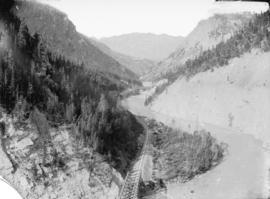
Bird's eye view Lower Kicking Horse Canyon
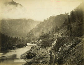
Bluffs, 2 1/2 miles above Yale looking down valley

British Columbia railway belt
![[Buntzen Lake Dam under construction]](/uploads/r/null/8/9/89e05851fc9849500789e66325ccbb0dab13cebec4618829b8683b45363b0e5e/16b1c6e9-1b1d-4efe-9699-11f9b4398b52-A23315_142.jpg)
[Buntzen Lake Dam under construction]
![[Canadian Pacific rail line along the Fraser River]](/uploads/r/null/f/5/f5068a6b7c226036874b05895a1ce07e51790a03e2d69a53f27e91e33c04121d/ce9b2c39-5dcc-4d47-ada8-79bc292af478-A03866_142.jpg)
[Canadian Pacific rail line along the Fraser River]

Cascade Mountain

C.P.R. Bridge, White's Creek, Fraser Canyon

C.P.R. cantilever bridge across Fraser River 52 miles above Yale

C.P.R. cantilever bridge across Fraser River 52 miles above Yale

C.P.R. crossing Skuzzy River, Fraser Canyon
![[C.P.R. line through tunnels in mountain]](/uploads/r/null/f/8/f802e445bc29c0f27d847b0ce332297a0f6a0df7c77b32cf2de2d0c394b5f8b2/8905d2db-8786-4bc7-b04d-90363315a3f7-A07963_142.jpg)
[C.P.R. line through tunnels in mountain]

C.P.R. train going east
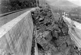
![[Debris over railway tracks during flooding of the Fraser River]](/uploads/r/null/0/1/01847f2fb7d8caf15febc73957867715f62869873b9c8413e3569950b84d26cc/0815196e-62eb-4206-b7ca-06a285886f49-A60577_142.jpg)
[Debris over railway tracks during flooding of the Fraser River]
![[Debris over railway tracks during flooding of the Fraser River]](/uploads/r/null/9/0/90fe092f5f241878f2ae538a7a6cb1e5e2158fd5ec080a774b31604183fd14bf/81f35939-d5d7-4ee7-ab59-85ae9e5c4602-A60578_142.jpg)
[Debris over railway tracks during flooding of the Fraser River]

"Deep Creek Bridge P.G.E."
![Devil's Gap [and] Beaver Canyon View No. 2](/uploads/r/null/4/4/44d0528e595370f28fc2340079698113fd07efcd4c94dca50739bca01fccf576/c7c99282-4843-4adf-822c-539477e63eb9-A19771_142.jpg)
Devil's Gap [and] Beaver Canyon View No. 2
![[Driving the last spike of the Pacific Great Eastern Railway line 25 miles north of Horseshoe Bay]](/uploads/r/null/8/6/865249cd08465450446cf3fbba7cb5f3835813180d9172e6001e6fd65f64a12c/04e7f1a8-6f42-4a37-a8c0-632d0027d414-A37620_142.jpg)
[Driving the last spike of the Pacific Great Eastern Railway line 25 miles north of Horseshoe Bay]
![[Elevated rails at the Buntzen Lake Dam construction site]](/uploads/r/null/9/9/99f876a0f7c5ea020f86be1134bd5ee9f41dbeefffe4a5bead61539e75c10301/df189970-2db0-4372-90fd-d40ff41ccf45-A23312_142.jpg)
[Elevated rails at the Buntzen Lake Dam construction site]

First Curve on Loop Going West, Selkirks
![[Floating rails on Buntzen Lake]](/uploads/r/null/9/4/94d3de2029b4cefd1b7c3546b7a0c026c33eb4536b25774518bee87d95505802/a703e912-68eb-465f-8c81-a88683ee637c-A23296_142.jpg)
[Floating rails on Buntzen Lake]
![[Flooding] East of Agassiz](/uploads/r/null/9/0/9026779ba4b27629323676cc03d3d37ba9282654f12d890d7d481a72c1b3b3cf/a825f68e-00ee-4198-8bc4-3ebef6aeb9b5-A33076_142.jpg)
[Flooding] East of Agassiz
![[Flooding] West of Harrison [River]](/uploads/r/null/1/5/1585f33739747cd7f7d0cdc779abda00522bfe13d09630d253e504b7de4b5752/3e0d9626-58af-4fb8-b92e-dbf04fd1ecc1-A33073_142.jpg)
[Flooding] West of Harrison [River]

Fraser Canyon
![Harrison [River flood]](/uploads/r/null/e/7/e7e8221ae477cb44cccb068dd6aeca6b37be6c20182d659cbef886ad14593b9c/480e6c13-3fcc-4887-8b70-0341237bc377-A33074_142.jpg)
Harrison [River flood]

Hermit Range and snow sheds, from summit of Selkirks, C.P.R.

Hermit Range from Snow Sheds, Selkirks
![Hermit Range, from summit of [Selkirks, C.P.R.]](/uploads/r/null/a/a/aaef5746df63939614fccd5d4a0c8a1417d3fa0c5dc24a6f2831154e619e4d52/e8367f9c-8d45-4d1b-8edf-37715a00045a-A07993_142.jpg)
Hermit Range, from summit of [Selkirks, C.P.R.]

Illecillewaet Valley from Observation Point, Glacier, B.C.
In the upper Fraser Valley

Kicking Horse Pass, Rockies
![Looking across Loop, Selkirk M[ountains]](/uploads/r/null/e/2/e275bb85c47afed5b2d207613d4e79766f9afed2a1edffc57266d6ae5f770c75/49b681b5-70aa-49af-8968-00e6144e138a-A19423_142.jpg)
Looking across Loop, Selkirk M[ountains]
![Loop, C.P.R. Selkirk M[oun]t[ain]s, showing four tracks](/uploads/r/null/b/0/b0a0cf5ee473bc74bbea9f30cb21753320f8c5e3dda92cf26b3f776daec2397e/22db0e41-8a5f-462f-9988-1bf40dfabcc6-A19463_142.jpg)
Loop, C.P.R. Selkirk M[oun]t[ain]s, showing four tracks
!["Loop," C.P.R., Selkirk M[ountains]](/uploads/r/null/9/4/9467229e1860d76119fc10341e39761633ad8c254f6a685743f7e26eb1fc49db/d8e72391-0290-4ea1-bc52-69429979a234-A19424_142.jpg)
"Loop," C.P.R., Selkirk M[ountains]

Lower Kicking Horse Canyon near Golden, B.C.

Lumber Sheds

Map of Manitoba, Keewatin, British Columbia, and North West Territory

Map of Manitoba, Kewaydin, British Columbia and North West Territory shewing the country traversed by the Canadian Pacific Railway
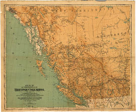
Map of the Province of British Columbia

[Men working on C.P.R. railway line uphill from the Nose tunnel in Mt. Stephen, on the Big Hill east of Field, B.C.]

Mount Hermit Summit of Selkirks Height 9680 feet

Mount Hermit, C.P.R., Selkirks, Midwinter, Height 9680 feet
![Mount McDonald [MacDonald], C.P.R., Selkirks, midwinter, height 9440 ft.](/uploads/r/null/a/b/ab2a6f9761da72be5b95cc7c26b9134cbc9556ef110fbbd2a31bb79f4a574ee5/63e110ea-430d-46c2-add5-934dd2594853-A04166_142.jpg)
Mount McDonald [MacDonald], C.P.R., Selkirks, midwinter, height 9440 ft.

Mount Sir Donald