
Vancouver : as seen from space : vue de l'espace
- AM1594-: MAP 1187
- Item
- 1986
Part of City of Vancouver Archives technical and cartographic drawing collection
Map shows Vancouver, the Fraser Valley and a portion of the Gulf Islands as seen from space.
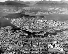
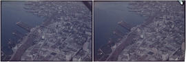
![Vancouver [aerial view of Downtown, Vancouver waterfront and Burrard Inlet looking northeast]](/uploads/r/null/1/7/17c9a12fb86cf85b5f4fd0c94d870a13f459a539954cada4c2e55fc4bf8212ca/9b12d330-c054-4553-bc9e-684e1701d35b-A49464_142.jpg)
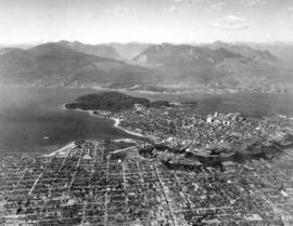
![Vancouver B.C. [from the air looking east from West End]](/uploads/r/null/a/3/a39a59fafd2c470a05e0b8ecba90843c0dcefd64faa8cd1695e25e8515c52ad7/4a63a71b-9508-45ea-b75a-27924fe36db8-A42964_142.jpg)

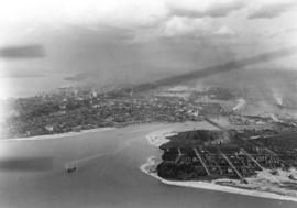
![Vancouver looking east from [Howe Sound]](/uploads/r/null/6/6/66fa4a6e8bb1ab5d20d8f951fa93ad57dd828be645aff6d182d88a8b36c69281/69bee6e1-54a6-4c8f-a7db-043e03b4dfe6-A23503_142.jpg)


![Vancouver, B.C. Cambie Br. [bridge]](/uploads/r/null/d/a/9/da9942388ff02d1a8b65d1bfeb1c75a017e0cd4ae269e5557f50a4cb73df2adc/9b8ee4bb-f63f-4874-9e80-aeb2fd1058c2-2014-055_142.jpg)
![Vancouver, B.C. Cloverleaf - N. [north] End Granville Bridge](/uploads/r/null/a/1/c/a1ca23293aba4a0df735121e9f46a98d76eaf6d0141da0d7cf5437c9a109c4b6/1a0404fe-80ee-4ef0-8cae-911f5ab9c506-2014-055_142.jpg)
![Vancouver, B.C. Connaught Br. [Cambie Bridge] and west](/uploads/r/null/8/1/2/812afcfdc1ae047980e6d5f922d44782e2cc8b2e14671603fe495311c69a4120/22405b60-cda0-4fc6-bd59-01a4219b4892-2014-055_142.jpg)
![Vancouver, B.C. East of N. [north] End of Lion's Gate Br. [bridge]](/uploads/r/null/6/c/1/6c17477fe4843e6552e79e511c4a8ea7aeb8ec20926264b8101326b6d03700e6/f3eca68f-c724-4044-8bce-bb4d229a2568-2014-055_142.jpg)
![Vancouver, B.C. [from the air looking east from Lost Lagoon]](/uploads/r/null/5/1/5127fcacb95395f95ba7c0f104a40a408b7f3d76e10c9881ebcc71cfc1a7c5de/ee54b68d-1f24-417f-b491-0956e3d4522f-A42965_142.jpg)
![Vancouver, B.C. N. [north] End Lion's Gate Bridge](/uploads/r/null/6/f/e/6feff36adf72e7a2b8184d907d1a619f3fb3c9d6f42e1f57abe09c79289129ac/51d5d38f-bf43-4380-8c69-4134019a091c-2014-055_142.jpg)
![Vancouver, B.C. N. [north] W. [west] of Burrard Bridge](/uploads/r/null/c/9/b/c9bc62f0498b0fd931c76b545c4eaaf97dd1b608f5d18f97f2f49f032f47eba1/65847175-475d-4b72-b005-c9bed2aa284d-2014-055_142.jpg)


![[View looking east from Main Street and Pender Street]](/uploads/r/null/8/0/809cf6a26840094bf6d8fe3ddd67086496a879a0bb94d26685982dda7e6f42a7/0bafdc9e-9e34-4fc8-9e04-8b7bcfd96944-A43299_142.jpg)
![[View looking northeast from north shore of False Creek over Smithe Street]](/uploads/r/null/8/f/6/8f6d7814ac04d1498743ba52bf07caf7e8dd2cf0290eb319665712b1edfdc180/c5c831e7-835b-48ff-8c87-5c157412dc0c-CVA145-2_142.jpg)
![[View of bomb damage to Coventry Cathedral]](/uploads/r/null/0/7/07d5146fb22e71cd6c44cbc1bd9eb92cfffdb821b5f8eab77d5b00b9fee8301a/e81d24df-fba1-40cc-8848-b5efa3cebf84-A31913_142.jpg)
![[View of Bowen Island showing the Union Steamship Co. Resort and Deep Bay]](/uploads/r/null/0/e/5/0e5fd0a3823f46a59fe85dbcede962ae9058bfeb8c6f495757597faf613f5a23/03e4b409-ae1e-4ae0-9f31-75211d5ba73f-CVA374-317_142.jpg)


![[View of] Dominion Mills, Ltd. South Vancouver, B.C.](/uploads/r/null/3/d/3df103cdd0c70f0cee1a01cdc4efef424d87ee1cc70cc1584551d8e4149d6e11/a0506029-def0-4762-b5d9-caf30483e8ab-CVA1376-25_142.jpg)
![[View of downtown Vancouver looking west]](/uploads/r/null/7/d/7dad7862dc87d31b1f2417a66c8ea3ec2a6043291daffccd93ffc8811f88af81/09c850ff-3ec3-440d-a2fd-cc45a34165d7-A23516_142.jpg)
![[View of farm buildings and fields taken from the air]](/uploads/r/null/9/b/9b1f700b1bdee44fb2534cdd56a164987f3e8bb21e6f247ae7822623a2df94dc/7d25fb85-64f0-4eca-a154-b9f6d0bc65bf-A13721_142.jpg)
![[View of fire at lumber yard - B.C. Forest Products fire?]](/uploads/r/null/9/b/b/9bb7b1121a5a4c910f4d3264b043a9f028cc0099a2b18e0f2606d798651b2662/edfdcb36-ab3c-4829-adf0-63aafb6fd88a-CVA354-416_142.jpg)
![[View of "Fram" house, museum and surroundings]](/uploads/r/null/a/2/a23e8d90b582fc81e46113cc01d88737de674f1b6fa6bd8e12e6c3893b9f57b8/57d1f05c-1c0a-46d2-bb67-76183b1f96d8-A24329_142.jpg)
![[View of Georgia Street looking east from Broughton Street]](/uploads/r/null/b/3/b36a0ffb562445ab07907f340f899fb198d3da341503d87325ba6f798192024b/5888eb3d-0b22-4147-b01a-3a4f70ddb45c-A23490_142.jpg)
![[View of northern France]](/uploads/r/null/1/9/195ad3c10a7ef65dd8ea2fb1da84894c8736ea2bec978133c9bab6b4b768c922/cc9aa259-d232-4509-a50d-c1f6e2ffe1fa-A26249_142.jpg)