
City of Vancouver, British Columbia
- COV-S365-: MAP 716
- Item
- Dec. 1959-Apr. 12, 1961
Part of City of Vancouver fonds
Item is a map showing city streets and address block numbers.
3815 results with digital objects Show results with digital objects
City of Vancouver, British Columbia
Part of City of Vancouver fonds
Item is a map showing city streets and address block numbers.

Part of City of Vancouver fonds
Image shows vacant lot in foreground, portions the Nelson Rooms and Nothingham Apartments in the 1200 block of Robson Street and the east side of the Sheraton Landmark building.

Part of City of Vancouver fonds
Image shows vacant lot in foreground and the back of the Nelson Rooms and the Nothingham Apartments.

Comox Street (looking East from Denman)
Item is a photograph on an album page, annotated with "A 'hit-and-miss' example of boulevard planting. Note the varieties of trees planted, size and age, and the gaps left unplanted."

Item is a photograph on an album page, annotated with "An example of conditions often met with. On the left (North side of street) the sidewalk is on the inside, with outer boulevard; on the right the sidewalk is constructed to the kerb, with inner boulevard. Proper boulevarding under such conditions is impossible. Note the forest maples planted closely together on the left and the occasional tree on the opposite side. An application is on file requesting the City to remove these trees entirely, so as to permit light and air to the houses and to make more effective street lighting at night."

Denman Street (between Nelson and Comox)
Item is a photograph on an album page, annotated with "In this block the heavy type of forest maple was planted on the inner boulevard. This is a typical instance of how the owners of the houses affected by such trees deal with them in their desire for light and air. NOTE: That in the next block is outer planting."
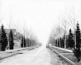
Item is a photograph on an album page, annotated with "Illustrating the pleasing effect of a properly and systematically planted boulevard."
![G.W. Ledingham, Contractor Laying Cement Sidewalks [in the 500 and 600 Blocks of Georgia Street]](/uploads/r/null/7/4/740ed1613cbefce7f771d3f07c8f236fb54edbbbdbfaac29821127ed4085bd52/5afb0890-78b9-4843-b03a-863a80358a20-A71515_142.jpg)
G.W. Ledingham, Contractor Laying Cement Sidewalks [in the 500 and 600 Blocks of Georgia Street]

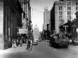
Granville Street, Vancouver, B.C.
Photograph shows a view looking north from Nelson Street including Kripps Drugs, Darlings Style Shop, Vogue Men's Wear, the signs for the Vogue Theatre, the New Orpheum and Capitol Theatre, a Number 1 street car and the Vancouver Block in the background
Hastings Street west of Homer Street
Photograph shows an Observation Car, Spencer's Department Store and the Marine Building in the background
![Cambie and 12th [Avenue] taken looking south west from the City Hall](/uploads/r/null/a/9/a95f8048b04d26c3060361b361c2b136bb58d850bbddd32cf9f2dc465086b275/92b1e557-98de-4bde-b1e7-944c3db510dd-A43707_142.jpg)
Cambie and 12th [Avenue] taken looking south west from the City Hall
Part of City of Vancouver fonds
Photograph shows the corner of the Imperial Oil gas station lot and the Blink Bonny apartments at 2825 Cambie Street and the house at 510 West 12th Avenue.
![[Granville Street at Robson Street, looking south]](/uploads/r/null/a/a/aa31b4fb329fc0a45fc4bf57eb1ba9577b8974130b3833b770e5a34f423e5bb2/67f9af08-68f0-415e-95e6-beed8a502406-A43709_142.jpg)
[Granville Street at Robson Street, looking south]
Part of City of Vancouver fonds
Photograph shows "Theatre Row".
![[Granville Street at Broadway, looking south]](/uploads/r/null/a/d/ad9fb3d4863318eb2af9936be53f2590f9885be4f79a66193f9ccc3f857a8c94/ad4447d5-b4e3-4378-a692-86d3e86a5a5f-A43711_142.jpg)
[Granville Street at Broadway, looking south]
Part of City of Vancouver fonds
Photograph shows the Aristocratic cafe and Jordans.
![[Granville Street at 11th Ave, looking south]](/uploads/r/null/b/0/b0b95d9b06cf45c97e2a41efb25abec88233f2d3fd8a49a08c95b8769c61bde4/7c7f2be8-6b05-439e-b609-a6224798fc49-A43713_142.jpg)
[Granville Street at 11th Ave, looking south]
Part of City of Vancouver fonds
Photograph shows the Stanley Theatre
![[One way traffic Seymour St. at Georgia Street, looking south]](/uploads/r/null/6/a/6ab5722dd80ce8659c50534737b97713ef7378106e8777583f6504275d6eb353/28fb7cc1-f428-4efb-9354-3631dfad7020-A43714_142.jpg)
[One way traffic Seymour St. at Georgia Street, looking south]
Part of City of Vancouver fonds
![[Seymour St. at Nelson St., looking east]](/uploads/r/null/6/7/674f17e26621bf88a01685886f3b90e9c81d8d4f7631a2430e620005b18466ff/7df56426-d3dd-4bfd-a460-566da7150ef1-A43720_142.jpg)
[Seymour St. at Nelson St., looking east]
Part of City of Vancouver fonds
Photograph shows Seymour Billiards.
![[800 E Hastings St]](/uploads/r/null/2/8/28ac1de86a0ec4e02f2ccaebd198f03b30e9d50715bfcf7843b57a82d6981417/14007932-5aa0-49f6-9caa-c7bb2c95c70a-A43722_142.jpg)
Part of City of Vancouver fonds
Photograph shows north side of the 800 Block of east Hastings Street as viewed from the southwest.
![[Hawkes Avenue at Hastings Street]](/uploads/r/null/4/3/4396259b55799a72f95a40de0cb3e84ce61fee05f34f430850ea64b1ae69c11b/d53216db-d489-4a3a-862e-f06decea401a-A43724_142.jpg)
[Hawkes Avenue at Hastings Street]
Part of City of Vancouver fonds
Photograph shows Buckshon's Pharmacy and the Rice Block at 404 Hawks Avenue
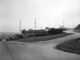
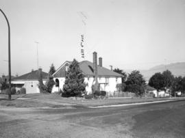
Puget Drive and Eddington Avenue - southeast corner - view southeast
Part of City of Vancouver fonds
Photograph shows 4662 Puget Drive
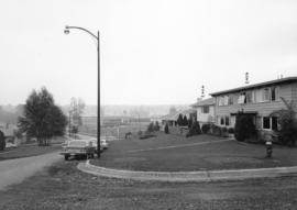
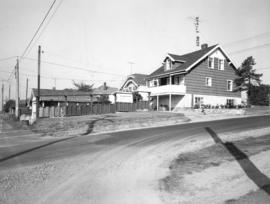
Eddington Drive, south side, from Paton Street to Haggarts Street
Part of City of Vancouver fonds
Photograph shows 2404 and 2406 Eddington Drive

Haggart Street, east side, from 32nd Avenue to lane north - view south
Part of City of Vancouver fonds
Slocan Street, west side 3rd to 4th Avenues - viwe northwest
Part of City of Vancouver fonds
Photograph shows 2699 and 2687 East 4th Avenue
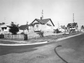
Slocan Street, west side, between 5th Avenue and lane south - view west
Part of City of Vancouver fonds
Photograph shows the rear of 2698 East 5th Avenue
Slocan Street, west side, 5th to 6th Avenues - view northwest
Part of City of Vancouver fonds
Photograph shows 2697 East 6th Avenue and the rear of 2698 East 5th Avenue
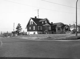
Slocan Street, west side, 5th to 6th Avenues - view southwest
Part of City of Vancouver fonds
Photograph shows 2698 and 2694 East 5th Avenue and a part of 2697 East 6th Avenue
![Abbott and Cordova [Streets looking] north](/uploads/r/null/8/a/8aab879fc7571cea390137d122ac3a89381071b678502757448c72f1fa930e4f/7cda2f7c-4836-4e9a-bb47-04f727a330f0-A42710_142.jpg)
Abbott and Cordova [Streets looking] north
Part of City of Vancouver fonds
![Abbott and Cordova [streets looking] east](/uploads/r/null/7/0/707fb0b0f3ba16b327f9d40a0a0a94b3f918509e20ac40ab413928d75ff1b6a8/c28af97b-ce7e-4953-b6ff-6e0979093ac1-A42711_142.jpg)
Abbott and Cordova [streets looking] east
Part of City of Vancouver fonds
Photograph shows Sissons Sporting Goods
![Abbott and Hastings [streets looking] north](/uploads/r/null/5/8/58a47efab97572b4c13cd6b981dd3dac02110898a57c7c528946196e79ba9346/863bf6d2-596f-499c-868a-28abd249fb85-A42714_142.jpg)
Abbott and Hastings [streets looking] north
Part of City of Vancouver fonds
Photograph shows Woodwards
![Alder [Street] and 6th [Avenue looking] west](/uploads/r/null/9/c/9c3510984925b6c73b0f03fe9efc1a5f0c4f319bc1012d03aa9caa3e5b60cb47/373b8340-f09c-4f8c-b47d-a21aa18ae822-A42723_142.jpg)
Alder [Street] and 6th [Avenue looking] west
Part of City of Vancouver fonds
![Alma [Street]and Broadway [looking] south](/uploads/r/null/4/d/4dafffe711c2871a06198b0ffd371738a92f41b9a756e865cf32b41bb712a733/f1a34532-ad4a-4a7f-a67d-e800c9132525-A42726_142.jpg)
Alma [Street]and Broadway [looking] south
Part of City of Vancouver fonds
![Alma [Street] and Broadway [looking] north](/uploads/r/null/f/e/fe19941ed63249d77fd1b5a19cf8c68f6469fc9a1fa766c7170f69506850e2d1/d27e2826-b62d-4fd1-aac2-de85149a4ae5-A42728_142.jpg)
Alma [Street] and Broadway [looking] north
Part of City of Vancouver fonds
![Alma [Street] and 4th [Avenue looking] north](/uploads/r/null/a/5/a50d988adfd3b22b6c365431eb3726d4e3eb73628b853daab3b875bb3f6700a3/ff9d2cba-84bd-435b-92bd-deabeb9c49d6-A42730_142.jpg)
Alma [Street] and 4th [Avenue looking] north
Part of City of Vancouver fonds
![Alma [Street]and 4th [Avenue looking] east](/uploads/r/null/e/5/e557f27514af8857453a9450046f1b30553547a00b35628a894961af8d88a665/f807e8e4-5d51-48c1-b66f-50b484316e80-A42733_142.jpg)
Alma [Street]and 4th [Avenue looking] east
Part of City of Vancouver fonds
Photograph shows the Bank of Montreal
![Arbutus [Street]and Broadway [looking] north](/uploads/r/null/a/1/a16cc4ef006e6e28cc208698987666eed3d0b7aa65b9d2ccc4db998f090051a5/4f4ce6b5-20c2-4919-9d07-39f8ca56bb0a-A42739_142.jpg)
Arbutus [Street]and Broadway [looking] north
Part of City of Vancouver fonds
![Arbutus [Street] and King Edward [Avenue looking] north](/uploads/r/null/e/e/eedd7a27efc2a3e6245f77ceb05e94c3d66c3366f759c6e2471b7dd3e616903b/5ba54149-f063-4833-b589-df9aa2e19817-A42743_142.jpg)
Arbutus [Street] and King Edward [Avenue looking] north
Part of City of Vancouver fonds
![Arbutus [Street] and 4th. [Avenue looking] west](/uploads/r/null/7/d/7d9f8911c9b2f39be150dd2f41aa148975ee8505d71eb7b33b3d06e8cb78fb3c/6693c0e5-ce2b-429b-82c7-7a7da91d4e8d-A42748_142.jpg)
Arbutus [Street] and 4th. [Avenue looking] west
Part of City of Vancouver fonds
Photograph shows Slumber Magic and the Magic Flute
![Arbutus [Street] and 16th [Avenue looking ] west](/uploads/r/null/a/e/aeb97257a10068f02ec787f62a21f86fd3afe8d406b0103c682723a9d9e82842/97b177ee-9ce0-48ec-92b4-c1d675f5deb2-A42755_142.jpg)
Arbutus [Street] and 16th [Avenue looking ] west
Part of City of Vancouver fonds
![Balsam [Street] and 4th [Avenue looking] east](/uploads/r/null/9/b/9b5239b50423d2fba88da3a74f8d3e06c7bb37682914703bf42d5ce5c4a87608/dabe0c31-af9f-4c95-9557-4354af850590-A42765_142.jpg)
Balsam [Street] and 4th [Avenue looking] east
Part of City of Vancouver fonds
![Balsam [Street] and 4th [Avenue looking] west](/uploads/r/null/6/f/6fa41a1a955cf9ef742c29788264365bc80f4c9f1c7669c652777473271a2ae1/fe03600e-a251-458a-bdc7-a7272c1149a5-A42768_142.jpg)
Balsam [Street] and 4th [Avenue looking] west
Part of City of Vancouver fonds
![Beach [Avenue] and Thurlow [Street looking] west](/uploads/r/null/2/3/23c699fc5040859c8da92714096b3ea3af61c33e29c1ae655d96ab19b0b4eb89/82cd55d9-0956-49f0-acbf-8170963e11f6-A42770_142.jpg)
Beach [Avenue] and Thurlow [Street looking] west
Part of City of Vancouver fonds
![Beach [Avenue] and Thurlow [Street looking] north](/uploads/r/null/c/4/c4ad54a5b1008db5b8f49947db08d3ed99da796a97f6ee690edaded85cb72df5/70fa2f82-7a1b-4822-898f-7dc3ca465434-A42771_142.jpg)
Beach [Avenue] and Thurlow [Street looking] north
Part of City of Vancouver fonds
![Beatty and Dunsmuir [Streets looking] west](/uploads/r/null/a/5/a5cc70fc63b687b855560327354898a98485aa1722ce5ed472b0f5e04ddb980d/5f3cede3-6490-40ec-b097-77b4de2855bc-A42774_142.jpg)
Beatty and Dunsmuir [Streets looking] west
Part of City of Vancouver fonds
Photograph shows the Sun Tower in the background
![Beatty and Georgia [streets looking] north](/uploads/r/null/3/1/31215f49fea2b0a3182e4a22b043fa56460d30315d5b5a37cd5c1a18f7900c25/1d47aeac-0b19-4088-ab9d-705c282128c7-A42779_142.jpg)
Beatty and Georgia [streets looking] north
Part of City of Vancouver fonds
Photograph shows the Sun Tower in the background
![Beatty and Georgia [streets looking] east](/uploads/r/null/3/3/33944f96c671fc89227f3ce50aa069ab0576754f612c01887c66f18bc8a83b47/079b60c9-73aa-493b-8e23-6cf9ab35432e-A42780_142.jpg)
Beatty and Georgia [streets looking] east
Part of City of Vancouver fonds
Photograph shows the entrance to the Georgia Viaduct
![Beatty and Pender [streets looking] south](/uploads/r/null/2/5/2531b5210db68527a5ccee955968194b513a9d96cb5b28e7ff4f1c60fafca3a3/dbe31229-ecc3-423b-b107-4948607c7ea6-A42783_142.jpg)
Beatty and Pender [streets looking] south
Part of City of Vancouver fonds
![Beatty and Robson [streets looking] east](/uploads/r/null/2/c/2c163d3ab49dc2469f3b79215bfa7d1a6d2efb116f4043a54549fd47b393da8d/b87bf5c7-60dc-4daf-8e7e-9fb886af6fdc-A42785_142.jpg)
Beatty and Robson [streets looking] east
Part of City of Vancouver fonds
Photograph shows a part of BC Place Stadium
![Blanca [Street] and 16th [Avenue looking] east](/uploads/r/null/9/3/93caa1fa1dbdcc6293861d9bac7485adb7596f38eb8edce68d41ffcb5937483d/d30ed246-94bb-45dc-89db-3904b7bb785f-A42799_142.jpg)
Blanca [Street] and 16th [Avenue looking] east
Part of City of Vancouver fonds
![Blanca [Street] and 16th [Avenue looking] west](/uploads/r/null/0/2/02c3a98ff392286c45413fd4ce2dc31690eeaed89526d71533d4e7d3380af17e/fdf4a195-2760-44ae-af0b-cb2d40ce7fa4-A42800_142.jpg)
Blanca [Street] and 16th [Avenue looking] west
Part of City of Vancouver fonds
![Blanca [Street] and 16th [Avenue looking] southwest](/uploads/r/null/4/9/49feaf49efbe64d9d2981320065c0d36d1429c12756e561ca6cfc73776dcae10/a74d960b-4603-4b5c-8aa9-cc4e82401d1b-A42801_142.jpg)
Blanca [Street] and 16th [Avenue looking] southwest
Part of City of Vancouver fonds
![Blenheim [Street] and Broadway [looking] west](/uploads/r/null/0/5/058522f37ed76c0598558abe9176c5c160f20104e4054fc23c94f17ac3c9f4e8/1ca7bcf1-8dd9-4cd0-872e-343553c91dfe-A42804_142.jpg)
Blenheim [Street] and Broadway [looking] west
Part of City of Vancouver fonds