![[A irrigation slough on Langley Prairie]](/uploads/r/null/f/4/f4e653c6ff0b8baabb986c4ce1df4b76e971d96113a8e949cbc280eda21777e7/17ecd7b6-b27d-41b6-b3cc-ab6c76b3052d-A75974_142.jpg)
[A irrigation slough on Langley Prairie]
- AM640-S1-: CVA 260-823
- Item
- [ca. 1938]
Part of James Crookall fonds
172 results directly related Exclude narrower terms
[A irrigation slough on Langley Prairie]
Part of James Crookall fonds
Additives in city water supplies

Cadastral map of upper Seymour Creek
Part of City of Vancouver fonds

Capilano and Seymour water sheds
Part of City of Vancouver fonds
Item is a map which includes topography and waterworks infrastructure such as pipelines, tunnels, intakes, proposed reservoirs, etc.
![[Capilano Creek waterworks]](/uploads/r/null/7/7/77575f1809735b16a9944f412163f98f596dd55ac925f50b13267002dfa3ffb8/232096c5-a1aa-4f89-8724-7825d09e71e0-A25800_142.jpg)
Part of Major Matthews collection

Part of James Crookall fonds
![[Capilano intake under construction]](/uploads/r/null/6/f/6f6b6a1f00b9e8c7fbe2e24b56bde6aa84fa0cf07075b0761255ba8c45f7dac6/d0e64ccf-c7c1-4b54-90a8-61e85d653480-A25755_142.jpg)
[Capilano intake under construction]
Part of Major Matthews collection
![[Capilano intake under construction]](/uploads/r/null/f/b/fbdc1de0c3c565d6bb6d73ecb7fa7c905ebcfb72761d59616fff4332297e59af/39b97459-fa98-40e8-9f9a-3e2725b3209f-A25754_142.jpg)
[Capilano intake under construction]
Part of Major Matthews collection
![[Capilano Waterworks intake building]](/uploads/r/null/2/f/2f461bfdbf1b1144074d96f4031a976ef02110fb57def61b851eb0372ca22d31/9fdf0314-5407-4c9d-b60c-9996dba20a98-A33149_142.jpg)
[Capilano Waterworks intake building]
Part of Major Matthews collection
Photograph shows 'The Lions' peaks in the background
![[Capilano Waterworks intake building]](/uploads/r/null/7/6/76e4c454effcd9bb7c2a7f6190364ca500e3ffcdc2fce2011272dafaddc8fb4a/8d4cc7d0-f415-4e45-91a9-8671b6a8428b-A33153_142.jpg)
[Capilano Waterworks intake building]
Part of Major Matthews collection
Photograph shows 'The Lions' peaks in the background
![[Capilano Waterworks intake building]](/uploads/r/null/5/f/5f6de108fcac4d8c99c41f03a35d2283a27aea5dda8b2ec96a80c249beac3b08/6ec016cb-d7eb-409d-9d6b-4a311cf496fa-A33154_142.jpg)
[Capilano Waterworks intake building]
Part of Major Matthews collection
Photograph shows 'The Lions' peaks in the background
![Capilano Waterworks [intake under construction]](/uploads/r/null/1/d/1d4f172ef9396d7561840b4082c9ea8a8ac509302235976823831c77e4b80b19/f7b4b561-94b2-49de-b018-b832b0fed05b-A25772_142.jpg)
Capilano Waterworks [intake under construction]
Part of Major Matthews collection
Men identified; Steve Madision, H.M. Burwell and Henry L.Lewis
![Capilano waterworks System [laying pipes]](/uploads/r/null/9/4/949ccf2e51ae1fab90340f9da83a795027039aa833089600e953fd3df75652f5/a45bf37a-f81c-4847-9e68-1c73f3f21ce8-A25757_142.jpg)
Capilano waterworks System [laying pipes]
Part of Major Matthews collection
![Capilano Waterworks System [laying pipes]](/uploads/r/null/e/0/e09bcb9816e84525696fe9d1125b212b3d1f6ef0cff08c8e5460411aa12c6532/64e0a45f-d44d-49c5-90ab-8d22108dd1d2-A25758_142.jpg)
Capilano Waterworks System [laying pipes]
Part of Major Matthews collection
![Capilano Waterworks System [laying pipes]](/uploads/r/null/c/a/ca4cc22a1c6107314e820c135f5dda0ecb225f5a0e72021d80718c402e7deb45/7274c27f-c2c9-41f8-a9bb-a45fcd276647-A25759_142.jpg)
Capilano Waterworks System [laying pipes]
Part of Major Matthews collection
![[Chlorinating machinery at the Capilano Waterworks]](/uploads/r/null/a/0/a06dad600c2ca9cf6ddbf590c6c06d7dc8d4fb0582d5ca044e1cdaeabc8d2818/7844e03e-0a0a-4d5e-87aa-fb8e8654578a-A33150_142.jpg)
[Chlorinating machinery at the Capilano Waterworks]
Part of Major Matthews collection
![[Chlorinating machinery at the Capilano Waterworks intake]](/uploads/r/null/e/e/eeb677474e51cb233f118688f314c1f1a6b9d6df29ff14bf928d105716f93054/51c66387-8af0-4080-b167-3b4bf60f56ba-A33152_142.jpg)
[Chlorinating machinery at the Capilano Waterworks intake]
Part of Major Matthews collection
Part of Major Matthews collection
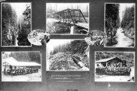
Photograph shows eight images of Seymour Creek canyon and bridge, pipes under construction, and guests at the opening and luncheon

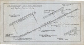
City of Vancouver Waterworks Department. Profile of Capilano and Seymour Creek water mains
Part of Major Matthews collection
Photograph negative is a copy of an annotated plan showing the path of the water mains.
Coquitlam Water Works Co'y : [water distribution plan]
Article is a photocopy of an excerpt from magazine Vol. 61, No. 13, dated April 1, 1909. H.M. Burwell was an engineer with the Vancouver firm, Hermon and Burwell, Engineers.
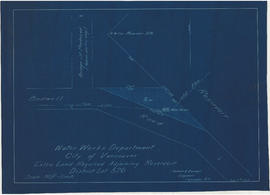
Extra land required adjoining reservoir. District Lot 526
Part of City of Vancouver fonds
![[Filtration equipment at the Capilano Waterworks intake]](/uploads/r/null/a/4/a4475eda66575951f6640bcef13563c916a99f23c5abbe4540ce5b95fd58ceb6/0562904a-92fc-4c2b-ab26-08aa5ff0f083-A33151_142.jpg)
[Filtration equipment at the Capilano Waterworks intake]
Part of Major Matthews collection
![Final location of pipe line through [District] Lot 791](/uploads/r/null/3/3/8/338c70bb04cabd4bcf8223c485229014009e6984d8002c854e4d5ff6d11b634e/336af1c6-ee08-4bc2-8f4b-373f2a289a69-LEG1153_142.jpg)
Final location of pipe line through [District] Lot 791
Part of City of Vancouver fonds
Fire Department, Vancouver, Nov. 1889
![[First dam on Capilano River]](/uploads/r/null/2/c/2c18611b7daf0e3d42499f11a298f2cf939cbb5a0fbc6271038b81e5c8af6a15/468a4292-241a-4b94-bb5d-e5a8aa363662-A25748_142.jpg)
Part of Major Matthews collection
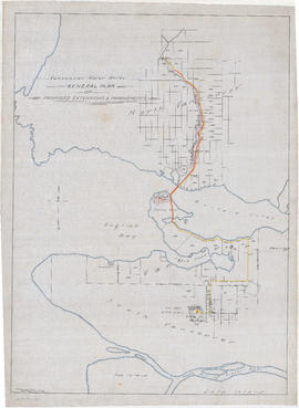
General plan of proposed extension & improvements
Part of City of Vancouver fonds
Item is a map which depicts existing and proposed new waterworks infrastructure, including the proposed new Little Mountain reservoir.
How Vancouver gets snow-water from mountain streams
Item is excerpt from British Columbia Magazine, dated June 1911.
![Irrigation system [for] potato patch](/uploads/r/null/9/6/96cb515ddf72506de339e5a963ae30844380f2e4e05968f54c06f3d538224f6f/a0404b73-3eb9-40ae-992b-18bce392da51-A14519_142.jpg)
Irrigation system [for] potato patch
![Irrigation system [for] potato patch](/uploads/r/null/f/8/f80e4fd822407fdb9da076dbeb2bfec9c5482002e5f168b4565b2ac388842f99/daa01ace-6612-4cea-9af6-23049da0765b-A14517_142.jpg)
Irrigation system [for] potato patch
Note on negative envelope "Near Chilliwack / Indian memorial / Stallo Indian burial"
![Irrigation system [for] potato patch](/uploads/r/null/a/2/a2402fbfe6153bcea18f8b0d70589eda396e3a8775e1b4806f81a6d01f6aea53/bade4cfa-b0fe-4eb6-b589-8e719cba9a16-A14518_142.jpg)
Irrigation system [for] potato patch
![[L.D. Taylor and Water Commissioner at Seymour Falls]](/uploads/r/null/2/5/251bba39f97d31e2e8736c2bb5a9a2b9a93a0d55071f22a89eee1e422a625d7f/93022752-ba99-4dc7-8199-bb9d4af4d952-A72978_142.jpg)
[L.D. Taylor and Water Commissioner at Seymour Falls]
Part of L.D. Taylor family fonds
L.D. Taylor is the man on the left.
![[L.D. Taylor at Seymour Falls]](/uploads/r/null/0/d/0df9c16521d47497f10b5f462658a8acf6b17a3bc24687c85ce303b9513a839e/38af8b7d-b6db-42d2-9c1b-04caaafe14d9-A72977_142.jpg)
[L.D. Taylor at Seymour Falls]
Part of L.D. Taylor family fonds
![[L.D. Taylor at Seymour Falls]](/uploads/r/null/e/3/e3c24b13a3184d9677b42b8a5dff08f9a0f5c5bba350023fe36e63798a76c2d9/fb5a7bdc-54ac-4426-805f-92b9c4ea242f-A72976_142.jpg)
[L.D. Taylor at Seymour Falls]
Part of L.D. Taylor family fonds

Part of City of Vancouver fonds
Item consists of an architectural drawing sheet containing two drawings, titled: Typical section through embankment, and Plan.
Little Mountain reservoir lining
Part of City of Vancouver fonds
Item consists of an architectural drawings sheet containing detail drawings.

Little Mountain reservoir. Proposed submerged fountain to be placed in centre of reservoir
Part of City of Vancouver fonds
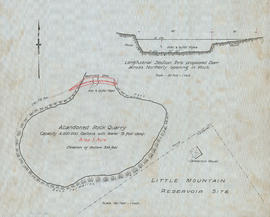
Little Mountain reservoir site
Part of City of Vancouver fonds
![[Log wall to prevent erosion into Capilano intake]](/uploads/r/null/b/3/b3ae8312ced182dacc9ee78673229136a4b97821ab4930bfd15288a34d39d0e1/6d5fba11-da59-42b1-a4db-dcd8df8aeeb6-A25750_142.jpg)
[Log wall to prevent erosion into Capilano intake]
Part of Major Matthews collection

Lower Mainland Regional Plan : water supply
Part of Community Planning Association of Canada, British Columbia Division fonds

Part of Yaletown Productions Inc. fonds
Film produced for for the Ministry of Tourism and Small Business Development by New Horizons Films.
![[Man standing in a ditch south of Marine Drive]](/uploads/r/null/6/9/69e5c28f95ae291de523d4354de2fcebdebf0726dbf2f1eb744ae1dece7aa252/45b0aab5-469e-4066-b037-5d0e90812424-A19340_142.jpg)
[Man standing in a ditch south of Marine Drive]
Part of Major Matthews collection
![[Man standing in ditch where pipes are being laid through fields south of Marine Drive]](/uploads/r/null/a/6/a67c79d76024ba86718cde483b190c3abaf0445f966d126057fe9d9a475f8e18/4c9e7fad-b854-44e6-abe0-427b45be0679-A19337_142.jpg)
[Man standing in ditch where pipes are being laid through fields south of Marine Drive]
Part of Major Matthews collection
Map of City of Vancouver and vicinity
Part of City of Vancouver Archives technical and cartographic drawing collection
Item is a map showing Vancouver, Richmond, Burnaby, Coquitlam, Surrey, Pitt Meadows, North Vancouver and West Vancouver and parts of Maple Ridge and Langley. The Capilano River and Seymour Creek catchment area and Coquitlam conservation reserve are shown.

Map of Greater Vancouver Water District
Part of City of Vancouver Archives technical and cartographic drawing collection
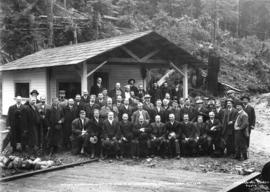
Mayor, Aldermen and Guests at Opening of Waterworks Seymour Creek
Part of Major Matthews collection
Group portrait showing Mayor Bethume, T.F. McGuigan, W. Hepburn, J.W. Prescott, J.H. Calland, Colonel McSpadden, H.M. Burwell, Colonel F.W. Boultbee, Dr. Underhill, A.J. Pilkington, Sam Robb and others
![[New Capilano Intake]](/uploads/r/null/7/c/7cf80b3160de35f8649ff6e50fbdf718a85b7b53e4923e961067dac30a16c431/cc37fc37-a22f-4701-872d-75d9acb5bdfb-A25784_142.jpg)
Part of Major Matthews collection
Panoramic view
![[New Capilano Intake]](/uploads/r/null/8/6/862d8a37fa41cce8cf3f6212d0b16ad0faf66de4e3de124774d706a2a8337bc5/97230bc7-d025-40d8-a82a-1d2dd28770a9-A25778_142.jpg)
Part of Major Matthews collection
![[New Capilano Intake]](/uploads/r/null/b/f/bf9f64c601b9e8ba2ca290a88335a25d764776a5cd423b134daa8dac5e2c45f4/60507e6c-b8f6-495e-bb7c-e9769b85b347-A25781_142.jpg)
Part of Major Matthews collection