
In Mount Rainier Park : Some of the Corduroy Road on the way to Rainier Park
- AM427-S4-F2-: CVA 289-002.304
- Item
- [between July 3 and July 9, 1922]
Part of William Orson Banfield fonds
12 results directly related Exclude narrower terms
In Mount Rainier Park : Some of the Corduroy Road on the way to Rainier Park
Part of William Orson Banfield fonds
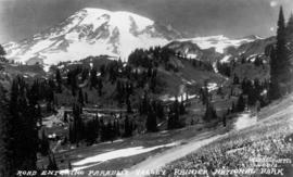
In Mount Rainier Park : The road entering Paradise Valley
Part of William Orson Banfield fonds

In Mount Rainier Park : The road to Paradise Inn, winding up the hill side
Part of William Orson Banfield fonds

Part of William Orson Banfield fonds

Part of William Orson Banfield fonds

Part of William Orson Banfield fonds

Part of City of Vancouver Archives technical and cartographic drawing collection
Map shows present and proposed roads of the Lower Mainland and northern Washington State, as well as road repairs. Map covers the area from Point Grey to Hope and from Burrard Inlet to Bellingham Bay. Trails and roads indicated on the map include Telegraph Trail, Waggon Road and Pitt River Waggon Road, as well as several unnamed trails. Major bodies of water indicated on the map are Burrard Inlet, False Creek, Burnaby Lake, Pitt River, Fraser River, Sumas Lake, Sumas River, Chulukweyuk River, Harrison River, Boundary Bay, Semiahmoo Bay and Bellingham Bay. Place names are indicated throughout the map. 11T3 Roads & Trails is printed on the side of the map.
![The road at summit [of] Blewet Pass](/uploads/r/null/8/7/a/87af9a01f91e6a639af597d399c2e04b941e6bb36f49e35531f96a2c196a342f/6eb5986e-f3e3-4be3-8663-3b8cfd485586-CVA289-004_142.jpg)
The road at summit [of] Blewet Pass
Part of William Orson Banfield fonds
![View on the Chuckanut Drive, Pacific Hiway [Highway]](/uploads/r/null/0/a/1/0a1f1953636564ca1646814e64cd543aec5e12b70d12d5ead5e12114ec2165d1/feb53896-e5dd-42a0-855f-c0967c781f64-CVA289-003_142.jpg)
View on the Chuckanut Drive, Pacific Hiway [Highway]
Part of William Orson Banfield fonds
![View on the Chuckanut Drive, Pacific Hiway [Highway]](/uploads/r/null/b/6/0/b6025b13309e21bdb54af6e223a16ae7ab6bf53a3d09a2def09a8c93166d0ea5/dd783a7b-beab-4ff7-bad9-301024b32a21-CVA289-003_142.jpg)
View on the Chuckanut Drive, Pacific Hiway [Highway]
Part of William Orson Banfield fonds
![View on the Chuckanut Drive, Pacific Hiway [Highway]](/uploads/r/null/4/d/0/4d058fcb9f0d5b32ed97fd9c5af0e35e8283cc8b152eafdd34d5578209db5363/41e49344-b986-472a-9e9e-408f242cb37d-CVA289-003_142.jpg)
View on the Chuckanut Drive, Pacific Hiway [Highway]
Part of William Orson Banfield fonds
![View on the Chuckanut Drive, Pacific Hiway [Highway]](/uploads/r/null/8/a/1/8a1138124e805230ee4e02a2286badfe44ff977e5a46f86409a07f8161f7aa71/cd291a91-4ce1-4e1f-8aeb-db5917ba39b1-CVA289-003_142.jpg)
View on the Chuckanut Drive, Pacific Hiway [Highway]
Part of William Orson Banfield fonds