![[The entrance to Fairhaven Park]](/uploads/r/null/d/1/d1bce377719fe72a83156fee9aea583aace0164cc961d110e6a8551a35571d1a/9c2c756b-94f8-4b17-9397-2c86e0a87287-A26812_142.jpg)
[The entrance to Fairhaven Park]
- AM54-S4-: Out P64
- Item
- [ca. 1940]
Part of Major Matthews collection
133 results directly related Exclude narrower terms
[The entrance to Fairhaven Park]
Part of Major Matthews collection
![[View of Mount Shuksan from the road to Mount Baker]](/uploads/r/null/d/7/d77b6396eecb2d0f09fe1df0a14704f25d6a92df9eb23bf1fc9adae7a87adaa0/b0cecf3c-95b9-48e0-81cf-a5524cdb66dc-A32833_142.jpg)
[View of Mount Shuksan from the road to Mount Baker]
Part of Major Matthews collection
![[Lake Terrell in Whatcom County]](/uploads/r/null/2/2/2223e2313d4eb14277ea1f4ce3a6deab7ce88c988a6a741e894d461b467c2d2b/1e783d26-377f-4cfa-9940-0c8a79154760-A33354_142.jpg)
[Lake Terrell in Whatcom County]
Part of Major Matthews collection
![[Lake Terrell in Whatcom County]](/uploads/r/null/f/e/fe72f9dbaa7426884cb9ce7f067de3d81742514a33fa456f973f887839188f26/df077ebb-9776-4b4b-9711-8883a251c90a-A33355_142.jpg)
[Lake Terrell in Whatcom County]
Part of Major Matthews collection

Part of Major Matthews collection


Landscape - general : basalt columns (central Washington)

Landscape - general : Mt. Rainier

Wildlife : Hurricane Ridge, olympic marmot

Wildlife : Hurricane Ridge, olympic marmot

Wildlife : Hurricane Ridge, Olympic Marmot

Wildlife : Blue Grouse Hurricane Ridge
![Leutkea pectinata [at] Mount Baker, Washington](/uploads/r/null/a/5/a5f8a6e5bb8edbdef585415bc1740855a77d3fd59747a072826ea4a478102eb2/f50f9cfa-8de1-4116-aa45-09f812c82a5f-A56376_142.jpg)
Leutkea pectinata [at] Mount Baker, Washington
![Orthocarpus imbricatus : owl's clover [at] Hurricane Ridge](/uploads/r/null/2/3/23d6ad2373cdf9b28420acef1c262e781de9e62098aa8ac5edc6160421f07ce5/21890175-83db-46ce-83f3-bdc27c9a7246-A56773_142.jpg)
Orthocarpus imbricatus : owl's clover [at] Hurricane Ridge
![Paeonia suffruticosa [at] US Nat[ional] Arboretum](/uploads/r/null/3/6/3606ad94689fed4f1740c5d2c87ba8439a9e306af33a0c6504995c8199f0bcb9/fc80ad8b-5e31-4462-b96b-2eafc2bc0f2f-A57154_142.jpg)
Paeonia suffruticosa [at] US Nat[ional] Arboretum

![Phyllodoce empetriformis, Hurricane Ridge - Olympic Pen[insula]](/uploads/r/null/e/2/e2214854c50ece5526d274af6b748ec02f81df8f96d535fc5831ecd0e298f7ce/c231e151-61e8-4dfb-b2e4-4f15c426fce0-A57201_142.jpg)
Phyllodoce empetriformis, Hurricane Ridge - Olympic Pen[insula]
![Vaccinium [at] Mount Baker, Washington](/uploads/r/null/3/3/338e12c80bcf0050cb72f9fee4dcc07a6d63e1e11fe4ae1e46a591e9f9700888/539c7e4f-1a83-4682-930e-c61019972a0b-A58319_142.jpg)
Vaccinium [at] Mount Baker, Washington
![Veratrum [at] Mount Baker, Washington](/uploads/r/null/8/0/80c95d684d66b84d35f9ff795d098fae90d542e9efd215455c701df685169c6d/051712fc-6b92-478a-a2e6-ece0f2ecf2ba-A58334_142.jpg)
Veratrum [at] Mount Baker, Washington
![Veratrum [at] Mount Baker, Washington](/uploads/r/null/9/c/9c38d8792e2c86902dfa539e3525cd77be414e011c9d1cb0f371b8c9955f3f75/086b1136-c8a9-4d27-abb1-601c25f41ce1-A58335_142.jpg)
Veratrum [at] Mount Baker, Washington
The nature of borders : salmon, boundaries, and bandits on the Salish Sea
Item contains a commercial and visitors map of the southwestern land districts of British Columbia on one side and textual information on the region on the other.

Southwestern districts : Map no. 1K : comparative geographical study
Part contains information on the southwestern districts of British Columbia, including population, climate, agriculture, industry, labour, and education; itineraries for exploring the various regions; information on Canadian customs regulations and game regulations; and diagrams of road routes to British Columbia from California and Alberta/western Washington.
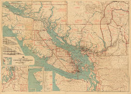
Part contains a commercial and visitors map of the southwestern land districts of British Columbia, encompassing Vancouver Island and the mainland from Seymour Inlet in the northwest to Black Pines in the northeast, extending south to Chiwaukum, Washington. Primary map shows settlements, government agent offices, mining and sub-mining recording offices, game reserves, customs posts, hospitals, ferries, campsites, golf courses, canneries, commercial air harbours, lighthouses, radio stations, motor boat refill stations, power sites, railways, roadways, trails, telegraph and telephone lines, steamship routes, topographic contour lines, and locations of falls and rapids. Text on the map provides information on land features and the presence of wild and farmed animals, and indicates current and possbile agricultural and industrial land use. Inset maps show the northern tip of Vancouver Island, Triangle Island and West and East Haycock Islands, and northwestern Washington State from Seattle to Centralia. A key map shows the location of the area covered by the main map in relation to the rest of North America.

South western British Columbia
Item is a map of southwestern British Columbia and northwestern Washington showing cities, municipalities, and settlements, post offices, government agents, railways, roads, ferry and steamship routes, air and seaplane ports, parks, campsites, glaciers, customs ports of entry, and elevations of mountains. Inset maps show the islands north of Cape Scott and the Seattle region. An small key map shows the primary map's location in relation to the rest of British Columbia and other maps published in the same series.


Part of City of Vancouver Archives technical and cartographic drawing collection
Item is a map showing the Pacific Coast of British Columbia and Washington and Oregon states as surveyed by French explorer Jean-Francois de Galaup (Laperouse) in 1786, and the routes of his ships Astrolabe and Boussole. The map shows the Pacific coastline from Cap Rond (Tillamook Head) in Oregon at latitude 45 degrees and 40 minutes in the south to Baeie de Clonard (Beresford Bay, northwestern tip of Haida Gwaii) in British Columbia at latitude 54 degrees and 10 minutes in the north. Other major place names on the map include Nootka, Pointe Boisee, Baie St. Louis, Iles de Sartine, Mont Fleurieu, Cap Fleurieu, Cap Hector, Mont de la Touche, Baie de la Touche, and Baie de Clonard. Vancouver Island is shown as part of the mainland. Map includes latitudes and longtitudes as well as indication of elevations. Map is a plate from the "Atlas de Voyage de la Perouse".
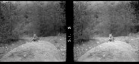
![1 Deer Longmire [Mt. Rainier]](/uploads/r/null/e/1/e/e1e7d6400146bab4f0d33a3cb9f820d2773cf4077aa9c9ae8554ec55c862da5b/e7f6864f-9503-4421-a797-1be455ffe931-CVA260-2077_142.jpg)
Part of James Crookall fonds
Item is a stereograph
![2 Deer Longmire [Mt. Rainier]](/uploads/r/null/5/2/3/523908f1e38ee7cb8afbbf7146607455413eb367b90b3b9b2154c3c04686c134/fbd86f4e-9609-40c5-90fb-f0b4722639ee-CVA260-2078_142.jpg)
Part of James Crookall fonds
![3 Deer Longmire [Mt. Rainier]](/uploads/r/null/e/b/5/eb595bf79f053445a135185ea1e8ef9e7894f90fabe4f6336318e58acd70d110/468e38ad-1a73-44f0-b973-8770dafb1071-CVA260-2079_142.jpg)
Part of James Crookall fonds
![Mount Rainier from Longmire [?] [Range]](/uploads/r/null/1/0/8/1088d5ac0afeb217f147026186082922f02b572ad58ea5f2a9de567e4c7c76be/02b3caf3-7359-4f5c-97b1-fc7c4fea9cf7-CVA260-2080_142.jpg)
Mount Rainier from Longmire [?] [Range]
Part of James Crookall fonds
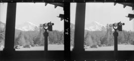
Mount Rainier from Longmire (telescope)
Part of James Crookall fonds
![Mount Rainer across from [Rim] at Longmire [bridge in photo]](/uploads/r/null/6/1/b/61b2f62a0ce21b38f293d3758843df208ea12fc67b064ab6973c20ed6abc283a/31880743-04b2-4cc9-a3b2-c6153baf5c38-CVA260-2082_142.jpg)
Mount Rainer across from [Rim] at Longmire [bridge in photo]
Part of James Crookall fonds
![Mount Rainier across from [Rim] at Longmire (through trees)](/uploads/r/null/e/4/7/e47758ea80dc2818f05595a08e28fde1e9c0c4ea0c5c87418d653b07d23431aa/2a69ab14-3ea2-4956-ae56-83d5f2c82bf3-CVA260-2083_142.jpg)
Mount Rainier across from [Rim] at Longmire (through trees)
Part of James Crookall fonds
Part of James Crookall fonds

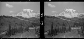
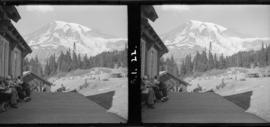
Mount Rainier from Ricksecker Point
Part of James Crookall fonds

View towards Longmire, Ricksecker Point
Part of James Crookall fonds
![Narada Falls [Mt. Rainier]](/uploads/r/null/b/7/a/b7a75a964b21a52015369b4b03528d136a704030a66c9ea4259be97bfcd557be/64fdb4a2-9802-4cdb-b36d-8b2c4febcea2-CVA260-2087_142.jpg)
Part of James Crookall fonds

Part of James Crookall fonds
Part of James Crookall fonds

Part of James Crookall fonds

Part of James Crookall fonds

Part of James Crookall fonds

Part of James Crookall fonds

Part of James Crookall fonds
![1 Tatoosh Range (wildflowers) [Mt. Rainier]](/uploads/r/null/3/0/0/300425f8623c7a4d232ec27f5e2c11854a06a7c1a768adc09ade9c8c1ea90600/d77104fb-b6fd-4971-8f29-0a94dec86165-CVA260-2095_142.jpg)
1 Tatoosh Range (wildflowers) [Mt. Rainier]
Part of James Crookall fonds
![2 Tatoosh Range (wildflowers) [Mt. Rainier]](/uploads/r/null/e/d/0/ed00d272a1147a16e1cd05759072d6ae2f66e6ea45c10a9cf6c1c6b48791b488/e4859104-5f36-4753-8136-804efd7a1f2d-CVA260-2096_142.jpg)
2 Tatoosh Range (wildflowers) [Mt. Rainier]
Part of James Crookall fonds

Part of James Crookall fonds
Tatoosh Range from lodge verandah
Part of James Crookall fonds
Part of City of Vancouver Archives technical and cartographic drawing collection
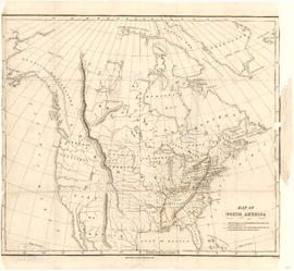
Item is a map showing "Mr. Stuart's route through the United States, and Canada in 1828, 29 & 30" and "the boundary of the United States, both on the side of the British Possessions, & those in Mexico." The northern border of United States territory west of the Rocky Mountains is incorrectly noted at 54/40, to reflect American claims of the time.