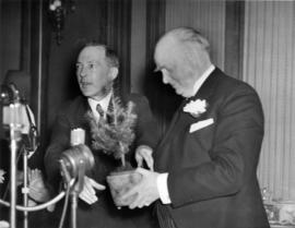
R.B. Bennett presented with small Douglas Fir by Jim McVety at luncheon
- AM1616-S1-: CVA 136-359
- Item
- Jan. 9, 1939
Part of Pacific Press fonds
73330 results directly related Exclude narrower terms
R.B. Bennett presented with small Douglas Fir by Jim McVety at luncheon
Part of Pacific Press fonds
E.A. Earle residence [1302 Matthews Street]
Part of Ross A. Lort, Architect fonds
Address: Vancouver - Matthews Street, 1302
Section through wall : residence for E.A. Earle, Esq., Shaughnessy Heights
Part of Ross A. Lort, Architect fonds
Address: Vancouver - Matthews Street, 1302
Roof and attic plan : residence for E.A. Earle, Esq., Shaughnessy Heights
Part of Ross A. Lort, Architect fonds
Address: Vancouver - Matthews Street, 1302
North and south elevations : residence for E.A. Earle, Esq., Shaughnessy Heights
Part of Ross A. Lort, Architect fonds
Address: Vancouver - Matthews Street, 1302
Interior details : residence for E.A. Earle, Esq., Shaughnessy Heights
Part of Ross A. Lort, Architect fonds
Address: Vancouver - Matthews Street, 1302
Ground floor plan : residence for E.A. Earle, Esq., Shaughnessy Heights
Part of Ross A. Lort, Architect fonds
Address: Vancouver - Matthews Street, 1302
Ground and second floor plans : residence for E.A. Earle, Esq., Shaughnessy Heights
Part of Ross A. Lort, Architect fonds
Address: Vancouver - Matthews Street, 1302
First floor plan : residence for E.A. Earle, Esq., Shaughnessy Heights
Part of Ross A. Lort, Architect fonds
Address: Vancouver - Matthews Street, 1302
Elevations : residence for E.A. Earle, Esq., Shaughnessy Heights
Part of Ross A. Lort, Architect fonds
Address: Vancouver - Matthews Street, 1302
East and west elevations : residence for E.A. Earle, Esq., Shaughnessy Heights
Part of Ross A. Lort, Architect fonds
Address: Vancouver - Matthews Street, 1302
Basement plan : residence for E.A. Earle, Esq., Shaughnessy Heights
Part of Ross A. Lort, Architect fonds
Address: Vancouver - Matthews Street, 1302
Basement and second floor plans : residence for E.A. Earle, Esq., Shaughnessy Heights
Part of Ross A. Lort, Architect fonds
Address: Vancouver - Matthews Street, 1302

Item is a photograph showing performers and some audience members on the lawn of the former home of F. Ronald Graham at 6101 NW Marine, now known as Graham House belonging to Green College, UBC.

Sheet G : Trafalgar Street to Granville Street and Sixteenth Avenue to Nanton Avenue
Part of City of Vancouver Archives technical and cartographic drawing collection
Item is a section showing the area from Trafalgar Street to Granville Street and Sixteenth Avenue to Nanton Avenue. Includes streets and roads; blocks, lots and legal descriptions; and parks, schools, railway lines and golf courses.
Vancouver (B.C.). Office of the City Engineer
![Cast in Play at Columbian College of Arts [B.C. College of Arts?]](/uploads/r/null/6/c/6c640d40659a266b353ab8965759ef05b1d6938d8c8a3760b056d795dbc9bb3a/702ec5d6-8df4-483b-9b82-bddeed56e811-A18681_142.jpg)
Cast in Play at Columbian College of Arts [B.C. College of Arts?]
Part of Stuart Thomson fonds
Group portrait

Part of Pacific Press fonds
The Marine Building, Vancouver, B.C.
Part of Robin Ward fonds
Based on line copy negative 99-8-123.
The Marine Building, Vancouver, B.C.
Part of Robin Ward fonds
File includes three artist's proofs of engraving. See also 99-08.209.1 to 99-08.209.3 for the limited edition prints.
File consists of eighteen photographs of a ceremony for those Vancouverites that turned twenty-one in 1936 and had been honoured as part of the Golden Jubilee festivities. The first part of the ceremony took place at St. Andrew's Wesley Church followed by a tea and Dance at Hotel Vancouver. Individuals identified are Mayor Michael Harcourt, Dal Richards and Mart Kenney.
Chevron Stage at Park Party Tours 1986
File consists of twenty photographs of Party Party Tour activities.

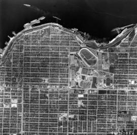
Aerial photo, vertical, False Creek, Fairview to Kits Point
Item is a photograph of False Creek, showing English Bay to W 16th Avenue, and from Maple Street to the Cambie Street Bridge. Includes the Burrard Street Bridge, the new Granville Bridge, the Cambie Bridge, and Granville Island.

Aerial photo, vertical, University of British Columbia and University Endowment Lands

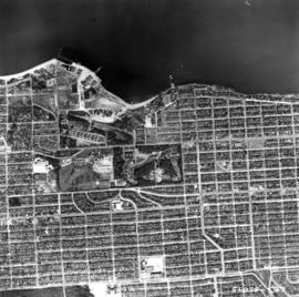
Aerial photo, vertical, Little Mountain and Oakridge and surrounding area
Item is a photograph of Little Mountain and Oakridge, showing from W 30th Avenue to W 54th Avenue, and from Hudson Street to Main Street. Includes the Langara golf course and Queen Elizabeth Park.

Aerial photo, oblique, downtown Vancouver to North Shore Mountains
Item is a photograph of the Vancouver area looking northwest over downtown Vancouver including the Hotel Vancouver, Provincial Courts, the Marine Building, Stanley Park, Burrard Inlet, Lion's Gate Bridge, and Coal Harbour.
![Florrie, Stan, Colin and Joanne (10 months) [at the beach]](/uploads/r/null/e/c/6/ec622868be01fbb31d7a68ad0fc3455fe874b02115cd22b21a5cf0b8eeaa6400/a9687721-e5af-4e39-a361-1149aba85e2a-CVA217-013_142.jpg)
Florrie, Stan, Colin and Joanne (10 months) [at the beach]
Part of Robert W. Jackson fonds
Item is a photograph showing family members of R.W. Jackson at the beach.
Part of Eleanore Jane Rittenhouse fonds
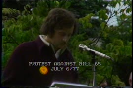
Item is a Channel 10 documentary about the Vancouver Resources Board (VRB) and Bill 65, which would abolish the VRB. The intention of the program is to save the VRB. David Schrek, regional manager of the VRB, describes the board's services, as well as tho

Aerial view of Little Mountain area
Item is an aerial photograph showing an oblique view of the Little Mountain area.
![Vancouver looking east from [Howe Sound]](/uploads/r/null/6/6/66fa4a6e8bb1ab5d20d8f951fa93ad57dd828be645aff6d182d88a8b36c69281/69bee6e1-54a6-4c8f-a7db-043e03b4dfe6-A23503_142.jpg)
Vancouver looking east from [Howe Sound]
Part of Major Matthews collection
Oblique view. Photograph shows Point Grey, University of British Columbia and University Endowment Lands.
Typewritten letter from Hunting Survey Corporation Limited on verso of print.
![[Aerial view looking north over] Granville Island](/uploads/r/null/8/3/83f9be0a597100103c181fa4d68c68baa4a0802471126afafea3b7850103e12b/ea9e7fb6-7465-4fa6-8fa9-18923e3d9307-A49646_142.jpg)
[Aerial view looking north over] Granville Island
Oblique view showing the Granville Bridge and the new Granville Bridge under construction, the Kitsilano Trestle Bridge, of the Burrard Bridge and the industrial and undeveloped areas on the north and south sides of False Creek

Aerial photo, oblique, 41st Ave. and Oak St., Vancouver
Item is a photograph from Oak and 41st Ave, looking north, with a large partially cleared green area at the bottom of the frame, with downtown, Stanley Park, and the North Shore Mountains in the upper frame.
Aerial photo, vertical, Exhibition Park and surrounding area
Item is a photograph of Exhibition Park and the surrounding area, looking north. The area photographed runs from Vancouver Harbour to Charles Street, and from Lakewood Drive to Skeena Street.

Aerial photo, vertical, Marpole and junction of Fraser River, Bridgeport
Item is a photograph of Marpole and northern Richmond, looking north. The area photographed centres on the fork of the Fraser River at Sea Island, and runs from W 67th Avenue to Cambie Rd., and from the western most tip of Richmond Island to the west tip of Mitchell Island. Includes the Marpole Bridge and both Oak Street and Moray bridges under construction.

Aerial photo, vertical, Deadman's Island, Coal Harbour and surrounding area
Item is a photograph of Deadman's Island, including Coal Harbour, and the southwest part of Stanley Park. Compass north is the left side of the photo.

Aerial photo, oblique, CPR docks in foreground, looking south Granville Street at centre
Item is a photograph of the Vancouver waterfront, looking southwest down Burrard Street, showing the waterfront and downtown Vancouver, including Waterfront Station, Hotel Vancouver, Marine Building, Burrard Bridge, Granville Street Bridge, and the city beyond.
Aerial photo, vertical, Jericho Beach Park and Kitsilano
Item is a photograph of Jericho Beach Park and the surrounding area, looking north. The area photographed runs from English Bay and Jericho Beach to W 16th Avenue,and from Sasamat Street to Balaclava Street.

Aerial photo, vertical, Iona Island and Fraser River
Item is a photograph of Iona Island. The area photographed includes the northwest corner of Sea Island and the southwest corner of Southlands. Rafts of lumber are visible.
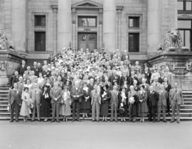
U.C.T. Convention Group on Courthouse Steps
Part of Stuart Thomson fonds
Group portrait
![[B.C.E.R. car (number 26) "Robson St.-Park" with passengers]](/uploads/r/null/9/f/9fb294cb0cde1fec2878c116a23fe066fad683cbe5ddb4d65b51b727c1df7ee6/1418f98c-797f-4333-8f15-1f14bd628f7e-A60807_142.jpg)
[B.C.E.R. car (number 26) "Robson St.-Park" with passengers]
Part of Major Matthews collection
![[B.C.E.R. car (number 25) loaded with passengers]](/uploads/r/null/6/a/6a612bd44b382e02fac2c560e00dcf66438779e6c7c98dbf357b38eedb649591/c7fa6af8-a712-4291-80f8-9e2c088efd14-A60806_142.jpg)
[B.C.E.R. car (number 25) loaded with passengers]
Part of Major Matthews collection
![[View of the reception held for the Duke of Connaught in the court house grounds]](/uploads/r/null/3/a/3a70c04ab2ea4ddf26867d9283ceaff2bda2e2d8adeede604dd8bc95a79af8bd/87e2f7b0-4d41-4f38-ba2c-d57265c9743d-A26031_142.jpg)
[View of the reception held for the Duke of Connaught in the court house grounds]
Part of Major Matthews collection

Part of Major Matthews collection
Photograph shows barges under construction and the B.C. Cement Co. plant in the background. Men identified: Joseph McDonald, Henry R. McDonald and Mr. W.W. Burrough

Part of Major Matthews collection

Part of Major Matthews collection
Photograph was exhibit 8 in the Ducharme murder case

[A.W. Lundell, William Manson and Mayor W. Hardman on the platform at the launch of "The Canadian"]
Part of H.A. Price collection

Part of City of Vancouver fonds
Part is a section depicting the area bounded by Boundary Road to Triumph Street to Slocan Street to Charles Street. The sheet has been extensively annotated, with colour coded areas to depict land use, status of lots as tax sale properties for sale, sewer and water lines, as well as other colour codes that are not noted on the legend at the front of the volume.

Vancouver section 3 supplementary information
Part of City of Vancouver fonds
Part is a sheet showing information noted about assessments and other information relevant to Vancouver section 3.

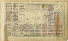
Part of City of Vancouver fonds
Part is a section depicting the area bounded by Boundary Road to Charles Street to Slocan Street to Seventh Avenue. The sheet has been extensively annotated, with colour coded areas to depict land use, status of lots as tax sale properties for sale, sewer and water lines, as well as other colour codes that are not noted on the legend at the front of the volume.
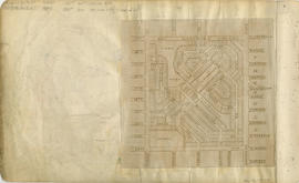
Vancouver section 4 supplementary information
Part of City of Vancouver fonds
Part is a sheet showing information noted about assessments and other information relevant to Vancouver section 4. The sheet also includes a small map of the redevelopment of the are bounded by Boundary Road to 13th Avenue to Rupert Street to 22nd Avenue.
Part of City of Vancouver fonds
Part is a section depicting the area bounded by Boundary Road to Seventh Avenue to Slocan Street to Seventeenth Avenue.