- COV-S505-2-: CVA 772-20
- Item
- [July 1965]
Part of City of Vancouver fonds
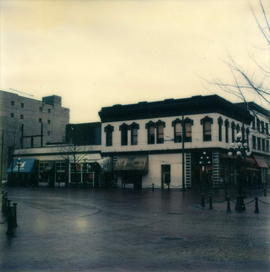
Photograph shows south side of the 8oo Block of Hastings Street as viewed from the north west including Buckshon's Pharmacy, Dean's Grocery, the Hastings Auditorium and the Rice Block (404 Hawks Avenue).
![[800 E Hastings St]](/uploads/r/null/2/8/28ac1de86a0ec4e02f2ccaebd198f03b30e9d50715bfcf7843b57a82d6981417/14007932-5aa0-49f6-9caa-c7bb2c95c70a-A43722_142.jpg)


![A business street [looking along Hastings west from Columbia Street]](/uploads/r/null/a/8/a8d6e79a0a0d65f71f57bf92f2c6f04024dcf145384c4c3557b9f4e3e9381790/f8519b55-0564-460d-8173-64ad01d879ad-A18126_142.jpg)
![[A Labour Day parade travelling east on Cordova Street at Cambie Street]](/uploads/r/null/d/7/d7b839f4fbe203aabdb4921ac11840f35ebae16fe14f7975578240ed429c970e/d14b1508-8b07-493c-b887-cf9c4607e046-A37250_142.jpg)
![[A parade celebrating VJ Day on Pender Street]](/uploads/r/null/d/2/c/d2c624cbb295abd99dfcbce8c9a1d74acfe126849e3a820934416699ae942dfe/f70c97f4-1855-4fbd-9fae-db43dc0444e9-CVA260-1412_142.jpg)
![[A parade celebrating VJ Day on Pender Street]](/uploads/r/null/6/9/5/6950ec243113934ac6ba2b533ebb6ee37a932787e8bfdc1ce53afe22fc60297d/e0189c62-fd54-4b9a-9b3b-cb2487f6373b-CVA260-1413_142.jpg)


![Abbott and Cordova [streets looking] east](/uploads/r/null/7/0/707fb0b0f3ba16b327f9d40a0a0a94b3f918509e20ac40ab413928d75ff1b6a8/c28af97b-ce7e-4953-b6ff-6e0979093ac1-A42711_142.jpg)
![Abbott and Cordova [Streets looking] north](/uploads/r/null/8/a/8aab879fc7571cea390137d122ac3a89381071b678502757448c72f1fa930e4f/7cda2f7c-4836-4e9a-bb47-04f727a330f0-A42710_142.jpg)
![Abbott and Cordova [streets looking] south](/uploads/r/null/a/0/a0cc0b3fae386948c1f612a73d1afc769e9f21ad0ef7f95f4b605d28d77fb481/dc3a8637-54ed-41fe-800d-6963f3874e48-A42712_142.jpg)
![Abbott and Cordova [streets looking] west](/uploads/r/null/9/e/9e6ecc370bc289e5be80f2c7024a559ad55f83ec49ec64c8f3a8df89481637f7/f7d058c6-cc09-4ac7-85bf-be6f0d56c87c-A42713_142.jpg)
![Abbott and Hastings [streets looking] east](/uploads/r/null/f/a/fa0d67515affc3ab9a0a5625d6d6d6e103e07a6f1a5d936f025bfd1d86416738/bf20e84f-2d2c-4ba3-a778-dfd77978f715-A42715_142.jpg)
![Abbott and Hastings [streets looking] north](/uploads/r/null/5/8/58a47efab97572b4c13cd6b981dd3dac02110898a57c7c528946196e79ba9346/863bf6d2-596f-499c-868a-28abd249fb85-A42714_142.jpg)
![Abbott and Hastings [streets looking] south](/uploads/r/null/b/5/b544e518553624021781cfa66497db9d4e5415be7a853308220ff20ba0e55d04/e36cff59-bee3-43fc-9f5b-9676823d57cb-A42716_142.jpg)
![Abbott and Hastings [streets looking] west](/uploads/r/null/1/a/1a3c9bdca5e9a05a681433abe9fe739bf52e86440936b967e1a49e5ea06628b0/99dd753a-1f99-4729-89d6-21b755a5eeb1-A42717_142.jpg)
![Abbott and Pender [streets looking ] north](/uploads/r/null/9/d/9de039d396f0787f98a3c11fec214560dcbdca0c3cb771177d7cb6ca0391d578/aa90253c-1c9b-4ba2-8fd9-853e20de1ed9-A42718_142.jpg)
![Abbott and Pender [streets looking] east](/uploads/r/null/f/8/f83eaf09fec1ebf23e21a3db3691921915705e4f383ef44a5027be0102269396/3566daa7-37b0-43c3-96e2-f30d512ad817-A42719_142.jpg)
![Abbott and Pender [streets looking] south](/uploads/r/null/b/b/bb5e90c611916f1b8ac5bbd1c7756bb79e72acbd41bf494dd418f633f3c49dca/284f1b6d-4e1e-4720-966f-571e057fc42c-A42720_142.jpg)
![Abbott and Pender [streets looking] west](/uploads/r/null/3/8/381a5e24e6f31f4ff4aeb1880be8c4287b3e02db633e38ff65d5b4e404cdf5df/78ddcacf-45a1-41c4-b724-6f0f4dfaa8cf-A42721_142.jpg)


![[Aerial view of Downtown Vancouver and False Creek]](/uploads/r/null/0/8/087fe83a1eefc33a2d459ff334b7d0e0a538373b4cd81c1bdcfd7fe9e133d279/a723e464-4fab-4bb6-bee2-27d542364fb0-A58788_142.jpg)
![[Aerial view of Mount Pleasant, South Strathcona and Kensington-Cedar Cottage]](/uploads/r/null/7/5/75ea991fe8319eaffda79b314cbf20e281e35eb2cd8a89eaa898b492242d6282/05f856f3-0a45-41eb-94dc-46cb9d2f7ecf-A63348_142.jpg)
![[Aerial view of the Westcoast Building construction site - 1333 West Georgia Street]](/uploads/r/null/1/c/1c5d95b307eee5602334b62cdcaaa9e2eda7f003c6ab9a85b820c19afedf5020/dee85954-684c-49db-87c1-5e4418e03233-A25262_142.jpg)

![Alder and 6th. [Avenue looking] north](/uploads/r/null/b/5/b5e8014aa997d96e6cbf92700ea83aa8dc54d72042b05322e9852ba8ceff9488/44a9a5d1-bf83-4a5b-81ab-2a25d3fa29eb-A42722_142.jpg)
![Alder [Street] and 6th [Avenue looking] east](/uploads/r/null/7/0/70ef5fb6e78a76cbc632a0f3bda72c98e665c83812b2c92f6258996c0e129161/a0b08dbe-f70d-4c8d-b132-e890d6ed422e-A42725_142.jpg)
![Alder [Street] and 6th [Avenue looking] south](/uploads/r/null/a/e/ae393bfbc80a207f68cd15f0f0b40ecc6636b45191de8f943d48ac6dfb55edf6/a8b1130e-2354-4236-8727-50a9e570eb1b-A42724_142.jpg)
![Alder [Street] and 6th [Avenue looking] west](/uploads/r/null/9/c/9c3510984925b6c73b0f03fe9efc1a5f0c4f319bc1012d03aa9caa3e5b60cb47/373b8340-f09c-4f8c-b47d-a21aa18ae822-A42723_142.jpg)


![Alma and Broadway [streets looking] west](/uploads/r/null/a/9/a9d0cd86c9e2a3a08f0cf9012d938c83502308964762978c60185e0b116529b1/2a82edd8-f35f-449c-af6b-5fb00f3617de-A42729_142.jpg)
![Alma [Street] and 10th [Avenue looking] east](/uploads/r/null/e/1/e12c6f44a8883c4526138d85e17fa4bb843d16cb5c4ae9586a8756fa2e45c1d9/29cf56db-6235-430b-9202-29f035f4bebc-A42736_142.jpg)
![Alma [Street] and 10th [Avenue looking] north](/uploads/r/null/3/1/31fdc0b45ca5dae277759a069e22375144a8786e7ce6d5bbfedea4fd98bdc819/7b666127-73fd-4a57-bb6d-891781b616f6-A42737_142.jpg)
![Alma [Street] and 10th [Avenue looking] west](/uploads/r/null/7/2/729767ffc743aae68d7449a142af8e013bfb9769ddaefe2ee870ed2d5c59473f/5b16c857-df94-415a-8f10-1b8b771079bb-A42734_142.jpg)
![Alma [Street] and 4th [Avenue looking] north](/uploads/r/null/a/5/a50d988adfd3b22b6c365431eb3726d4e3eb73628b853daab3b875bb3f6700a3/ff9d2cba-84bd-435b-92bd-deabeb9c49d6-A42730_142.jpg)
![Alma [Street] and Broadway [looking] north](/uploads/r/null/f/e/fe19941ed63249d77fd1b5a19cf8c68f6469fc9a1fa766c7170f69506850e2d1/d27e2826-b62d-4fd1-aac2-de85149a4ae5-A42728_142.jpg)
![Alma [Street]and 10th [Avenue looking] south](/uploads/r/null/0/b/0b6cc14993822a1359e30898ebaa33f0ca8c978e83cecc36be3f36dd0249c628/03b2b3a0-fa9f-448e-b3e3-b465bb91da82-A42735_142.jpg)
![Alma [Street]and 4th [Avenue looking] east](/uploads/r/null/e/5/e557f27514af8857453a9450046f1b30553547a00b35628a894961af8d88a665/f807e8e4-5d51-48c1-b66f-50b484316e80-A42733_142.jpg)
![Alma [Street]and 4th [Avenue looking] south](/uploads/r/null/c/f/cf7e9a9067011e78ebd3dc3dc7d96d0d129def2e617f8aa5225df26f0ec57171/98af76bd-e545-4201-82f8-b628206a453d-A42732_142.jpg)
![Alma [Street]and 4th [Avenue looking] west](/uploads/r/null/2/4/241f65ac07a3303812f88cf461253c395be661bc852ae1569fd330d7a0e288f3/2d8186e9-1973-4367-962b-5bcf6527e5d3-A42731_142.jpg)
![Alma [Street]and Broadway [looking] east](/uploads/r/null/a/f/afd0dff1de21eae47f3b74fc927c36b4de2199db612635f05b427be03980332c/786e1118-45c9-4bea-8ef1-6a645e4399fe-A42727_142.jpg)
![Alma [Street]and Broadway [looking] south](/uploads/r/null/4/d/4dafffe711c2871a06198b0ffd371738a92f41b9a756e865cf32b41bb712a733/f1a34532-ad4a-4a7f-a67d-e800c9132525-A42726_142.jpg)