
Habitat : Tejon Pass - U.S.A. Coreopsis SP
- AM1502-S1-2-: CVA 1502-1460
- Item
- Apr. [19]73
233 results directly related Exclude narrower terms
Habitat : Tejon Pass - U.S.A. Coreopsis SP

Habitat : Yucca Brevifolia Joshua Tree Mojave

Hayden Planetarium, New York - American Indian star myths

Hayden Planetarium, New York - Copernican Room showing Solar System
![[Head and shoulders portrait of Eva Cooley?]](/uploads/r/null/c/0/b/c0b67eef5f2c201716145a42560a59395c971bf7fbcc72c78c07b1e87e52abe2/c7795839-1161-4a58-8dab-8abc7675d972-CVA1477-410_142.jpg)
[Head and shoulders portrait of Eva Cooley?]
Part of L.D. Taylor family fonds
![[Head and shoulders portrait of Kathryn Baker]](/uploads/r/null/3/d/3d49b0425f6b5c99c31c0fa87c826ab3da58956a762ce51effbccc314602ca7f/7f444c8b-3add-4218-abf6-2ab73c0d1f47-A49714_142.jpg)
[Head and shoulders portrait of Kathryn Baker]
Part of L.D. Taylor family fonds
Photograph is inscribed "To 'Uncle' 'Louie' with 'love' 'Kathryn'

Hudson River from Riverside Drive, New York.
This postcard includes personal correspondence. Sent to Miss Hilda Baggs of Bath, England.

Idria columnaris : boojum tree
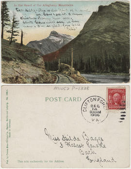
In the heart of the Alleghany Mountains
Item is a postcard. It is addressed to Miss Hilda Baggs of Bath, England.
Interesting Hollywood California
This postcard is addressed to P. Baggs of Vancouver, Canada. Images include: Hollywood and Vine, Hollywood; Hollywood, California, North Hollywood and San Fernando Valley in Distance; Vine Street from Sunset; Columbia Square, Home of KNX Columbia Broadcasting System, Hollywood; Hollywood Boulevard at Night; Earl Carroll Theatre-Restaurant; Hollywood Bowl; Grauman's Chinese Theatre, Hollywood; The Glittering Lights of Hollywood, at Hollywood and Vine; Cahuenga Freeway, Gateway to Hollywood; Planetarium, Griffith Park; The Palladium and Columbia Square; A Portion of "The Floor of Fame", Grauman's Chinese Theatre; Dining in the West patio. The Original Farmer's Market; NBC Radio City, Sunset and Vine, Holllywood; The Rendezvous of the Stars, The Brown Derby; New $3,000,000 Mutual Don Lee Television-Radio Studio; A Glimpse of a Portion of the Business Section.
![[James Crookall and another member of the Royal Flying Corps watching a turtle]](/uploads/r/null/e/1/6/e16c3a571ac1171348f51da0b10aaff152f8565ef138a7906f733250f1933bba/0612a5f4-43c5-4f62-a661-40a8d08103d2-CVA260-1984_142.jpg)
[James Crookall and another member of the Royal Flying Corps watching a turtle]
Part of James Crookall fonds
![[James Crookall and another member of the Royal Flying Corps watching a turtle]](/uploads/r/null/4/a/d/4adb46e81e8d93918618348337d548c235899388a3d7692e5ab4184e164994a2/4fa56f9a-b690-4acd-ab84-dcd14c7037ae-CVA260-1872_142.jpg)
[James Crookall and another member of the Royal Flying Corps watching a turtle]
Part of James Crookall fonds
![James Crookall in 79 [airplane] at Cresson](/uploads/r/null/4/2/9/4293430d5777cc88710064c94f967ce588c7e9c494e531c436993f0c92134a59/196e5727-f34f-404f-acb0-9ccf260a3aba-CVA260-1738_142.jpg)
James Crookall in 79 [airplane] at Cresson
Part of James Crookall fonds
![James Crookall writing letter [at] Cresson](/uploads/r/null/8/d/e/8defa99b581e7f84be2c274fbc0e1985fb6a27e3a928556c7b31e802525e6382/01d6fd46-c420-4257-bdd2-700d86b0cbe3-CVA260-1752_142.jpg)
James Crookall writing letter [at] Cresson
Part of James Crookall fonds

Part of L.D. Taylor family fonds

Katherine Baker marries Paul Yull
Part of L.D. Taylor family fonds
Inscription on verso of photograph lists, from left to right: "Arthur [Baker?], Paul [Yull], Katherine [Baker Yull], Mamma, Papa, Myself - Edith [Baker]"
![[Ken Taylor]](/uploads/r/null/8/d/8d30a03269f219c26a36db90348c8a54e5c138b607a82fd24f39ce0bb4e38cfc/dfae5ba6-1f85-4120-9dbe-a9a7c453063b-CVA1477-893_142.jpg)
Part of L.D. Taylor family fonds
Head and shoulders portrait.
![[Ken Taylor smoking a pipe in his military uniform]](/uploads/r/null/7/7/7716980a0bd0388536a159394c55174f9868ef08e81421f55e933d75716a5e0e/aa9957a9-6397-4e42-956b-5fcefbd703b0-CVA1477-894_142.jpg)
[Ken Taylor smoking a pipe in his military uniform]
Part of L.D. Taylor family fonds
![Ken [Taylor standing outside]](/uploads/r/null/5/f/5fa0d202a722fe0bcb1fd0238e1ed5ba4cec1d59a2a51c539da1e32cec0cac2c/7b84ac7f-f16b-437b-8842-9fdc8918b57e-CVA1477-596_142.jpg)
Part of L.D. Taylor family fonds

This postcard includes personal correspondence. Sent to Mrs. A.J. Harrison of Vancouver, B.C.

Locations - General : Providence Canyon Georgia

Lower New York from an aeroplane
This postcard includes personal correspondence. Sent to Mr. and Mrs. A.J. Harrison of Vancouver, B.C.

This postcard includes personal correspondence. Sent to Mrs. J. Harrison of Montreal.
![[Man and boy in horse drawn carriage in Plainfield, New Jersey]](/uploads/r/null/d/0/d03c59668072720dc7be07c623eebbd5abd6b74f00ddb803cc457f7126df571f/ba3f0ee7-e557-41dd-beb7-7847f8478f2b-A50910_142.jpg)
[Man and boy in horse drawn carriage in Plainfield, New Jersey]
Part of L.D. Taylor family fonds
![[Man and woman in horse drawn carriage in Plainfield, New Jersey]](/uploads/r/null/e/b/ebd9b7ae5fcc8b2256480120ddb8ccf72881e56046f5b76e9e9b9833aff41ea6/25213b6b-ee1e-4ab1-a89a-4df43ece202f-A50912_142.jpg)
[Man and woman in horse drawn carriage in Plainfield, New Jersey]
Part of L.D. Taylor family fonds
![[Man sitting in the forest]](/uploads/r/null/5/0/5022fec4e386eeca6a9e3a5f1512656a31d1d32901d53525eddc68ffdcd5c71a/1e9388cf-eeb3-4215-aa0b-f64d70fae9e5-CVA1477-551_142.jpg)
Part of L.D. Taylor family fonds
![[Man sitting on horse]](/uploads/r/null/3/9/3986fc7f6463219507bd9e8674ad0f498d941fa089f77dc2fad4de0127db62c6/8976e79b-7af3-45d0-81af-0650eb6d8395-A50914_142.jpg)
Part of L.D. Taylor family fonds

Map of the United States and territories together with Canada etc.
Part of City of Vancouver Archives technical and cartographic drawing collection
Item is a map showing the boundaries of U.S. territories and states and the southern portion of Canadian colonies of Vancouver Island, British Columbia, Canada East, Canada West, as well as New Brunswick, Prince Edward Island and Nova Scotia. The map also shows cities and principal geographical features. Two inset maps show "Hampton Roads and Norfolk Harbour" and "Pensacola Bay" in greater detail.
![[Mary Louise Taylor at the beach]](/uploads/r/null/4/3/4324a1ce029c9cf943d4e0a3d02bd0bc8feeddd39b814734ad0dd033731f1425/54b14f10-a194-41b0-9e38-c42f3096c9de-CVA1477-1280_142.jpg)
[Mary Louise Taylor at the beach]
Part of L.D. Taylor family fonds
![Mary Louise Taylor [outside with dog]](/uploads/r/null/3/8/382c3bf8b45e59fb2921bcf71a2fbb34c3663ed4465abe7e0bdc5044464f7170/47a43f65-56ae-4fdf-b64a-81c021ce1484-CVA1477-595_142.jpg)
Mary Louise Taylor [outside with dog]
Part of L.D. Taylor family fonds
![[Mary Louise Taylor playing oudoors]](/uploads/r/null/2/1/218322c7f022ec40f85f2cd1f74345f6e3e127e4ff2ca0dd2af3a5d0f9b85b9f/c4d7984a-7422-4d09-a30f-e23c8121e94e-CVA1477-1251_142.jpg)
[Mary Louise Taylor playing oudoors]
Part of L.D. Taylor family fonds
![[Mary Louise Taylor playing oudoors]](/uploads/r/null/5/a/5af24948468ec0134d09368a9e27f2454348160a36fd01072b3b9b74672ddeb1/cf9b3fc7-b376-43c1-918d-630030ba2967-CVA1477-1252_142.jpg)
[Mary Louise Taylor playing oudoors]
Part of L.D. Taylor family fonds
![[Mary Louise Taylor sitting in chair outdoors]](/uploads/r/null/1/7/172ff6a7c4573a6cd4c244b6de0636599629697153aa58c9ea253b8007092f6a/01284e6c-37b9-412e-b0fc-ad2bf552469e-CVA1477-1248_142.jpg)
[Mary Louise Taylor sitting in chair outdoors]
Part of L.D. Taylor family fonds
![[Mary Louise Taylor sitting outside with unknown woman]](/uploads/r/null/6/4/6449fcdc345d9ffa6ef05f4639a96bb5531d2536a45ecea433147cf01fb5f353/2d4c3bdd-43a7-4bd9-9d10-e42614912b00-CVA1477-1253_142.jpg)
[Mary Louise Taylor sitting outside with unknown woman]
Part of L.D. Taylor family fonds
![Mary Louise Taylor [standing outside with dog]](/uploads/r/null/8/6/86abb61f312ea6dbd83bce6cfadb25643985dc58db4b1f5caa53440f71d03f9a/940de045-6c35-419f-b52c-14ec133cbb9b-CVA1477-594_142.jpg)
Mary Louise Taylor [standing outside with dog]
Part of L.D. Taylor family fonds
![[Mary May Beaton]](/uploads/r/null/d/a/da9e88c7a97bbbf7fad13bde1a6dab7edee8e474ec2451e91921e85dcba7870d/8ba6414e-71b4-4fd6-b2be-541870b11606-CVA1477-1027_142.jpg)
Part of L.D. Taylor family fonds
Head and shoulders studio portrait, tentatively identified by Ted Taylor as Mary May Beaton, Octavia Beaton's daughter-in-law.

This postcard includes personal correspondence. Sent to John Hood of Vancouver, B.C.

Mercer School Building, Charleston, W. Va.
This postcard includes personal correspondence. Sent to Miss Baggs of Bath, England.

Moanalua Gardens, Honolulu, T.H.
This postcard includes personal correspondence. Sent to Mr. and Mrs. A.J. Harrison of Vancouver, B.C.

Part of James Crookall fonds
![Mrs. Sloan and her garden and [?] side of 44 Hamilton Avenue](/uploads/r/null/6/b/6ba98c1726039aec2d29ad0fb67abc4ba5146718a1e4d71d51cba79122439a98/c41ed3a0-a707-4d4e-9f76-3472acd9ca64-CVA1477-559_142.jpg)
Mrs. Sloan and her garden and [?] side of 44 Hamilton Avenue
Part of L.D. Taylor family fonds

Mt Baker - Shots of Washington, Mt Baker National Forest Reserve

Mt Shuksan from Kulshan Ridge, Mt Baker National Forest Reserve
![Neomarica gracilis : Apostle Plan [and] Walking Iris [at] Hawaii Trop[ical] Bot[anical] G[arden]](/uploads/r/null/4/7/47fd153f22616e8c78ae6fdbc6a55297cbeea3a49d847430b67997fd17367a6b/f56f9b72-890f-4e5c-bb50-895226472d73-A56719_142.jpg)
Neomarica gracilis : Apostle Plan [and] Walking Iris [at] Hawaii Trop[ical] Bot[anical] G[arden]
![Neomarica gracilis : Walking Iris Apostle Plant [at] Hawaii [Tropical] Bot[anical] G[arden]](/uploads/r/null/7/5/75ecbc9b79f4550453e7c4536cf22abf2dc5178359a4e80f8c56fd94b1cf7b4b/0c7b8791-c144-412d-956b-cf7d86d63d2b-A56720_142.jpg)
Neomarica gracilis : Walking Iris Apostle Plant [at] Hawaii [Tropical] Bot[anical] G[arden]
![[New Haddon Hall, Atlantic City]](/uploads/r/null/3/c/a/3caf65620ceafe149310ada2b05dbcacdedcfe59d122786a47128edb2fecb36d/ec487bef-0d4f-4ea8-b319-a882e7ffcf7d-AM1052P-1318_142.jpg)
[New Haddon Hall, Atlantic City]
This postcard includes personal correspondence. Sent to Mr. and Mrs. A.J. Harrison of Vancouver, B.C.
![[Octavia Beaton and unidentified woman sitting on large stone stairs with dog]](/uploads/r/null/9/7/97b50be7420ec44cd77bea004ea330c704936dc53af0a83abb5336ed2cd68839/4c1f8fba-f085-42e4-be58-7a7ee6a89697-CVA1477-1032_142.jpg)
[Octavia Beaton and unidentified woman sitting on large stone stairs with dog]
Part of L.D. Taylor family fonds

Official highway map of British Columbia, northern Washington, Idaho and Montana
Part of City of Vancouver Archives technical and cartographic drawing collection
Item is a road map designed to be folded into a pamphlet. Primary map shows main roads, secondary roads, roads under construction and highway numbers in the southern half of British Columbia, northern Washington, northern Idaho and northern Montana. Three inset maps show the Trans-Canada Highway, Peace River highways and routes from Prince George to Hazelton. The item also contains information on government ferries, registration of foreign cars, British Columbia provincial parks, Dominion parks, camp fire permits and hours at British Columbia customs stations.
![[Old Denison homestead]](/uploads/r/null/e/f/ef064bc012e923e122bfd3b22d3b3b738e04350528b557e016f8ab77e924d57a/c8a312e9-e97a-48e7-99da-ca574b798ced-A51145_142.jpg)
Part of L.D. Taylor family fonds
![Palo verde cercidium microphyllum, Florence Ar[izona]](/uploads/r/null/5/8/580c76f7049a5ab0532d798cd0569b976812a4de98359382a7b7edb05f9ddd56/0ba076cb-cde5-4a91-b918-696b8d26e5f1-A55215_142.jpg)
Palo verde cercidium microphyllum, Florence Ar[izona]