Diary of significant events in the history of B.C. Electric's Transportaion System, 1889 - 1946.
- HE 311 .C32 V3785 1947a
- [1947]
107 results directly related Exclude narrower terms
Diary of significant events in the history of B.C. Electric's Transportaion System, 1889 - 1946.
Discover Vancouver on transit guidebook
Discover Vancouver transit system

Dunbar and 41st, looking east on 41st
Part of Dunbar History Project fonds
Item filed under Transportation. Courtesy of Hodgson/Sharman Collection.

Dunbar streetcar on Dunbar at 41st Avenue
Part of Dunbar History Project fonds
Item filed under Transportation. Courtesy of Hodgson/Sharman Collection.
Fast trax. The post-secondary student's transit guide, effective September 5, 1988

Focus on Expo - one inch master - Aug. '86
Part of Yaletown Productions Inc. fonds
This item consists of video transfers of film footage shot at Expo 86. The raw footage was transferred to video and edited on tape into a finished production. According to the donor this is the original of the final production with sound and image combined. "Vancouver - Focus on Expo 86" was released August 1986 as a video postcard. Film featuring highlights of Expo 86 . Includes royal visit, highlights of USA, USSR, China, GM, Canada, BC, Folklife pavillions. Director, Michael Collier; Cinematography Bob Asgiersson; Editor Robert Brandreth-Gibbs; Writer Chris Aikenhead; Narration script Chris Aikenhead and Don White; Narrator Jim Hault; Video services Post Haste Video; Film Lab Alpha Cine Services; Sound mix Pinewood Studios; Produced by Yaletown Productions Inc. for Allstar Productions Inc.
Collier, Michael J.
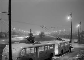
Granville waterfront interchange

Guide map : Vancouver, New Westminster, Burnaby and North Shore municipalities
Part of City of Vancouver Archives technical and cartographic drawing collection
Part contains a map of Greater Vancouver showing city streets, schools, firehalls, parks and golf courses, railways, street railways and interurban lines, hospitals and bus routes.
Guide map. Vancouver-New Westminster. Burnaby and North Shore municipalities
Part of City of Vancouver Archives technical and cartographic drawing collection
Item is a map which shows city streets, local areas, schools, hospitals, firehalls, parks and golf courses as well as railways, street railways and interurbans and bus routes. Street index included on verso. Item includes the original cover attached to the map.
Item is a map and transit guide showing trolley coach lines, bus lines, street car lines, interurban lines, interurban stops, route numbers, B.C. Electric installations and block numbers in West Vancouver, North Vancouver, Vancouver, Burnaby and the University Endowment Lands one one side. The other side consists of three maps showing transit details in Richmond, New Westminster and downtown Vancouver, and descriptive information about B.C. Electric routes and services and Greater Vancouver attractions.

Immigration Building - flower display - Harbour Tower scenery - night view of Vancouver
Part of Harry Lin Chin fonds
Item is a film narrated by Harry Lin Chin in both Chinese and English. Film contains footage showing the demolition of the Immigration Building, magnolia trees, Vancouver Museum and parking lot, Vanier Park, Burrard Street Bridge, views of North Shore and West End from Vanier Park, views of North Shore, Burrard Inlet, Chinatown, and downtown Vancouver from the revolving Harbour Tower restaurant, and scenes aboard the sea bus.

Map and guide of Greater Vancouver
Part of City of Vancouver Archives technical and cartographic drawing collection
Item is a map and guide designed to be folded into a pocket-sized cover. Map shows streets, legal addresses, railway lines, and distances from City Hall. Text includes information on streetcar lines, train and steamship services, postal service, places of worship, office buildings, schools, and theatres.

Map and Guide to Vancouver Street Car and Interurban Lines
Part of City of Vancouver Archives technical and cartographic drawing collection
Part is the front side of an informational pamphlet published by the BC Electric Railway Co. regarding City streetcar routes and interurban lines, golf and country clubs, city trips, interurban trips, motor coach trips, stations, ferries and docks, bathing beaches, public parks, North Shore canyons and parks, athletic and amusement parks.

Map of Burnaby and New Westminster, British Columbia
Part of City of Vancouver Archives technical and cartographic drawing collection
Part consists of a street map of Burnaby and New Westminster, information on bus and street car routes, and text advertising the products and services of the Dominion Map and Blueprint Company.

Map of City of Vancouver, British Columbia
Map shows streets, schools, hospitals, street car lines, railways and address block numbers in Vancouver.

Map of Fraser Valley ; Street map of New Westminster ; Map of Greater Vancouver transit lines
Part consists of a street map of the Lower Mainland and Fraser Valley from Vancouver to Chilliwack, a street map of New Westminster, a map showing transit lines in Greater Vancouver, and text advertising the products and services of the Dominion Map and Blueprint Company.
Map of Vancouver and Lower Mainland : avenue guide
Part of City of Vancouver Archives technical and cartographic drawing collection
Map includes Lower Mainland, B.C. and shows streets, railways, street cars, bus lines, schools, parks and industry.
Map of Vancouver, British Columbia
Part of City of Vancouver Archives technical and cartographic drawing collection
Map shows Vancouver city streets, electric railways, bus lines, city districts and indicates city boundaries with a shaded red line. Concentric circles spaced one mile apart emanate from City Hall's location on the map. A street index is located on the verso.

Mass transit system, the interurbans

O'Brien Advertising : 41st crosstown and Renfrew Heights

O'Brien Advertising : 41st crosstown and Renfrew Heights
O'Brien Advertising : non partisan city shots : housing, sewers etc.

Page from "The Buzzer," November 26, 1937, showing map of bus routes
Part of City of Vancouver Archives technical and cartographic drawing collection
Part is the verso of a hand-drawn map showing bus routes in Vancouver, and contains a page from the November 26, 1937 edition of "The Buzzer." The page contains information on bus routes in Vancouver and a reproduction of the hand-drawn map.

Plan showing bus routes and stops in the downtown area, Vancouver, B.C., October 1961
Part of City of Vancouver Archives technical and cartographic drawing collection
Item is a map showsing bus routes and stops from Burrard Inlet in the north to False Creek in the south and from Main and Terminal in the east to Burrard Street in the west. The map includes a small inset portion showing bus routes and stops immediately south of Granville Bridge.
Sectional map and street directory of Vancouver : Dial map of the city of Vancouver
Part of City of Vancouver Archives technical and cartographic drawing collection
Item is a street map showing Vancouver on one side and Burnaby and New Westminster on the other, as well as information on street car and bus routes, and text advertising the products and services of the Dominion Map and Blueprint Company.
Item is a street map showing Vancouver, Burnaby, New Westminster, West Vancouver, and North Vancouver on one side and Lulu Island and Sea Island, Delta, Surrey, Langley and Maillardville on the other.
Item is a street map showing Vancouver, West Vancouver, North Vancouver and Burnaby on one side and the Lower Mainland from Vancouver to Chilliwack on the other. Item also includes information about bus services in Greater Vancouver and text advertising the products and services of the Dominion Map and Blueprint Company.
Item is a street map showing Vancouver, West Vancouver, North Vancouver, and Burnaby on one side and the Fraser Valley, New Westminster, and Greater Vancouver transit lines on the other. Item also includes text advertising the products and services of the Dominion Map and Blueprint Company.
Part of City of Vancouver Archives technical and cartographic drawing collection
Item is a street map showing Vancouver, Burnaby, New Westminster, West Vancouver and North Vancouver on one side and Delta, Surrey, Langley, Maillardville, Lulu Island and Sea Island on the other.
Item is a street map showing Vancouver, West Vancouver, North Vancouver and Burnaby on one side and the Lower Mainland from Vancouver to Chilliwack on the other. Item also includes information about bus services in Greater Vancouver and text advertising the products and services of the Dominion Map and Blueprint Company.
Skytrain, transportation the world looks up to
The amalgamated association of street, electric railway and motor coach employees of America
The most spectacular 85 cents you'll ever spend
The "people mover" Greater Vancouver needs
The Rational [side A : July 5, 1984]
Part of Co-op Radio fonds
Part contains a recording of The Rational from July 5, 1984 hosted by Patrice Lesley. Topics include a Vancouver transit strike; and the role of labour unions at Expo '86.
The Rational [side B : July 10, 1984]
Part of Co-op Radio fonds
Part contains a recording of The Rational from July 10, 1984 hosted by Gwen Kalio. Topics include poverty levels in Canada, whale deaths due to poisoning, the legal case against Robert Satiacum, and licensing for a free enterprise transit service. Speakers include [Darlene Marzari], a member of Greenpeace and Louise Mandell (Satiacum's Lawyer).

Transit detail inset maps ; Street index ; Transit and tourist information
Part consists of three maps showing transit details in Richmond, New Westminster and downtown Vancouver, and descriptive information about B.C. Electric routes and services and Greater Vancouver attractions.
Transit guide and system map. Shows routes and frequency of service and fares
Transit in British Columbia : the first hundred years.

Transit routes in downtown area Vancouver, B.C. effective July 18, 1952
Part of City of Vancouver Archives technical and cartographic drawing collection
Item is a sheet which contains maps of the downtown portions of 14 BC Electric transit routes: Dunbar, Arbutus, Granville - Kingsway - Victoria, Macdonald, 4th Ave. - West Pt. Grey, Powell - Stanley Park, Broadway East - Robson, Hastings East, Main, Davie - Fraser, Grandview, Oak, Cambie, North Vancouver - Intercity.

Transit system map of Greater Vancouver, B.C.
Part of City of Vancouver Archives technical and cartographic drawing collection
Part contains a map of Greater Vancouver showing bus lines, route numbers, B.C. Electric installations, block numbers, points of interest and amenities; an inset map showing streets in Gleneagles, Whytecliff, and Horseshoe Bay; and an inset map showing streets in Port Moody, Coquitlam, and Maillardville.

Transit system map of Greater Vancouver, B.C.
Part consists of a map showing trolley coach lines, bus lines, street car lines, interurban lines, interurban stops, route numbers, B.C. Electric installations and block numbers in West Vancouver, North Vancouver, Vancouver, Burnaby and the University Endowment Lands.