Topography

Taxonomy

Code

Scope note(s)

Source note(s)

Display note(s)

Hierarchical terms

Topography

Equivalent terms

Topography

Associated terms

Topography

16 Archival description results for Topography

16 results directly related Exclude narrower terms

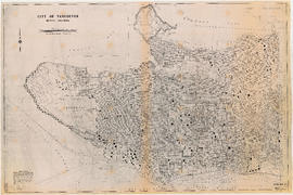
Burrard Inlet : Vancouver sheet : British Columbia

Item is a map showing streets, roads, buildings, trails, railways, electric railways, bridges, swing bridges, foot bridges, churches, schools, post offices, wharves, piers, dikes, piling lighthouses, lightships, beacons, ranges, range lights, buoys, triangulation stations and geographical features in Burrard Inlet from Moodyville in the east to First Narrows in the west. A small index map shows this and other numbered sheets in relation to one another.

Contour plan of a portion of the City of Vancouver

Item is a map of the area from Chilco Street to Raymur Avenue and Coal Harbour/Vancouver Harbour to False Creek showing topographic contour lines, streets, block numbers (in Roman numerals), sewers, manholes, and elevations at various points along streets.

Fraser River Delta, British Columbia

Item is a map of the Fraser River and Lower Mainland showing the following: roads, electric railways and tramways, bridges, churches, schools, post offices, cemeteries, international, municipal, township and city boundaries, wharves, lighthouses, triangulation stations and boundary monuments. Map gives topography of the land and shows water lines, tidal flats and intermittent streams.

Howe Sound - Burrard Inlet

Item is a topographical map of the municipalities surrounding Howe Sound and Burrard Inlet. Municipal boundaries, roads and other transportation infrastructure, and radio stations are also included. The Greater Vancouver water supply areas and waterways are shown along with pipe lines, power lines and telegraph lines.

Howe Sound - Burrard Inlet

Item is a topographic map in two sections showing British Columbia north of Burrard Inlet to Britannia Creek in the north, and from Howe Sound in the west to Indian Arm in the east. Map shows lakes, streams and other natural features; roads, railways, communication lines, cities and other built features; and land, timber, and mineral surveys by number.

New Westminster

Item is a map showing topography, roads, trails, railways, bridges, boundaries, reserves, power lines, telephone lines, triangulation stations, camera stations, bench marks, houses, barns, mills, factories, schools, churches, post offices, telephone exchanges, mines and geographic features in the area of South Burnaby and New Westminster, extending south through Surrey and White Rock to the United States border. A small index map shows the area covered by the primary map in relation to other maps in the series.

Vancouver sheet, British Columbia

Item is a map of Vancouver Island and the southwest portion of mainland British Columbia from Bella Coola to Clinton, and south to New Westminster. Map shows geological, land district, and park boundaries; locations of mining recording offices and sub-offices; elevations in feet above sea level; mineral occurrences; and the development of geological formations by era.

Vancouver, British Columbia

Item is a topographical map showing lands alienated or covered by application under the Land Act, timber leases, native reserves, government reserves, and various boundaries, as well as campsites, picnic sites, forest service lookouts, post offices, settlements, schools, hospitals, mines, dykes, historic monuments, roads, trails, railways, power lines, phone lines, air harbour or seaplane anchorages, etc. Sheet contains an index map showing adjoining maps in the series.