Check list survey of multi-problem families
- AM1519-: PAM 1960-171
- Item
- 1960
316 results directly related Exclude narrower terms
Check list survey of multi-problem families
Lower mainland air quality study, summary report
![Mr. Chas Coburn [Copy of survey map of Zeballos]](/uploads/r/null/9/f/d/9fd592159853676e0317c030c447451cc252f4c835e7616d3215f851a12a5e48/95a518bd-678c-473f-abb2-e66b47c90e95-CVA99-7332_142.jpg)
Mr. Chas Coburn [Copy of survey map of Zeballos]
Part of Stuart Thomson fonds
Fraser River and Burrard Inlet
Part of City of Vancouver Archives technical and cartographic drawing collection
Item is a nautical chart which show details of the area surveyed from Pitt Lake in the north to Roberts Bank in the south and from (what is now) Harrison Hot Springs in the east to Bowen Island in the west. The chart shows soundings in Burrard Inlet, and along the Fraser River.

Part of City of Vancouver Archives technical and cartographic drawing collection
Map shows a survey conducted by the Canadian Pacific Railway of English Bay, Burrard Inlet and Coal Harbour, including a rough outline of area and lots. Note on map reads "Certified as a correct plan showing the land required for right of way Burrard Inlet B.C., February 22, 1886. H.J. Cambie, Engineer in Charge." Map is certified as correct and signed by various C.P.R. officials, including W.C. Van Horne.

North America. West Coast. Fraser River and Burrard Inlet
Part of City of Vancouver Archives technical and cartographic drawing collection
Item is a nautical chart which show details of area surveyed from Pitt Lake in the north to Roberts Bank in the south and from (what is now) Harrison Hot Springs in the east to Bowen Island in the west. The chart shows soundings in Burrard Inlet, and along the Fraser River.

Part of City of Vancouver Archives technical and cartographic drawing collection
Item is a photostat copy of a portion of a map of Burrard Inlet from the 1859 H.M.S. Plumper Survey. The map depicts outer Burrard Inlet and the surrounding shorlines.

Part of City of Vancouver Archives technical and cartographic drawing collection
Item is a copy of a portion of a British Admiralty hydrographic survey of Burrard Inlet. The copied portion shows the area from First Narrows to just east of Capital Hill. The map shows soundings in the Inlet, as well as indications of topography of the surrounding shoreline areas.
Fraser River and Burrard Inlet
Part of City of Vancouver Archives technical and cartographic drawing collection

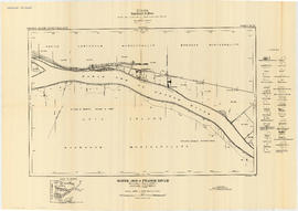
Fraser River - Sand heads sheet
Part of City of Vancouver Archives technical and cartographic drawing collection

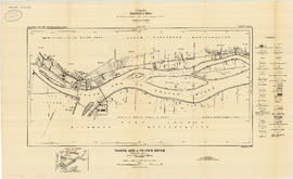
Fraser River - Steveston sheet
Part of City of Vancouver Archives technical and cartographic drawing collection

Part of City of Vancouver Archives technical and cartographic drawing collection

Fraser River - Deas Island sheet
Part of City of Vancouver Archives technical and cartographic drawing collection

Fraser River - Tilbury Island sheet
Part of City of Vancouver Archives technical and cartographic drawing collection

Fraser River - Annacis Island sheet
Part of City of Vancouver Archives technical and cartographic drawing collection

Fraser River - New Westminster sheet
Part of City of Vancouver Archives technical and cartographic drawing collection

Fraser River - Port Mann sheet
Part of City of Vancouver Archives technical and cartographic drawing collection

North Arm of Fraser River - Poplar Island sheet
Part of City of Vancouver Archives technical and cartographic drawing collection
North Arm of Fraser River - Boundary Road sheet
Part of City of Vancouver Archives technical and cartographic drawing collection
North Arm of Fraser River - Marpole sheet
Part of City of Vancouver Archives technical and cartographic drawing collection

North Arm of Fraser River - Ione Island sheet
Part of City of Vancouver Archives technical and cartographic drawing collection

North Arm of Fraser River - Point Grey sheet
Part of City of Vancouver Archives technical and cartographic drawing collection

Burrard Inlet - Vancouver sheet
Part of City of Vancouver Archives technical and cartographic drawing collection

Burrard Inlet - Second Narrows sheet
Part of City of Vancouver Archives technical and cartographic drawing collection

Burrard Inlet - Dollarton sheet
Part of City of Vancouver Archives technical and cartographic drawing collection

Part of City of Vancouver Archives technical and cartographic drawing collection

Burrard Inlet - Port Moody sheet
Part of City of Vancouver Archives technical and cartographic drawing collection

Fraser River - triangulation control
Part of City of Vancouver Archives technical and cartographic drawing collection
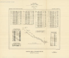
North Arm of Fraser River - triangulation control
Part of City of Vancouver Archives technical and cartographic drawing collection

Burrard Inlet - triangulation control
Part of City of Vancouver Archives technical and cartographic drawing collection
Jericho Park Habitat Survey Volume A and Volume B
Christmas Bird Count data collection sheets, 1995
Christmas Bird Count data collection sheets, 2001
Christmas Bird Count data collection sheets, 2002
Christmas Bird Count data collection sheets, 2008
Christmas Bird Count data collection sheets, 2010
Christmas Bird Count data collection sheets, 2013
Christmas Bird Count data collection sheets, 2015
Jericho Park Habitat Survey Data Form sheets
Christmas Bird Count data collection sheets, 1996
Christmas Bird Count data collection sheets, 1997
Christmas Bird Count data collection sheets, 1999
Christmas Bird Count data collection sheets, 2003
Christmas Bird Count data collection sheets, 2004
Christmas Bird Count data collection sheets, 2005
Christmas Bird Count data collection sheets, 2006
Christmas Bird Count data collection sheets, 2016