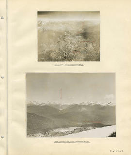
Aerial view - Lower Cheakamus Region and View looking east across Cheakamus Valley
- COV-S40-MAP 939-: LEG1153.036
- Item
- [1931]
Part of City of Vancouver fonds
316 results directly related Exclude narrower terms
Aerial view - Lower Cheakamus Region and View looking east across Cheakamus Valley
Part of City of Vancouver fonds
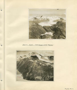
Aerial views - Garibaldi Lake region
Part of City of Vancouver fonds
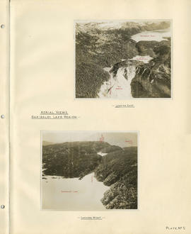
Aerial views - Garibaldi Lake region
Part of City of Vancouver fonds

Part of City of Vancouver Archives technical and cartographic drawing collection

Burrard Inlet - Dollarton sheet
Part of City of Vancouver Archives technical and cartographic drawing collection

Burrard Inlet - Port Moody sheet
Part of City of Vancouver Archives technical and cartographic drawing collection

Burrard Inlet - Second Narrows sheet
Part of City of Vancouver Archives technical and cartographic drawing collection

Burrard Inlet - triangulation control
Part of City of Vancouver Archives technical and cartographic drawing collection

Burrard Inlet - Vancouver sheet
Part of City of Vancouver Archives technical and cartographic drawing collection

Part of Major Matthews collection
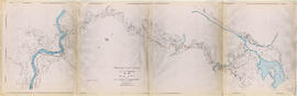
Item is a copy of a portion of a manuscript map of Burrard Inlet, created during the H.M.S. Plumper survey of the area. Sheet shows the eastern portion of the Inlet, including the southern portion of the North Arm.
United Kingdom. Admiralty

Part of City of Vancouver Archives technical and cartographic drawing collection
Map shows a survey conducted by the Canadian Pacific Railway of English Bay, Burrard Inlet and Coal Harbour, including a rough outline of area and lots. Note on map reads "Certified as a correct plan showing the land required for right of way Burrard Inlet B.C., February 22, 1886. H.J. Cambie, Engineer in Charge." Map is certified as correct and signed by various C.P.R. officials, including W.C. Van Horne.

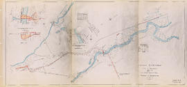
Cheakamus power survey for City of Vancouver 1930-1931. General plan and profile
Part of City of Vancouver fonds
Item is a map depicting south-western British Columbia and noting the location of the area covered by the plates in the atlas. The sheet also includes a profile of the survey area from Cheakamus Lake to Garibaldi Lake.

Part of City of Vancouver fonds
Item is a group of charts depicting flows by month measured at various points along the Cheakamus River.

Part of City of Vancouver fonds
Item is a sheet depicting a topographical map of the planned development from Garibaldi Lake to Daisy Lake. The sheet also includes a profile along the proposed tunnel and pipeline route.

Part of City of Vancouver fonds
Item is a topographic map of Cheakamus Lake, showing elements of the proposed power infrastructure. The map also includes an inset topographic map of the proposed dam site and a capacity diagram of Cheakamus Lake.
Part of City of Vancouver fonds
Item is a map sheet containing three topographical maps, depicting the Cheakamus River and Brandywine Creek, the dam site at Brandywine Creek ,and the proposed dam site near McGuire. The sheet also includes sectional drawing of the McGuire dam site, as well as charts of pondage at McGuire and Brandywine.

Part of City of Vancouver fonds

Part of City of Vancouver fonds

Part of City of Vancouver fonds

Cheakamus power survey for City of Vancouver 1930-1931. Proposed storage reservoir at Daisy Lake
Part of City of Vancouver fonds
Item is a map sheet containing two maps depicting portions of the Cheakamus River at or near Daisy Lake, with proposed power infrastructure. The sheet also contains charts depicting a capacity diagram for Daisy lake reservoir and cross-sections at Dyke #1 and Dyke #2.
Part of City of Vancouver fonds
Part of City of Vancouver fonds
Item is a map which appears to depict a proposed route for a pole line from a power house on the Cheakamus River to the Squamish River, as well as other unidentified sketches.
Cheakamus River. Brandywine Creek to Cheakamus Lake
Part of City of Vancouver fonds
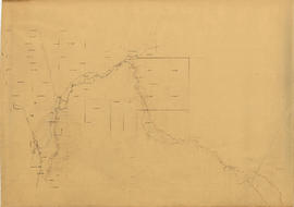
Item is a rough preliminary sketch map of part of the Cheakamus River. The map includes notes on terrain, survey data points, the PGE railway right of way, and District Lots.

Cheakamus River valley with possible dam location
Part of City of Vancouver fonds
Item is a sheet with three maps depicting a possible dam site on the Cheakamus River: a topographical map of the site with the dam location annotated, a cross-section depicting the geology of the dam site, and a profile of the tentative location of a tunnel.

Cheakamus River with proposed dam site at McGuire
Part of City of Vancouver fonds
Item is a sheet with three maps depicting a possible dam site on the Cheakamus River near McGuire: a topographical map of the site with the dam location annotated, and a cross-section depicting the geology of the dam site.
Check list survey of multi-problem families
Chehalis River and Harrison Lake
Part of City of Vancouver fonds
Item is a map sheet containing draft or preliminary versions of maps of the Chehalis River and Harrison Lake, relating to surveys conducted by H. Idsardi.

Chilliwack Lake scheme & Jones Lake scheme
Part of City of Vancouver fonds
Item is a map depicting proposed hydro-electric development north-west of Chilliwack Lake. The map shows the location so proposed dams, flumes, tunnels and the location of a power house on the Fraser River west of Jones Lake.
Part of City of Vancouver fonds
Item is a map sheet showing a map, traverse data, cross-section from Chilliwack Lake to the BC Electric Railway line west of Cultus Lake.
Christmas Bird Count data collection sheets, 1995
Christmas Bird Count data collection sheets, 1996
Christmas Bird Count data collection sheets, 1997
Christmas Bird Count data collection sheets, 1998
Christmas Bird Count data collection sheets, 1999
Christmas Bird Count data collection sheets, 2000
Christmas Bird Count data collection sheets, 2001
Christmas Bird Count data collection sheets, 2002
Christmas Bird Count data collection sheets, 2003
Christmas Bird Count data collection sheets, 2004
Christmas Bird Count data collection sheets, 2005
Christmas Bird Count data collection sheets, 2006
Christmas Bird Count data collection sheets, 2007
Christmas Bird Count data collection sheets, 2008
Christmas Bird Count data collection sheets, 2009
Christmas Bird Count data collection sheets, 2010
Christmas Bird Count data collection sheets, 2011
Christmas Bird Count data collection sheets, 2012
Christmas Bird Count data collection sheets, 2013
Christmas Bird Count data collection sheets, 2014