![[A part of Joyce Road (Street)]](/uploads/r/null/7/5/75473de28a4d07476fc7b54573c83f4ffa463e42bdd1649afdeb535feed7968a/9f5049ba-2311-4c7d-9589-f89a8e1a1896-A62740_142.jpg)
[A part of Joyce Road (Street)]
- AM54-S4-2-: CVA 371-2251
- Item
- 1913
Part of Major Matthews collection
79 results directly related Exclude narrower terms
[A part of Joyce Road (Street)]
Part of Major Matthews collection
![Boundary Road and Park Avenue [Vanness Street] Station](/uploads/r/null/7/4/5/7454a742bd98a374f4d947f025601d8fb773a9d430b79f0ede14ce9844527c3b/c746218c-84b8-4d56-8a01-01c1c07d955c-CVA371-818_142.jpg)
Boundary Road and Park Avenue [Vanness Street] Station
Part of Major Matthews collection
![Boundary Road and Park Avenue [Vanness Street] Station](/uploads/r/null/1/5/158b957e2f59bf46258a58be7442e2890bfe702e8ed04418b64c917a83c29e26/ee14a5f7-6c67-40c8-931b-4dc21bcddcdd-A37339_142.jpg)
Boundary Road and Park Avenue [Vanness Street] Station
Part of Major Matthews collection
Corner 25th Avenue and Main Street, Vancouver, B.C.
Part of Major Matthews collection
Photograph shows the Walden Block at 4112 Main Street, streetcar and automobiles on Main Street. J.S. Matthews' notes with print or negative in Archives.
![Finished bitulithic pavement Fraser St. and 34th Ave. [now 33rd Ave.]](/uploads/r/null/c/e/ced8cd4412754133f7d8b463ccd8ac13af0a8edf3f6aa85b1badc6e4af86de92/2bf50e3c-64a8-4efa-b475-59422ab6f306-A19292_142.jpg)
Finished bitulithic pavement Fraser St. and 34th Ave. [now 33rd Ave.]
Part of Major Matthews collection
![[Horse and cart travelling along] 34th Avenue [now 33rd Ave.] before paving](/uploads/r/null/1/b/1bea09e65d46b4109283423d33373961bada71fdd08bf41e25c639f1387eb3a6/ec202a7a-9fdb-4901-9fe9-d5885081dc3d-A19285_142.jpg)
[Horse and cart travelling along] 34th Avenue [now 33rd Ave.] before paving
Part of Major Matthews collection
![[Horse and cart travelling along 34th Avenue (now 33rd Avenue) before paving]](/uploads/r/null/5/8/58accbe9066b3a5afac554e1ad18cdf02097c9d7ed41cdcb5fd1f274eecd26dd/9e97a0b1-fb21-43e0-bdb6-846e105fa9f6-A19268_142.jpg)
[Horse and cart travelling along 34th Avenue (now 33rd Avenue) before paving]
Part of Major Matthews collection
![[Houses in South Vancouver]](/uploads/r/null/9/6/96beb114cdd36eb0925112d2fd5239b964d9de446cf79bd3c538c89ef082f0b8/090fc4d6-bd26-46bc-835f-1b2282ac15df-A19300_142.jpg)
Part of Major Matthews collection
Photograph shows houses on a residential street with wooden sidewalks and an unpaved road.
![[Looking north from Kingsway at Joyce Road (Street)]](/uploads/r/null/5/4/54da2c7ede6039c5ec882ae8f4244c0a549f175dec50cf7a39402b7f5608511e/bd288290-b957-49b5-b2a1-da73bb7c7379-A62737_142.jpg)
[Looking north from Kingsway at Joyce Road (Street)]
Part of Major Matthews collection
Photograph shows an unpaved road and part of Collingwood East
![Main and 26th Ave. [looking north], Vancouver, B.C.](/uploads/r/null/0/8/08f0657dbe7830c5909f22641b2933d128535a864f047897e1efac8a45725c5e/0190250f-3004-4810-ae8f-1382213102fa-A04453_142.jpg)
Main and 26th Ave. [looking north], Vancouver, B.C.
Part of Major Matthews collection
J.S. Matthews' notes with print or negative in Archives.
![Main St. and 17th Ave. [looking north]](/uploads/r/null/b/3/b3380bb884ee7a8abac63dac3db8e22d0e65982e440c0d9e7a43832360b0b9d2/ef766592-a7b5-4c13-8b42-c6fa72ea48d5-A04458_142.jpg)
Main St. and 17th Ave. [looking north]
Part of Major Matthews collection
Photograph shows Winram Block on the left. J.S. Matthews' notes with print or negative in Archives.
![Main St. and 17th Ave. [looking north]](/uploads/r/null/b/6/b69b92827011055a8c2981f9b2b97996b879bcf17c0a37d2b9663f8a535351eb/43be4bd9-e8e5-459b-85ca-a670ce48b46e-A04457_142.jpg)
Main St. and 17th Ave. [looking north]
Part of Major Matthews collection
Photograph shows Winram Block on the left. J.S. Matthews' notes with print or negative in Archives.
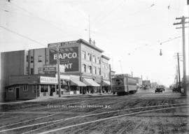
![Main St. and 25th Ave. [looking south] Vancouver, B.C.](/uploads/r/null/0/8/08cfe09cabe09306b4abcdd0bbc671968ca95776880ab30e7dc4752ee802122d/bedd2e3b-3c6e-4604-a77f-d2e59229a971-A04454_142.jpg)
Main St. and 25th Ave. [looking south] Vancouver, B.C.
Part of Major Matthews collection
Photograph shows the Walden Block at 4112 Main Street, with the "Bapco" sign on it. J.S. Matthews' notes with print or negative in Archives.

Marine Drive in South Vancouver
Part of Major Matthews collection
![Marine Drive in South Vancouver [near Gilman Road]](/uploads/r/null/c/b/cb21c73d09af6b33588908064d3c486d5114e65b6b26605659414dffe283daad/c012cea0-6bed-47e5-822d-d4185dd65f60-A25926_142.jpg)
Marine Drive in South Vancouver [near Gilman Road]
Part of Major Matthews collection
![[People entering streetcar on Main Street at 25th Avenue]](/uploads/r/null/7/3/73e5b03273a4342e33703d759e95195f161d4b05b3c73be4d76ba5118bebd463/d73b91e1-7630-459f-ae97-2cd75375f37e-A04880_142.jpg)
[People entering streetcar on Main Street at 25th Avenue]
Part of Major Matthews collection
Photograph shows streetcars, pedestrians, and buildings on either side of the street. J.S. Matthews' notes with print or negative in Archives.
![[Street car outside the Winram Block, 17th and Main St.]](/uploads/r/null/e/1/e14e644a588b3f93678f4c964d20100150b12ddfe3bf74e33850981e29b76c8b/a52e4081-8f51-4943-a4c5-3fadd9085e6b-A19271_142.jpg)
[Street car outside the Winram Block, 17th and Main St.]
Part of Major Matthews collection
![[Surveyors on street in South Vancouver]](/uploads/r/null/b/0/b09502a2af3b99222d80fd5668c89eb6ad7f009934c53dd430cadad418ffe532/5b53049e-48db-4876-9ec4-b4adcbb0e6e0-A19303_142.jpg)
[Surveyors on street in South Vancouver]
Part of Major Matthews collection

Vancouver, British Columbia, south-easterly portion, formerly South Vancouver : major street plan
Part of City of Vancouver Archives technical and cartographic drawing collection
Item is a map which has been removed from a copy of the report "A plan for the City of Vancouver, British Columbia, including Point Grey and South Vancouver and a general plan of the region", commissioned by the Vancouver Town Planning Commission from the planning consultants Harland Bartholomew & Associates.
The map shows major streets of sufficient width, major streets to be widened, new major street connections, present street widths, present lines of vehicles, present roadway widths, proposed street widths, proposed lines of vehicles, proposed roadway widths and pleasure drives in the area of the former Municipality of South Vancouver.
Harland Bartholomew and Associates
![[View of 33rd Avenue showing road work in progress]](/uploads/r/null/b/3/b3d6aa7eb8fb0bf11bef829f4930510c09435ec0ead8048f44cfbf1708600abf/b1595b8e-b135-4c1d-a4e8-8737f2850cd0-A19297_142.jpg)
[View of 33rd Avenue showing road work in progress]
Part of Major Matthews collection
![[View of] 34th Ave [now 33rd Ave] showing bitulithic paving](/uploads/r/null/1/5/15414121a12f5fa073fca9e2c5389404bfae71a44dd49b8a52e6efc7ea4096d9/38ff3049-ffb8-490e-ba3d-9b6da6192256-A19286_142.jpg)
[View of] 34th Ave [now 33rd Ave] showing bitulithic paving
Part of Major Matthews collection
![[View of] 56th Avenue](/uploads/r/null/5/e/5e6e63808539d76e2bb1611fb7f58e19d6ff2f5c79c8c0fb9a41ae096f1041e3/c876d1dc-483f-4911-be0a-4ea8219a7537-A19232_142.jpg)
Part of Major Matthews collection
![[View of a dirt road, possibly 33rd Avenue, with street car tracks along one side]](/uploads/r/null/c/6/c64e9d504cc9b533bf0c5d0399db85273e1137fd7e3945aa2e84aa82a215b053/db19eae9-2562-40d9-9249-b36cc0c36f0b-A19282_142.jpg)
[View of a dirt road, possibly 33rd Avenue, with street car tracks along one side]
Part of Major Matthews collection
![[View of an intersection on Kingsway]](/uploads/r/null/c/f/cfe400afd470037c32921b61c3e288beb498141a4ed40bba8a293220e8bfdf44/71808117-63ec-4d3d-a3fc-57f737009105-A19334_142.jpg)
[View of an intersection on Kingsway]
Part of Major Matthews collection
![[View of Cedar Cottage Road (Commercial Street) at the B.C.E.R. tracks at18th Avenue]](/uploads/r/null/c/e/ce59d93d446113ad663f487043aa0290516ae51fd4f8e3b5edd38c1e439e1256/311cf77c-bd71-4a2c-b7d4-c2e32e684736-A61086_142.jpg)
[View of Cedar Cottage Road (Commercial Street) at the B.C.E.R. tracks at18th Avenue]
Part of Major Matthews collection
![[View of finished] Paving Main St. and 17th Ave. looking north [showing the Winram block]](/uploads/r/null/5/b/5bac016b96314bbeb917b4e377d1ee1841c46536089bb447fecfdd79e090d3ee/b572beb9-fb07-4eb5-bda9-9431a294e603-A19258_142.jpg)
[View of finished] Paving Main St. and 17th Ave. looking north [showing the Winram block]
Part of Major Matthews collection
![[View of intersection probably River Avenue, now Marine Drive, and Fraser Street]](/uploads/r/null/6/4/6452707075abe1664e358d730eaeb4c51f71f6ce92a5dd0e0f63dfe4efc6b183/2af5de23-d671-4a66-bcb0-386ae624da78-A19355_142.jpg)
[View of intersection probably River Avenue, now Marine Drive, and Fraser Street]
Part of Major Matthews collection
![[View of Joyce Street looking south west towards Carleton School]](/uploads/r/null/6/5/65fddfb53fec807e9ed3476cea8eed909270066ae00a0cc4c69987f1c05de56e/5da90945-5972-46b9-8b35-bd078632aec3-A19313_142.jpg)
[View of Joyce Street looking south west towards Carleton School]
Part of Major Matthews collection
![[View of] Main St. and 51st Ave. looking north](/uploads/r/null/f/8/f883edec5ff5f43b5a87451c288ebdd8ac155bbc70a6da73860b2397d6cd3d41/ba858f93-e41e-4f01-b6e1-113768409322-A19260_142.jpg)
[View of] Main St. and 51st Ave. looking north
Part of Major Matthews collection
![[View of Main Street looking north from about 64th Avenue]](/uploads/r/null/a/7/a731d8302c523c6979f46e7674ec30b321dcb3566a777e687c30268e03a6d0ca/2bcbccc2-7bc7-48f4-a4a8-bbafd71760c3-A37088_142.jpg)
[View of Main Street looking north from about 64th Avenue]
Part of Major Matthews collection
![[View of Main Street looking north from the river bank]](/uploads/r/null/d/b/db98e883bbdc151f270cd3471629ad5f509b7c38028d1ca3c2913bfc7a2e6004/6ab1fd0d-8c7a-4104-a4f8-d74669739de2-A37158_142.jpg)
[View of Main Street looking north from the river bank]
Part of Major Matthews collection
![[View of Main Street, looking north from 26th Avenue]](/uploads/r/null/4/c/4cbdef125de15aa81c70e8709b292d5e4f274528f32b6cb2a2105258b3cafcb5/e6b7109b-66b4-4835-afc6-7609526820c9-A07868_142.jpg)
[View of Main Street, looking north from 26th Avenue]
Part of Major Matthews collection
J.S. Matthews' notes with print or negative in Archives.
![[View of road paving at the] Intersection Main St. and 34th Ave. [now 33rd Avenue]](/uploads/r/null/e/b/eb7cbb6633178207f5f6cba577f32455439dead88a072ac334180ac063701e1a/ee3c2d88-476a-4a4c-b0c8-13120cd63792-A19287_142.jpg)
[View of road paving at the] Intersection Main St. and 34th Ave. [now 33rd Avenue]
Part of Major Matthews collection
![[View of streetcar and businesses at] 49th and Fraser Aves. S[outh] Vancouver](/uploads/r/null/5/7/576330d6b9b9241916a75cabbb1b0f4006e91e6fa5e73dc92d69ed96e9d4b816/e8274e7d-e6c9-447a-80f1-7dda03a6d63f-A04452_142.jpg)
[View of streetcar and businesses at] 49th and Fraser Aves. S[outh] Vancouver
Part of Major Matthews collection
J.S. Matthews' notes with print or negative in Archives.
![[View of streetcar, automobile, and businesses at] 25th and Fraser Avenue. S[outh] Vancouver, B.C.](/uploads/r/null/9/0/901e8753c8b56d423c574b4d67cb84c95748fc6eca91b25bb09f09dfd40eecc6/92a75128-a994-4238-8f0a-cbc46c8ab828-A04451_142.jpg)
[View of streetcar, automobile, and businesses at] 25th and Fraser Avenue. S[outh] Vancouver, B.C.
Part of Major Matthews collection
![[View of the 3500 block Commercial Street looking north from 20th Avenue]](/uploads/r/null/f/1/f1b0bce3d006392eacb862cfcf2dcf83c3f8413c7c9f87b3a1112ba5d9f95899/45c4154f-fb02-4471-bfe7-f45508705373-A07869_142.jpg)
[View of the 3500 block Commercial Street looking north from 20th Avenue]
Part of Major Matthews collection
Photograph shows the Bank of Hamilton, Jackson Hardware Co. and the Bank of Vancouver.
![[View of the] Main St. bog [between 33rd Avenue and 41st Avenue]](/uploads/r/null/7/f/7fb80b09ebfd64e91e42bdfb033c7901f4187e4e47fb8a675f55ecce664255be/0d0df890-2794-44d1-b878-b21f154e60b1-A19256_142.jpg)
[View of the] Main St. bog [between 33rd Avenue and 41st Avenue]
Part of Major Matthews collection
Water service map of South Vancouver
Part of City of Vancouver fonds
Item is a sectional map showing water services, streets, district lots, house numbers, and size of lots in South Vancouver. Map was used by the Water Works Department and the Engineering Department until about 1945, and has been annotated to show changes in street names and address block numbers.

Part of City of Vancouver fonds

Part of City of Vancouver fonds

Part of City of Vancouver fonds

Part of City of Vancouver fonds

Part of City of Vancouver fonds

Part of City of Vancouver fonds

Part of City of Vancouver fonds

Part of City of Vancouver fonds

Part of City of Vancouver fonds

Part of City of Vancouver fonds

Part of City of Vancouver fonds

Part of City of Vancouver fonds