
- AM54-S4-2-: CVA 371-2451
- Item
- [ca. 1920]
Part of Major Matthews collection
Photograph shows railroad tracks
85 results directly related Exclude narrower terms
Part of Major Matthews collection
Photograph shows railroad tracks

Part of Major Matthews collection
Photograph shows an unidentified street with a bus stop and a railroad crossing sign
![Front St. from Lytton Sq. [after fire of September 10, 1898]](/uploads/r/null/0/3/0325a5cf8adf3cbfee425aef792e461732afb0973d9bb845393fe5d4d115c8ac/f81346df-1e11-45e6-ab08-79097eaaa408-A08674_142.jpg)
Front St. from Lytton Sq. [after fire of September 10, 1898]
Part of Major Matthews collection
J.S. Matthews' notes with print or negative in Archives.
Greater Vancouver and New Westminster : Wrigley's official arrow city map
Part of City of Vancouver Archives technical and cartographic drawing collection
Item is a street map of Vancouver, West Vancouver, North Vancouver, Burnaby, New Westminster and the northern part of Richmond, with street index and advertisements on verso and an attached cover.
Part of City of Vancouver Archives technical and cartographic drawing collection
Item is a road map showing Greater Vancouver on one side and downtown Vancouver and New Westminster on the other. Item also includes textual information for tourists and motorists.
![[Guichon Block improvements, corner of Columbia St. and 4th Street, New Westminster]](/uploads/r/null/9/e/9eb04d90eed36b4ee5de96c87693d72a6e58fa8bae054bc0d8be559414570e70/fa71ef20-b378-4f1f-8924-b0de3b5216ab-CVA810-2_142.jpg)
[Guichon Block improvements, corner of Columbia St. and 4th Street, New Westminster]
Photograph shows the Guichon block from Columbia Street looking towards 4th Street. The building is under scaffolding on which hangs a "Forsts" sign.
Guichon Block, Columbia St. and 4th Street, New Westminster
Photograph shows the Guichon Block on the corner of Columbia St. and 4th Street in New Westminster. It includes a partial image of the Burr Block next door on the left and details of the Columbia St. and the intersection in the foreground.
![Looking down Columbia St. from top of Burr block [after fire of September 10, 1898]](/uploads/r/null/3/5/3508071c7b441a9b8b364078f37d3c2a836c36a7f8ba7cfc9861042091cba91d/86f4a42e-9688-4f9c-b38c-cdf51ca84027-A08672_142.jpg)
Looking down Columbia St. from top of Burr block [after fire of September 10, 1898]
Part of Major Matthews collection
J.S. Matthews' notes with print or negative in Archives.

Map of Burnaby and New Westminster, British Columbia
Part of City of Vancouver Archives technical and cartographic drawing collection
Part consists of a street map of Burnaby and New Westminster, information on bus and street car routes, and text advertising the products and services of the Dominion Map and Blueprint Company.

Map of downtown section of Vancouver ; Diagram of New Westminster, B.C., downtown section
Part of City of Vancouver Archives technical and cartographic drawing collection
Part contains road maps of downtown Vancouver and New Westminster, and textual information for tourists and motorists.

Part consists of a street map of the Lower Mainland and Fraser Valley from Vancouver to Chilliwack, a street map of New Westminster, a map of Vancouver and North Vancouver showing street names but not street lines, and text advertising the products and services of the Dominion Map and Blueprint Company.

Map of Fraser Valley ; Street map of New Westminster ; Map of Greater Vancouver transit lines
Part consists of a street map of the Lower Mainland and Fraser Valley from Vancouver to Chilliwack, a street map of New Westminster, a map showing transit lines in Greater Vancouver, and text advertising the products and services of the Dominion Map and Blueprint Company.
Map of New Westminster and Burnaby with street directory indicated by dial
Item is a street map of New Westminster and Burnaby. Item includes a dial (a numbered circle, a paper indicator, a grid of block numbers and a street index used to find locations).

Part contains directions for using the dial map and the street index. Part includes Major Matthews's annotation that the map was "Presented, 23 Apr. 1942, by Robt. Morton, publisher, 2119 Maple St. aged 87."
![[Men walking down] Columbia St., New Westminster [after fire of] Sept. 1898](/uploads/r/null/1/b/1b0f8051c619dd47fba03b78f9da32d37b7a382fb0d7c4f4dc80e58fc6ed40ff/50804529-08a4-4686-99b8-cf9572aa0687-A08675_142.jpg)
[Men walking down] Columbia St., New Westminster [after fire of] Sept. 1898
Part of Major Matthews collection
J.S. Matthews' notes with print or negative in Archives.

Part of John William Freeston fonds
Panoramic view showing McLennan's Drug Store, Western Modern Business School, Columbia Street including City Hall and part of the Fraser River Bridge

Item is a photograph showing a street with shops in New Westminster.
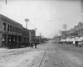
New Westminster, B.C. Columbia Street
Photograph shows streetcar tracks in the middle of the street, and businesses on either side. Also shown are various horse-drawn carts, and two men crossing the street.
New Westminster, British Columbia
Part of City of Vancouver Archives technical and cartographic drawing collection
Map shows the portion of New Westminster south of Columbia Street to the Fraser River. Land subdivision for the area is shown and streets are identified. Inset shows the location of New Westminster in relation to the rest of the Lower Mainland, B.C.
![[Rear view of Burr and Guichon Block, 401-419 Columbia Street, New Westminster]](/uploads/r/null/0/8/082af37313f5024fbdc04e691fb122ca1c057adbd5dfbe665062b94b3e9c88ab/98c2823c-6b85-47ec-8e47-18536c76d48f-CVA810-68_142.jpg)
[Rear view of Burr and Guichon Block, 401-419 Columbia Street, New Westminster]
Photograph shows the rear view of the Burr and Guichon blocks on Columbia Street from across the intersection at 4th Avenue and ? Street. Parked cars, sidewalks and trees are visible in the photograph. Businesses shown include Apex Cleaners.
![[Retail and Office building on Columbia St., New Westminster]](/uploads/r/null/6/1/611ef86761a3abd14c8174edb58d4be410fc0273e4634942c8921c35723db0b9/889bfb27-3706-4882-b3d2-579b1d96dbc2-CVA810-40_142.jpg)
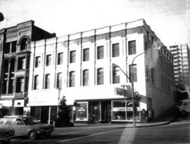
[Retail and Office building on Columbia St., New Westminster]
Photograph shows the a two storey mixed-use retail and office building on Columbia Street in New Westminster. It also shows cars parked along Columbia Street.
Sectional map and street directory of Vancouver : Dial map of the city of Vancouver
Item is a street map showing Vancouver on one side and Burnaby and New Westminster on the other, as well as information on street car and bus routes, and text advertising the products and services of the Dominion Map and Blueprint Company.
Sectional map and street directory of Vancouver : Dial map of the city of Vancouver
Part of City of Vancouver Archives technical and cartographic drawing collection
Item is a street map showing Vancouver on one side and Burnaby and New Westminster on the other, as well as information on street car and bus routes, and text advertising the products and services of the Dominion Map and Blueprint Company.
Item is a street map showing Vancouver, Burnaby, New Westminster, West Vancouver, and North Vancouver on one side and Lulu Island and Sea Island, Delta, Surrey, Langley and Maillardville on the other.
Part of City of Vancouver Archives technical and cartographic drawing collection
Item is a street map showing Vancouver, Burnaby, New Westminster, West Vancouver, and North Vancouver on one side and the Lower Mainland from Vancouver to Chilliwack on the other. Item includes lists of businesses, schools, public buildings, hospitals, bathing beaches, fire halls, and golf and country clubs, as well as text advertising the products and services of the Dominion Map and Blueprint Company.
![[The King Edward Hotel 400-block Columbia St., New Westminster]](/uploads/r/null/9/8/9835ce24059bcaab32b6b8bd51ced5839e0679da3914f98154849d0076e2eb6f/4c737700-9ea9-4fc9-91e9-3be02e101995-CVA810-41_142.jpg)
[The King Edward Hotel 400-block Columbia St., New Westminster]
Photograph shows the King Edward Hotel in the 400 block of Columbia Street in New Westminster. It also shows cars parked and driving along Columbia Street.

Part of City of Vancouver Archives technical and cartographic drawing collection
Map shows Hastings Town-site, Granville Town-site, Burnaby, and the City of New Westminster. Map also shows the Road from Granville and the False Creek Trail, as well as the names of places and soil types found along these roads. Other places and structures noted include Burrard Inlet, Coal Harbour (Coal Harbor on map), False Creek, False Creek Bridge, Burnaby Lake, Fraser River, New Westminster and Burrard Inlet Road, Douglas Road, Edinburgh Street, Columbia Street, Richards Street, and the New Westminster Cemetery. Two notes on map read "Plan to accompany Report of 1st May 1883, Joseph Hunter" and "Memo: Mr. Ross will place [?] this map to the [Engs.] Office Victoria [?]." 14T3 Roads & Trails is printed on the side of the map.

Transit detail inset maps ; Street index ; Transit and tourist information
Part consists of three maps showing transit details in Richmond, New Westminster and downtown Vancouver, and descriptive information about B.C. Electric routes and services and Greater Vancouver attractions.
![[View of 6th Street near Queens Avenue looking south toward Royal Avenue]](/uploads/r/null/b/1/b160f7797343556b798a72318857b08502b193549f365d8e89ebdf0249172387/6353b72d-7ccd-45de-b0dc-0f034f9211f6-A61044_142.jpg)
[View of 6th Street near Queens Avenue looking south toward Royal Avenue]
Part of Major Matthews collection
![[View of Columbia Street]](/uploads/r/null/e/f/ef93d73651c288cd13bec183ae441b073bef56fd8e1478d1e8606db139c05f97/fffbb383-9d42-4db1-944b-a41bd8bd0042-A33175_142.jpg)
Part of Major Matthews collection
![[View of Columbia Street]](/uploads/r/null/5/4/54eced867db69ed084037b81efedfe66e18b836275808398e6d7d8df2b8e00f5/21889ce7-573a-4dd0-a27f-769cd8194f18-A61052_142.jpg)
Part of Major Matthews collection
Panoramic view showing T.J. Hardware House Furnishings, the Edison Theatre, The Fair, Mills Clothing and other businesses and buildings and The Fraser River Bridge in the background
![[View of Columbia Street from Begbie Street after the fire]](/uploads/r/null/9/e/9e4dec33bb4620d4856992e51992f5441b0d5a2697908885a9c9cfe45d5675d3/2002ab05-3851-4e5c-a3b2-4e70da6dcc47-A33028_142.jpg)
[View of Columbia Street from Begbie Street after the fire]
Part of Major Matthews collection

Part of Major Matthews collection

Part of Major Matthews collection
Part of Major Matthews collection
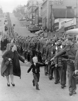
Photograph shows the British Columbia Regiment, D.C.O.R. marching down Eighth Street prior to embarkation overseas and Douglas Bernard, Jack Douglas Bernard and Bernice Bernard