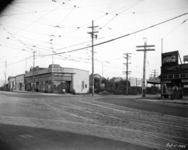
![Hastings Mill Store [exterior]](/uploads/r/null/f/5/c/f5cf0fe642b8882900f2adb126174f3d1a35a06dfbd00d0012fdf575050a2963/5e49a145-ad24-4d9f-a014-4b8cc242510b-CVA229-01_142.jpg)
Hastings Mill Store [exterior]
- AM1376-: CVA 229-01
- Item
- [ca. 1909]
Hastings Mill Store [exterior]

Holland Block and 300 block Water Street
Part of Art Grice fonds
Item is a photograph of Holland Block at the intersection of Water Street and Cordova Street, looking east primarily down Water Street. The building houses the Pharaoh's Retreat nightclub (264 Water Street) on the ground floor and signage reading "Design Art interior & indu[strial]" is in the window on the second floor. The Woodwards W sign is visible in the background down Cordova Street.

Hornby and Robson Street intersection
Part of City of Vancouver fonds
Item is a photograph of the shops across the intersection of Hornby Street and Robson Street, looking northwest up Robson Street. Signage and storefronts of several businesses are visible: the Toronto Dominion Bank (1000 Robson), Murchie's Tea and Coffee Ltd. (1008 Robson Street), O'Brian Optician and Jewellers (1016 Robson Street), Happy Feet Shoe and Repair (1028 Robson Street), Schnitzel House (1060 Robson Street), and the European News & Import House (1044 Robson Street) on the left, The Card Shop (1001 Robson Street) and White Spot (1025 Robson Street) on the right. The Sheraton Landmark hotel is visible in the background.
Hornby and Robson Street intersection
Part of City of Vancouver fonds
Item part is a photograph of the shops across the intersection of Hornby Street and Robson Street, looking northwest up Robson Street. Signage and storefronts of several businesses are visible: the Toronto Dominion Bank (1000 Robson), Murchie's Tea and Coffee Ltd. (1008 Robson Street), O'Brian Optician and Jewellers (1016 Robson Street), Happy Feet Shoe and Repair (1028 Robson Street), Schnitzel House (1060 Robson Street), and the European News & Import House (1044 Robson Street) on the left, The Card Shop (1001 Robson Street) and White Spot (1025 Robson Street) on the right. The Sheraton Landmark hotel is visible in the background.
Hornby and Robson Street intersection
Part of City of Vancouver fonds
Item part is a photograph of the shops across the intersection of Hornby Street and Robson Street, looking northwest up Robson Street. Signage and storefronts of several businesses are visible: the Toronto Dominion Bank (1000 Robson), Murchie's Tea and Coffee Ltd. (1008 Robson Street), O'Brian Optician and Jewellers (1016 Robson Street), Happy Feet Shoe and Repair (1028 Robson Street), Schnitzel House (1060 Robson Street), and the European News & Import House (1044 Robson Street) on the left, The Card Shop (1001 Robson Street) and White Spot (1025 Robson Street) on the right. The Sheraton Landmark hotel and the Blue Horizon hotel are visible in the background.
![Horne Building and Springer-Van Bramer [Brinsmead] Building, Cordova Street and Cambie Street](/uploads/r/null/7/0/c/70c509ed912653320aabfa817d83e8619302bc48f3fd13cc8668f9c9e0d82f3b/c16a9428-0370-4f0c-85ef-5ce9cba05f2d-CVA70-64_142.jpg)
Horne Building and Springer-Van Bramer [Brinsmead] Building, Cordova Street and Cambie Street
Part of Art Grice fonds
Item is a photograph of the Springer-Van Bramer block (also called Springer-Van Braemer block, the Brinsmead Building, and the Masonic Temple building, 301 W. Cordova Street) and the adjacent J.W. Horne Block (315 - 321 W. Cordova Street) taken from an upper floor on Cambie Street [most likely of the Dominion Building], looking down onto the blocks.

Hotel Europe, 43 Powell Street, front facade
Part of Art Grice fonds
Item is a photograph of the narrow front of Hotel Europe (43 Powell Street) from Maple Tree Square, near Water Street. Sections of Powell Street and Alexander Street are visible to the left and right of the hotel, and the statue of 'Gassy' Jack is visible on the left.

Hotel Europe, 43 Powell Street, front facade
Part of Art Grice fonds
Item is a photograph of the narrow front of Hotel Europe (43 Powell Street) from Maple Tree Square. Sections of Powell Street and Alexander Street are visible to the left and right of the hotel.

Interior of Magloire Desrosiers' store, his assistants and their wares

Interior of Grandview Table Supply grocery store with the shopkeeper and his assistants

Interior of O.K. Grocery Store, 2353 East Hastings at Nanaimo
Item is a photograph showing the interior of O.K. Grocery Store at 2353 East Hastings at Nanaimo. Pictured: Frank Williams, Alan Leith, Tom Williams and Ray Churchland.

Interior of O.K. Stores Ltd., 686 Kingsway
Item is a photograph showing the interior of O.K. Stores Ltd. at 686 Kingsway. Pictured (L-R): Norm Ross, Jack Wadge and Frank Williams.

Interior of Old Country Bakery, 1064 Robson Street
Part of City of Vancouver fonds

Interior of Rays' Superior Store, 4469 W. 10th Avenue
Item is a photograph showing the interior of Rays' Superior Store at 4469 W. 10th Avenue. Pictured (L-R): Frank Williams, Roy Treasurer and George Tryon.
![Interior of Rooney's Millinery Store [Gordon Millinery at 603 W Hastings?]](/uploads/r/null/7/f/a/7fa6913221798d3d31c097473b33b2989e3fec444cde300778fd02134658ff2b/db8c3d12-ac13-40a7-a126-57f2a2dccf5d-CVA198-4_142.jpg)
Interior of Rooney's Millinery Store [Gordon Millinery at 603 W Hastings?]
Item is a photograph showing the interior of Rooney's Millinery Store, possibly in the Empire Building. Pictured are the shop assistants Mable Rooney and "Babe" Rooney.

Interior of tinsmiths workshop with the proprietor, Magloire Desrosiers and his assistants

Interior of unidentified grocery store with shoppers, clerks, and stock
Part of City of Vancouver fonds
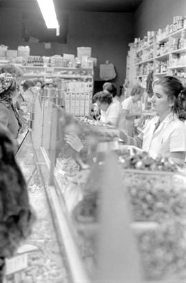
Interior of unidentified grocery store with shoppers, clerks, and stock
Part of City of Vancouver fonds

Interior of unidentified grocery store with shoppers, clerks, and stock
Part of City of Vancouver fonds

Interior of unidentified grocery store with shoppers, clerks, and stock
Part of City of Vancouver fonds

Interior view of W.H. Walsh Grocer
Item is a photograph showing grocery store employees and various canned goods and other items on display, including garden seeds and salmon, as well as a view of the cash register. The business was located at 1200 Seymour Street, at the corner of Seymour and Davie.
Interior view of W.H. Walsh Grocer
Item is a photograph showing a woman standing near displays of shoe polish, corn flakes and other goods. Other store employees are visible in the background. The business was located at 1200 Seymour Street, at the corner of Seymour and Davie.

Interior view of W.H. Walsh Grocer
Item is a photograph showing six employees standing behind the counter and displays of merchandise. The business was located at 1200 Seymour Street, at the corner of Seymour and Davie.
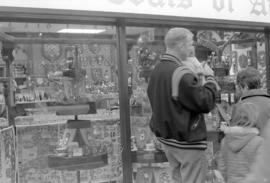
International Coats of Arms, front window
Part of City of Vancouver fonds
Item part is a photograph of a front window of International Coats of Arms (160 Water Street) in Gastown. Visible through the window is a variety of collectable items, with a focus on various coats of arms.

Intersection of Burrard Street and Robson Street
Part of City of Vancouver fonds
Item part is a photograph of the shops across the intersection of Burrard Street and Robson Street, looking northwest up Robson Street Some of the establishments visible are the Toronto Dominion Bank (1000 Robson), Murchie's Tea and Coffee Ltd. (1008 Robson Street), The Card Shop (1001 Robson Street), White Spot (1025 Robson Street), and several other unidentified establishments in the area. The Sheraton Landmark hotel is visible in the background.

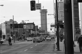
Intersection of Robson Street and Bute Street
Part of City of Vancouver fonds
Item part is a photograph of the intersection of Robson Street and Bute Street, looking northwest. Visible on the right is the Blue Horizon Hotel (1225 Robson Street), and on the left is the Sheraton Landmark hotel (1400 Robson Street), under construction.

Intersection of Robson Street and Hornby Street
Part of City of Vancouver fonds
Item part is a street photograph from the corner of Hornby Street and Robson Street, looking northwest down Robson Street The Bar-B-Q World Famous Delicatessen (904 Robson Street), Modern Design & Mexican Gift Shop (906 Robson Street), and the signage for Rippy's Fine Foods are visible across the intersection. Other retail shops are visible along the street.

Intersection of Water Street and Cambie Street
Part of Art Grice fonds
Item is a photograph of the intersection of Water Street and Cambie Street, looking west down Water Street.

Kingsway at Beatrice, post improvements
Item is a photograph of Kingsway at Beatrice, looking southeast, after the Kingsway improvements. Identified establishments visible in the photograph include Kingsway Woodworks, Geo. Collett Boot & Shoe Hospital, Steele and Co., and the Tyrell Block.

Kingsway at Beatrice, pre improvements
Item is a photograph of Kingsway at Beatrice, looking southeast, before the Kingsway improvements. Identified establishments visible in the photograph include Kingsway Woodworks, Steele and Co., and the Tyrell Block.
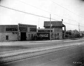
Kingsway at Commercial Drive, Natal Garage, post improvement
Item is a photograph of Kingsway at Commercial Drive looking west at the southwest corner of the intersection, after the Kingsway improvements. The photograph shows the Natal Garage and service station and a convince store. Coca-Cola and Orange Crush signs are on the side of the convenience store. The new sidewalks, utility poles with street lamps, and the newly expanded road are all visible.

Kingsway at Commercial Drive, Natal Garage, pre improvement
Item is a photograph of Kingsway at Commercial Drive looking west at the southwest corner of the intersection, before the Kingsway improvements. The photograph shows a small corner store, the Natal Garage and service station, and a building under construction. Coca-Cola and Orange Crush signs are on the side of the corner store, and a delivery truck for Fletcher's No. 1 Bacon is at the service station.

Kingsway at Commercial, post improvements
Item is a photograph of intersection of Kingsway and Commercial, looking south-east, after the Kingsway improvements. The identified establishments in the photograph are Kingsway Drug Co. Ltd, Fletcher's Meats Co. (Fletcher's No 1 Bacon on sign), and Scott's Home Bakery.

Kingsway at Commercial, pre improvements
Item is a photograph of intersection of Kingsway and Commercial, looking south-east, before the Kingsway improvements. The identified establishments in the photograph are Kingsway Drug Co. Ltd, Fletcher's Meats Co. (Fletcher's No 1 Bacon on sign), and Scott's Home Bakery.

Kingsway at Knight Street, southwest corner, post improvements
Item is a photograph of Kingsway at Knight Street, southwest corner, looking east, after the Kingsway improvements. The photograph shows the new sidewalk in front of Herbert Eldridge Drugs, the widened section of Kingsway, and the fully renovated fence and sidewalk sections across Knight Street. New billboards on Knight Street have advertisements for Forst's Radio (selling Philco radios) and City Coal Co.

Kingsway at Knight Street, southwest corner, pre improvements
Item is a photograph of Kingsway at Knight Street, southwest corner, looking east, before the Kingsway improvements. The photograph shows the sidewalk in front of Herbert Eldridge Drugs and the fence and sidewalk sections across Knight Street that would be soon renovated.
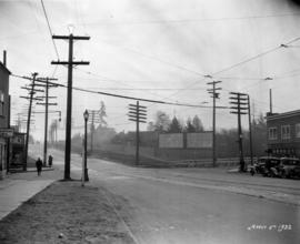
Kingsway at Knight, looking southeast at intersection
Item is a photograph of the intersection of Kingsway and Knight Street, looking southeast, during the Kingsway improvements. On the left edge the signage for Ideal Fish & Chips can be seen, and on the corner across Knight is Ed's Fish & Chips. The newly constructed fence and billboards are visible at the southeast corner of the intersection in the upper right corner, but the road widening and other improvements have not been completed.
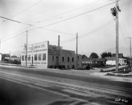
Kingsway at Perry Street, Jones Tent and Awning Co. Ltd., post improvements
Item is a photograph of Kingsway at Perry Street, looking northwest at the Jones & Son Tent and Awning Co. Ltd. Building. This photograph was taken after the Kingsway expansion and other new street improvements had taken place. The building has been shortened on front, with a new facade, and expanded on the back.

Kingsway at Perry Street, Jones Tent and Awning Co. Ltd., pre improvements
Item is a photograph of Kingsway at Perry Street, looking northwest at the Jones & Son Tent and Awning Co. Ltd. Building. This photograph was taken before the building was shortened to make room for street widening and other improvements.
Kingsway at Victoria Drive, southeast, post improvements
Item is a photograph of the intersection of Kingsway and Victoria Drive, looking southeast, after the Kingsway improvements. Identified establishments on the southeast corner include the empty W. H. A. Van Alstine Drugs location (the old sign is visible behind the building) and Maple Leaf Barber Shop. There is a billboard for Shell Gasoline across the intersection further along Victoria. New utility poles, street light, and sidewalks care visible in the photograph, and the buildings have been renovated to accommodate the widened street.

Kingsway at Victoria Drive, southeast, pre improvements
Item is a photograph of the intersection of Kingsway and Victoria Drive, looking southeast, before the Kingsway improvements. Identified establishments on the southeast corner include W. H. A. Van Alstine Drugs, George Collett Boot and Shoe Hospital (before its move to the 1900 block of Kingsway), Maple Leaf Barber Shop, and Bell's Grocery. Across Kingsway in the right of the photograph is Star Grocery. There is a billboard for Turret Cigarettes across the intersection on Victoria.

Kingsway at Victoria Drive, southwest, post improvements
Item is a photograph of the intersection of Kingsway and Victoria Drive, looking southwest, after the Kingsway improvements. The corner of the empty W. H. A. Van Alstine Drugs location can be seen across Kingsway on the southeast corner of the intersection, on the southeast corner of the intersection an unidentified grocery store and W. S. Parcells real estate can be seen. Advertisements for Coca-Cola and Turret Cigarettes are visible on the grocery store building.

Kingsway at Victoria Drive, southwest, pre improvements
Item is a photograph of the intersection of Kingsway and Victoria Drive, looking southwest, before the Kingsway improvements. W. H. A. Van Alstine Drugs can be seen across Kingsway on the southeast corner of the intersection, on the southeast corner of the intersection Star Grocery, White Produce, and W. S. Parcells real estate can be seen. Advertisements for Coca-Cola, Toronto Dominion Trusts, and Seal Brand coffee are visible on the grocery store building.

Kingsway between Knight and Dumfries, looking northwest
Item is a photograph of Kingsway, between Knight Street and Dumfries Street, looking northwest. The awnings and partial storefronts of Stella Mae's Dressmaking and Ed's Fish & Chips are visible along the sidewalk leading up to Knight Street on the right. Diagonally across the Kingsway and Knight Street intersection several local businesses can be seen, including the Wayside Barber Shop, Sun Chong & Co., and Flemons.

Kong's Corner Store and Handy Meats, Campbell Avenue and East Georgia Street
Part of Art Grice fonds
Item is a photograph of Kong's Corner Store (898 E. Georgia Street) at the corner of Campbell Avenue and E. Georgia Street. Further along E. Georgia Street can be seen Handy Meat Market (844 E. Georgia Street).

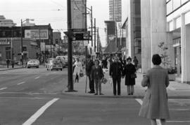
Macdonald's Prescriptions, Helen's Beauty Salon, Air Canada
Part of City of Vancouver fonds
Item part is a photograph of a group people waiting on the sidewalk outside a set of shops on the ground floor of the Medical-Dental Building (925 W. Georgia Street), taken from across the street. The establishments identified are Macdonald’s Prescriptions Ltd. (929 W. Georgia), Helen’s Beauty Salon Ltd. (925 W. Georgia) and an Air Canada location (905 W. Georgia).

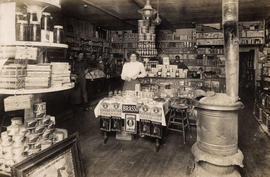
Magloire Desrosiers standing inside his tinsmiths store
Item is a photograph showing Magloire Desrosiers inside his tinsmiths store. He was the proprietor of two shops located at 214 Carrall Street and at 625 Hamilton Street.

Man with stroller outside grocery store
Part of City of Vancouver fonds
Item part is a photograph of a man with a stroller examining vegetables outside an unidentified grocery store on Robson Street.
Maple Tree Square looking east from Water Street
Part of City of Vancouver fonds
Item part is a photograph of Maple Tree Square, looking east from the north sidewalk of Water Street. On the right the signage and awning of The Quest (Quest Team Three design projects Ltd., 1 Alexander Street) is visible. Across the square is Hotel Europe (43 Powell Street, at Alexander). On the left the identified establishments are Gassy's Joint (6 Powell Street) and The Boiler Room (8 Powell Street).
Maple Tree Square looking south at Carrall Street
Part of City of Vancouver fonds
Item part is a photograph from Maple Tree Square looking at the Carrall Street entrance to the square. The photograph features the Galerie Allen (213 Carroll Street), the entrance to Gaoler’s Mews, several unidentified establishments, and traffic and pedestrians in the square.