- AM1594-: MAP 649
- Item
- [before Oct. 1923]
Part of City of Vancouver Archives technical and cartographic drawing collection
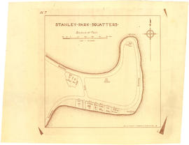
Item is a copy of a map showing a portion of Stanley Park and parcels of land labelled with surnames of identified squatters.
5 results directly related Exclude narrower terms
Part of City of Vancouver Archives technical and cartographic drawing collection
Item is a copy of a map showing a portion of Stanley Park and parcels of land labelled with surnames of identified squatters.
![Squatters at Deadman's Island [photo taken for the "Star"]](/uploads/r/null/c/b/cbff0ee421fd5d4a4a828524c9f2df195984b4d6b46d8a0bcec77c9b2b00ac00/58baf1d0-23e7-4068-b3dc-288945be9839-A01101_142.jpg)
Squatters at Deadman's Island [photo taken for the "Star"]
Part of Stuart Thomson fonds
![Squatters at Deadman's Island [photo taken for the "Star"]](/uploads/r/null/3/0/307eeea105807e20ecec7193c7c4ce3ced6710396a096efd1032ab6d26b1afbe/864c99e3-f5ee-449b-b234-f5a542efad36-A01100_142.jpg)
Squatters at Deadman's Island [photo taken for the "Star"]
Part of Stuart Thomson fonds

Old squatters' shacks, Stanley Park
![Deadman's Island [showing squatters' houses]](/uploads/r/null/3/c/3cf6c3afa39878f6987ecdb169f8ae27f95c56b13d8b9d103ac6334f7596c45a/c55d4d05-d0a2-45c4-b4e4-bf6457bcb032-A02395_142.jpg)
Deadman's Island [showing squatters' houses]
Photograph is accompanied by a label reading: "This is the famous Dead Man's Island. Island or Peninsula? Off Stanley Park. This picture shows the shacks of the squatters. It was the intention to build a sawmill on this site, but the citizens objected. Trees were cut down and the residents notified to vacate. Nothing became of the granting of a lease over the island - Timms Photo."