- AM1519-: PAM 1991-43
- Item
- 1991
Item is a brochure including history of restoration and map.
28 results directly related Exclude narrower terms
Item is a brochure including history of restoration and map.
Part of City of Vancouver Archives technical and cartographic drawing collection
Item is a map depicting an area bounded by the following streets: Blanca Drive to English bay to the northeast corner of the University Endowment Lands to Fourth Avenue.
Part of City of Vancouver Archives technical and cartographic drawing collection
Item is a map depicting an area bounded by the following streets: Ontario Street (west side only) to approximate location of modern West 69th Avenue to Fremlin Avenue to the Fraser River.

Part of City of Vancouver Archives technical and cartographic drawing collection
Item is a map depicting an area bounded by the following streets: Shaughnessy Street to Townsend Road [now West 70th Avenue] to east portion of District Lot 317 to the Fraser River.

Part of City of Vancouver Archives technical and cartographic drawing collection
Item is a map depicting an area bounded by the following streets: Ontario Street to Essex Street/Sixty-first Avenue West to Fremlin Avenue to Townsend Road [now West 70th Avenue].
![Plate 45: Eburne [Fremlin Avenue - Buckberry Road - DL 317 - Townsend Road]](/uploads/r/null/5/5/9/5598cfd0ce990ca7fe898ca616c8d59032103fcbbb1ac971f056446b55c6f85c/969c2d6f-977a-423a-a251-279ae90cd87b-MAP342a_142.jpg)
Plate 45: Eburne [Fremlin Avenue - Buckberry Road - DL 317 - Townsend Road]
Part of City of Vancouver Archives technical and cartographic drawing collection
Item is a map depicting an area bounded by the following streets: Fremlin Avenue (west side only) to Buckberry Road [now Park Drive] (south side only) to east portion of District Lot 317 to Townsend Road [now West 70th Avenue] (north side only).

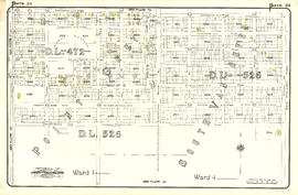
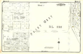
Plate 44: East portion of District Lot 526
Part of City of Vancouver Archives technical and cartographic drawing collection
Item is a map depicting an area bounded by the following streets: Ontario Street to Fifty-first Avenue to Oak Street to approximate location of modern West 61st Avenue..
![Plate 43: Point Grey [Oak Street - Fifty-third Avenue - Maple Street - Sixty-first Avenue]](/uploads/r/null/0/1/2/0128f370e81c187f858e4dd8d1c56123f245fac386e61c2814dac4e42c3fb5e1/2d462a46-87dc-44f5-892d-bf76b2a0c867-MAP342a_142.jpg)
Plate 43: Point Grey [Oak Street - Fifty-third Avenue - Maple Street - Sixty-first Avenue]
Part of City of Vancouver Archives technical and cartographic drawing collection
Item is a map depicting an area bounded by the following streets: Oak Street (west side only) to appoximate location of modern West 53rd Avenue to approximate location of modern Maple Street to approximate location of modern West 61st Avenue.

Part of City of Vancouver Archives technical and cartographic drawing collection
Item is a map depicting an area bounded by the following streets: Ontario Street to appoximate location of modern West 39th Avenue to Oak Street to Forty-ninth Avenue (Point Grey)/Fifty-first Avenue (South Vancouver).
![Plate 41: Point Grey [Oak Street - Forty-third Avenue - Maple Street - Fifty-third Avenue]](/uploads/r/null/5/c/4/5c49ce9e62c8124e60724ba4658ef672c9a8577a72b7470712e755f225e5e53c/40c68f07-c590-4dd6-8980-19dae2c185f8-MAP342a_142.jpg)
Plate 41: Point Grey [Oak Street - Forty-third Avenue - Maple Street - Fifty-third Avenue]
Part of City of Vancouver Archives technical and cartographic drawing collection
Item is a map depicting an area bounded by the following streets: Oak Street to approximate location of current West 43rd Avenue to approximate location of current Maple Street to approximate location of current West 53rd Avenue.

Part of City of Vancouver Archives technical and cartographic drawing collection
Item is a map depicting an area bounded by the following streets: approximate location of current Maple Street to Forty-ninth Avenue (south side only) to Carnarvon Street (east side only) to approximate location of current West 54th Avenue and western edge of District Lot 325A.

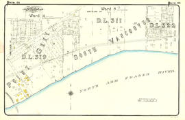
Part of City of Vancouver Archives technical and cartographic drawing collection
Item is a map depicting an area bounded by the following streets: Carnarvon Street (west side only) to Fifty-first Avenue (south side only) to Fraser River to Bruce Street [now Wallace Street]/Musqueam Reserve.
![Plate 38: Kerrisdale [Maple Street - Thirty-ninth Avenue - Carnarvon Street - Forty-ninth Street]](/uploads/r/null/8/8/7/8877319961d5b79d8baacd1f17610d932fc144c32cdc4d51c091b6508e5f91ac/5003435f-0706-4579-9683-4be095514a59-MAP342a_142.jpg)
Plate 38: Kerrisdale [Maple Street - Thirty-ninth Avenue - Carnarvon Street - Forty-ninth Street]
Part of City of Vancouver Archives technical and cartographic drawing collection
Item is a map depicting an area bounded by the following streets: Maple Street (west side only) to Thirty-ninth Avenue (south side only) to Carnarvon Street (east side only) to Forty-ninth Avenue (north side only).
![Plate 37: Point Grey [Carnarvon Street - Forty-first Avenue - Crown Street - Fifty-first Avenue]](/uploads/r/null/e/5/4/e5420c03d3bc5ab6f2d354bd06f0606912e9fbc9a52335a42088fc2aaa6f0ffb/2b4101b5-1a7c-4531-9dca-881ac9509984-MAP342a_142.jpg)
Plate 37: Point Grey [Carnarvon Street - Forty-first Avenue - Crown Street - Fifty-first Avenue]
Part of City of Vancouver Archives technical and cartographic drawing collection
Item is a map depicting an area bounded by the following streets: Carnarvon Street (west side only) to Forty-first Avenue (south side only) to Crown Street (including two lots immediately west and northeast corner of Musqueam Reserve) to Fifty-first Avenue (north side only).

Part of City of Vancouver Archives technical and cartographic drawing collection
Item is a map depicting an area bounded by the following streets: Ontario Street (west side only) to Twenty-ninth Avenue to Oak Street (east side only) to approximate location of current West 39th Avenue.
![Plate 35: Shaughnessy [Oak Street - Thirty-third Avenue - Cypress Street - Forty-third Avenue]](/uploads/r/null/6/b/0/6b0eae693375c4dfe3401f5cd39a61247d72c892fbca308e4ddc56acb16a5ad1/2f2c15a3-f282-4f2f-b8f7-a655cf488ae9-MAP342a_142.jpg)
Plate 35: Shaughnessy [Oak Street - Thirty-third Avenue - Cypress Street - Forty-third Avenue]
Part of City of Vancouver Archives technical and cartographic drawing collection
Item is a map depicting an area bounded by the following streets: Oak Street (west side only) to Thirty-third Avenue (south side only) to Cypress Street (including 2/3 block immediately west) to Forty-third Avenue (north side only).
Part of City of Vancouver Archives technical and cartographic drawing collection
Item is a map depicting an area bounded by the following streets: Ontario Street (west side only) to Nineteenth Avenue West (south side only) to Oak Street (east side only) to Twenty-sixth Avenue/Twenty-fifth Avenue (north side only) and north part of District Lot 526.

Part of City of Vancouver Archives technical and cartographic drawing collection
Item is a map depicting an area bounded by the following streets: Oak Street (west side only) to Laurier Avenue/Matthews Avenue (south side only) to Cypress Street (including 1/2 block immediately west) to Thirty-third Avenue.

Part of City of Vancouver Archives technical and cartographic drawing collection
Item is a map depicting an area bounded by the following streets: Maple Street (incluing 2/3 block immediately east) to Twenty-ninth Avenue (south side only) to Carnarvon Street (east side only) to Thirty-ninth Avenue (north side only).
Part of City of Vancouver Archives technical and cartographic drawing collection
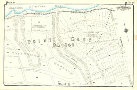
Item is a map depicting an area bounded by the following streets: Carnarvon Street (west side only) to Thirty-first Avenue (south side only) to Government Reserve to Forty-first Avenue (north side only).
Part of City of Vancouver Archives technical and cartographic drawing collection
Item is a map depicting an area bounded by the following streets: Maple Street to Nineteenth Avenue/18th Avenue to Carnarvon Street (east side only) to Twenty-ninth Avenue (north side only).
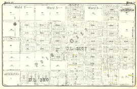
![Plate 29: Point Grey [Carnarvon Street - Twenty-first Avenue - Camosun Street - Thirty-first Avenue]](/uploads/r/null/3/6/d/36d64967233ead79fd5a60377f3c5e17df446e8fb639b21ee7558cddfd00f3ab/d5368109-f547-4d50-8e11-9e2ddea49dec-MAP342a_142.jpg)
Plate 29: Point Grey [Carnarvon Street - Twenty-first Avenue - Camosun Street - Thirty-first Avenue]
Part of City of Vancouver Archives technical and cartographic drawing collection
Item is a map depicting an area bounded by the following streets: Carnarvon Street (west side only) to Twenty-first Avenue (south side only) to Camosun Street (east side only) to Thirty-first Avenue (north side only).

Part of City of Vancouver Archives technical and cartographic drawing collection
Item is a map depicting an area bounded by the following streets: Oak Street to Thirteenth Avenue West (south side only) to Cypress Street (and 1/2 block immediately west) to Matthews Avenue and Laurier Avenue (north side only).
![Plate 24: Kitsilano [Maple Street - Eighth Avenue - Carnarvon Street - Nineteenth Avenue]](/uploads/r/null/b/a/0/ba0d68b19000d99c14b892626e97bedc7f45445a348eb8777d39028478ac4859/2cc1981f-874e-400e-9af5-afe630d81ebd-MAP342a_142.jpg)
Plate 24: Kitsilano [Maple Street - Eighth Avenue - Carnarvon Street - Nineteenth Avenue]
Part of City of Vancouver Archives technical and cartographic drawing collection
Item is a map depicting an area bounded by the following streets: Maple Street (including 1/2 block immediately east) to Eighth Avenue West (south side only) to Carnarvon Street (east side only) to Nineteenth Avenue West (north side only).
![Plate 23: Kitsilano [Carnarvon Street - Tenth Avenue - Crown Street - Twenty-first Avenue]](/uploads/r/null/c/b/9/cb9d797daebe3c23cc3ba0e3ab52ab602fa9dc4a36711e52ea66b2f98545e1ba/5287ebc9-ddb6-4554-a8ca-501a8cdcfd50-MAP342a_142.jpg)
Plate 23: Kitsilano [Carnarvon Street - Tenth Avenue - Crown Street - Twenty-first Avenue]
Part of City of Vancouver Archives technical and cartographic drawing collection
Item is a map depicting an area bounded by the following streets: Carnarvon Street (west side only) to Tenth Avenue West (south side only) to Crown Street (including 1/2 block immediately west) to Twenty-first Avenue (north side only).
![Plate 21: Kitsilano Carnarvon Street - English Bay - Crown Street - Tenth Avenue]](/uploads/r/null/4/2/8/428f96578655c794d997e5a6ff5007ddbcabb876cb06f8aec6efe8db1ca589dc/d66a7b24-0eaa-47f3-bfa5-0a39a8ee9943-MAP342a_142.jpg)
Plate 21: Kitsilano Carnarvon Street - English Bay - Crown Street - Tenth Avenue]
Part of City of Vancouver Archives technical and cartographic drawing collection
Item is a map depicting an area bounded by the following streets: Carnarvon Street (west side only) to English Bay to Crown Street and Federal Government Reserve to Tenth Avenue West (north side only).
![Plate 20: Point Grey [Crown Street - Sixth Avenue - Blanca Drive - Sixteenth Avenue]](/uploads/r/null/e/7/1/e7131a5080595ea160953fc209124d18fa23d64a87bff5a9e09a0f0548c21440/2ad33d97-773a-48a1-935e-20d3599a75b0-MAP342a_142.jpg)
Plate 20: Point Grey [Crown Street - Sixth Avenue - Blanca Drive - Sixteenth Avenue]
Part of City of Vancouver Archives technical and cartographic drawing collection
Item is a map depicting an area bounded by the following streets: Crown Street (west side only) to Sixth Avenue (south side only) to Blanca Drive (east side only) to Sixteenth Avenue (north side only).
![Plate 19: Point Grey [DL 176 - English Bay - Blanca Drive - Sixth Avenue]](/uploads/r/null/9/0/9/909403abc0abc4ea9b01b1fe9828873551fc26e82dc2e7e8f84af526c1a137b6/34b7af86-7d81-4ed5-9c84-a350059fc9b2-MAP342a_142.jpg)
Plate 19: Point Grey [DL 176 - English Bay - Blanca Drive - Sixth Avenue]
Part of City of Vancouver Archives technical and cartographic drawing collection
Item is a map depicting an area bounded by the following streets: the northwest corner of District Lot 176 to English Bay to Blanca Drive (east side only) to Sixth Avenue (north side only).