Title and statement of responsibility area
Title proper
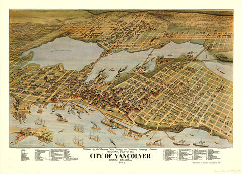
Panoramic view of the City of Vancouver, British Columbia, 1898
General material designation
- Cartographic material
Parallel title
Other title information
Title statements of responsibility
published by the Vancouver World Printing and Publishing Company, Limited
Title notes
Level of description
Item
Reference code
Edition area
Edition statement
Edition statement of responsibility
Class of material specific details area
Statement of scale (cartographic)
Not drawn to scale.
Statement of projection (cartographic)
Statement of coordinates (cartographic)
Statement of scale (architectural)
Issuing jurisdiction and denomination (philatelic)
Dates of creation area
Date(s)
Physical description area
Physical description
1 map : lithographic print, col., ill ; 77 x 107 cm
Publisher's series area
Title proper of publisher's series
Parallel titles of publisher's series
Other title information of publisher's series
Statement of responsibility relating to publisher's series
Numbering within publisher's series
Note on publisher's series
Archival description area
Custodial history
Scope and content
Item is a map showing an oblique aerial eye view of Vancouver, including Burrard Inlet, Upper False Creek Flats and False Creek. Streets, buildings and businesses are identified. Inset shows location of the Vancouver City foundry, Machine Works and Sugar Refinery. The map includes pictorial representations of buildings, industrial activity around Burrard Inlet, watercraft and vegetation. The perspective view of the map is to the south/south-east.
The map was originally included as a supplement to the Daily World newspaper.
Notes area
Physical condition
Immediate source of acquisition
Arrangement
Language of material
Script of material
Location of originals
Availability of other formats
Microfiche copy in Reading Room.
Restrictions on access
Terms governing use, reproduction, and publication
Finding aids
Associated materials
Accruals
General note
The Archives has copies of both the original 1898 map and one copy of the 1976 reproduction. Please note that the digitized version is of the reproduction, not the original.
External Link
ftp://webftp.vancouver.ca/archives/MAPS-TIFF/MAP547.tif
Format: TIFF (LZW compressed)
MD5: 4A559421D9CDDF284540A28544D7E02E
*Size: 47739488 bytes
Rights
Public domain
Alternative identifier(s)
Standard number area
Standard number
Access points
Subject access points
Place access points
Name access points
- Vancouver World Printing and Publishing Co. (Publisher)

