A brief for presentation to the commission of inquiry on forest resources of British Columbia
- AM1519-: PAM 1945-144
- Item
- 1945
47 results directly related Exclude narrower terms
A brief for presentation to the commission of inquiry on forest resources of British Columbia
Abstracts from reports of British Columbia land surveyors 18--

Part of City of Vancouver Archives technical and cartographic drawing collection
Part contains general information about British Columbia's government, economy, and resources, and text advertising the services of Western Development and Power Limited.
Brief history of game administration in British Columbia ...

Item is a map showing cities and towns, smaller settlements, post offices, railways, roadways, trading posts, ferries, hospitals, telegraph lines, government agents' offices, mining and sub-mining recording offices, falls and rapids, drainage flow, and park, provincial, and international boundaries. An inset map shows the southern Vancouver Island and Lower Mainland area in greater detail. Item includes road, rail, and coastal distance tables, lists of administrative offices and their locations, and an index of post offices.
British Columbia Canada [provincial information]
By-laws of the Corporation of the Harbour Commissioners of Vancouver, B.C.

Part of City of Vancouver Archives technical and cartographic drawing collection
Item is a map showing topography, roads, trails, railways, bridges, boundaries, reserves, power lines, telephone lines, triangulation stations, camera stations, bench marks, houses, barns, mills, factories, schools, churches, post offices, telephone exchanges, mines and geographic features in the Pitt Lake area, including Coquitlam Mountain, Mount Blanshard, and Siwash Island. A small index map shows the area covered by the primary map in relation to other maps in the series.
Part of City of Vancouver Archives technical and cartographic drawing collection
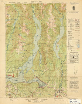
Item is a map showing topography, roads, trails, railways, bridges, boundaries, reserves, power lines, telephone lines, triangulation stations, camera stations, bench marks, houses, barns, mills, factories, schools, churches, post offices, telephone exchanges, mines and geographic features in the area of Indian Arm and Coquitlam Lake, extending south to Port Moody, Port Coquitlam, and the northeast part of Burnaby. A small index map shows the area covered by the primary map in relation to other maps in the series.
Great job robbery : a B.C. Electric story you'll never read in "The Buzzer"
Help us save our big game and fur bearing animals
![Howe Sound - Burrard Inlet [Burrard Inlet portion]](/uploads/r/null/f/8/5/f8523992bb5d5e0c1391f2dea183041a54a2d2470eb4047bb29958a0d835ae95/fdf9563d-923e-468a-a494-3ff190294b91-MAP30b_142.jpg)
Howe Sound - Burrard Inlet [Burrard Inlet portion]
Part of City of Vancouver Archives technical and cartographic drawing collection
Part shows the Lower Mainland and Burrard Inlet from Howe Sound in the west to Indian Arm in the east. Map shows topographic contour lines, elevations, lakes, streams and other natural features, roads, railways, communication lines, cities and other settlements, and land, timber, and mineral surveys by number. Includes a list of sources of information.
![Howe Sound - Burrard Inlet [Howe Sound portion]](/uploads/r/null/7/a/1/7a1896077ddc37a7e16ac2d7e42a66031e13e11a9d966c43fca06cbb56f8bd96/5edd8d92-d3cd-4663-8fdd-996b3ae7a402-MAP30a_142.jpg)
Howe Sound - Burrard Inlet [Howe Sound portion]
Part of City of Vancouver Archives technical and cartographic drawing collection
Part shows the Lower Mainland and Howe Sound from Britannia Beach in the northwest to Indian Arm in the southeast. Map shows topographic contour lines, elevations, lakes, streams and other natural features, roads, railways, communication lines, cities and other settlements, and land, timber, and mineral surveys by number.
Industrial survey of Vancouver and its adjacent territory.
Information and statistics relative to the establishment of industries in British Columbia, Canada

Map of the municipalities of New Westminster City and District, British Columbia
Part of City of Vancouver Archives technical and cartographic drawing collection
Part contains a map of the Lower Mainland and Fraser Valley from the Gulf of Georgia in the west to Harrison Lake in the east. Map shows locations of churches, schools, canneries, sawmills, brickyards, tanneries, woolen mills and hatcheries; existing and proposed railways; and roadways.

Part of City of Vancouver Archives technical and cartographic drawing collection
Item is a map showing topography, roads, trails, railways, bridges, boundaries, reserves, power lines, telephone lines, triangulation stations, camera stations, bench marks, houses, barns, mills, factories, schools, churches, post offices, telephone exchanges, mines and geographic features in the Pitt Meadows area and extending south through Cloverdale and Langley to the United States border. A small index map shows the area covered by the primary map in relation to other maps in the series.

Northerly portion Vancouver Island
Item is a map of northern Vancouver Island and the adjacent British Columbia coast showing Crown and reserve lands, timber leases, district, park, and provincial forest boundaries, cities, municipalities, villages, post offices, hospitals, roads, railways, seaplane ports and anchorages, airports, elevations of some geographical features, and marine distances in nautical miles.

Item is a copy of a British Columbia Department of Lands map of British Columbia north of the 55th parallel. Map shows cities and towns, smaller settlements, post offices, railways, roadways, trading posts, ferries, hospitals, telegraph lines, government agents' offices, mining and sub-mining recording offices, hatcheries, falls and rapids, drainage flow, and park, provincial, and international boundaries. An inset map shows the far northwest area not shown on the primary map.
Plan your firm's future where growth is assured by resources : Greater Vancouver has everything!

Part of City of Vancouver Archives technical and cartographic drawing collection
Item is a map of southwestern British Columbia from Bute Inlet to Alta Lake and Chilko Lake to northern Gabriola Island showing Crown granted land, surveyed timber leases and licenses, Indian Reserves, government reserves, land district and park boundaries, nautical distances, municipalities, cities and villages, telegraph and telephone lines, pipelines, railways, government agents' offices, mining and sub-mining recording offices, post offices, lighthouses, roads, and elevations of geographical features.

Preliminary map : Stikine River
Item is a map of the Stikine River region from Dease Lake in the north to Stewart in the south. Map shows land and timber surveys, government and First Nations reserves, mining division and international boundaries, government agents' offices, mining and sub-mining recording offices, post offices, villages, Hudson's Bay Company posts, telegraph lines, hospitals, schools, radio stations, triangulation stations, railways, roadways, bridges, falls and rapids, glaciers, and topographic contours.

Item is a map of the Prince Rupert, British Columbia area showing lands alienated or covered by applications under the Land Act, timber leases, First Nations reserves, land district, provincial forest, and park boundaries, forest management licences, municipalities, post offices, hospitals, sub-mining recording offices, railways, roadways, airports, seaplane anchorages, elevations, telephone and power lines, and glaciers. An index map shows the area covered by the primary map in relation to the rest of British Columbia and other maps published in the series.
Report of the ... annual meeting.
Report is a geological reconnaissance, No. 980.
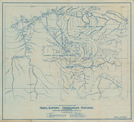
Sketch plan of north eastern Venezuelan Guyana
Part of John Leckie fonds
Item is a map showing rivers, diamond and gold deposits, former Spanish mission stations, farms, ranches, waterfalls, bush lines, railway projects, and state and national boundaries. Concentric circles show distances from Tumeremo. Additonal locations have been annotated in pencil.

South western British Columbia
Item is a map of southwestern British Columbia and northwestern Washington showing cities, municipalities, and settlements, post offices, government agents, railways, roads, ferry and steamship routes, air and seaplane ports, parks, campsites, glaciers, customs ports of entry, and elevations of mountains. Inset maps show the islands north of Cape Scott and the Seattle region. An small key map shows the primary map's location in relation to the rest of British Columbia and other maps published in the same series.
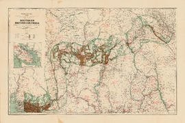
Southern British Columbia showing disposition of lands within the Railway Belt
Part of City of Vancouver Archives technical and cartographic drawing collection
Item is a map of the area from Howe Sound to Kootenay National Park showing homesteads, sales, special grants, mining land sales and provincial grants, Indian Reserves, forest reserves, timber berths, grazing leases and parks. Also indicated are locations of minerals, types of farming, fish and water power. An inset map shows southern Vancouver Island.
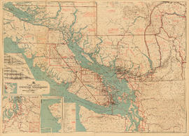
Part contains a commercial and visitors map of the southwestern land districts of British Columbia, encompassing Vancouver Island and the mainland from Seymour Inlet in the northwest to Black Pines in the northeast, extending south to Chiwaukum, Washington. Primary map shows settlements, government agent offices, mining and sub-mining recording offices, game reserves, customs posts, hospitals, ferries, campsites, golf courses, canneries, commercial air harbours, lighthouses, radio stations, motor boat refill stations, power sites, railways, roadways, trails, telegraph and telephone lines, steamship routes, topographic contour lines, and locations of falls and rapids. Text on the map provides information on land features and the presence of wild and farmed animals, and indicates current and possbile agricultural and industrial land use. Inset maps show the northern tip of Vancouver Island, Triangle Island and West and East Haycock Islands, and northwestern Washington State from Seattle to Centralia. A key map shows the location of the area covered by the main map in relation to the rest of North America.
Item contains a commercial and visitors map of the southwestern land districts of British Columbia on one side and textual information on the region on the other.

Southwestern districts : Map no. 1K : comparative geographical study
Part contains information on the southwestern districts of British Columbia, including population, climate, agriculture, industry, labour, and education; itineraries for exploring the various regions; information on Canadian customs regulations and game regulations; and diagrams of road routes to British Columbia from California and Alberta/western Washington.

Item is a map of the Terrace, British Columbia area showing lands alienated or covered by applications under the Land Act, timber leases, First Nations reserves, land district, provincial forest, and park boundaries, forest management licences, municipalities, post offices, hospitals, sub-mining recording offices, railways, roadways, airports, seaplace anchorages, elevations, telephone and power lines, and glaciers. An index map shows the area covered by the primary map in relation to the rest of British Columbia and other maps published in the series.
Includes oversize wall map by Louis Skoda.

Tongass National Forest, Alaska : Copper River Meridian
Item is a map of the Tongass National Forest showing roads, trails, railways, triangulation stations, dwellings, schoolhouses, mines, landing strips, airfields, and international, national forest, and national monument boundaries. Two smaller maps show the location of the Tongass National Forest in relation to the rest of Alaska and the far northwest portion of the forest not shown on the primary map.
Tour guide to Imperial Oil's Ioco refinery
Trans Mountain Oil Pipeline Company : official opening, Thursday, October 15th, 1953

Part of City of Vancouver Archives technical and cartographic drawing collection
Item is a map showing topography, roads, trails, railways, bridges, boundaries, reserves, power lines, telephone lines, triangulation stations, camera stations, bench marks, houses, barns, mills, factories, schools, churches, post offices, telephone exchanges, mines and geographic features in the area of southern Gambier Island, Bowen Island, Whytecliff, and Caulfeild. A small index map shows the area covered by the primary map in relation to other maps in the series.

Part of City of Vancouver Archives technical and cartographic drawing collection
Item is a map showing topography, roads, trails, railways, bridges, boundaries, reserves, power lines, telephone lines, triangulation stations, camera stations, bench marks, houses, barns, mills, factories, schools, churches, post offices, telephone exchanges, mines and geographic features in the area from Mount Hanover in the north through West Vancouver and North Vancouver, extending south to the northern part of Vancouver. A small index map shows the area covered by the primary map in relation to other maps in the series.
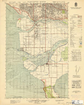
Part of City of Vancouver Archives technical and cartographic drawing collection
Item is a map showing topography, roads, trails, railways, bridges, boundaries, reserves, power lines, telephone lines, triangulation stations, camera stations, bench marks, houses, barns, mills, factories, schools, churches, post offices, telephone exchanges, mines and geographic features in the area of southern Vancouver and Richmond, extending south to the United States border. A small index map shows the area covered by the primary map in relation to other maps in the series.
![Vancouver, B.C., the Pacific coast terminus of the C.P.R. [Canadian Pacific Railway]](/uploads/r/null/8/3/f/83fcf65f0d66d64e6357d0d647e0ea6e2fa4aae4c3d1919f952d7725b4299cda/623e750c-fbab-43b7-a496-d20b384baeb6-LEG1321_142.jpg)
Vancouver, B.C., the Pacific coast terminus of the C.P.R. [Canadian Pacific Railway]
Part of City of Vancouver Archives technical and cartographic drawing collection
Part contains text and engravings describing Vancouver's climate, resources, industries, and buildings. Cover page is stamped "Arthur McMullen."
![Vancouver, B.C., the Pacific coast terminus of the C.P.R. [Canadian Pacific Railway]](/uploads/r/null/e/2/c/e2cdc004f3cf462100ed2ef053aa6087887b3f3200917cd5fba6292afb3b2d2d/bfcde3fa-32d7-4d08-86e5-ecf70c6f8388-LEG1340_142.jpg)
Vancouver, B.C., the Pacific coast terminus of the C.P.R. [Canadian Pacific Railway]
Part of City of Vancouver Archives technical and cartographic drawing collection
Part contains text and engravings describing Vancouver's climate, resources, industries, and buildings.
Water power and post-war employment

Item is a map of the central British Columbia coast including Haida Gwaii and the mainland from Stewart in the northwest to Kleena Kleene in the southeast. Map shows cities, municipalities, and settlements, post offices, government agents, railways, roads, ferry and steamship routes, air and seaplane ports, parks, campsites, glaciers, customs ports of entry, and elevations of mountains. An small key map shows the primary map's location in relation to the rest of British Columbia and other maps published in the same series.