
Assembly of Challenger relief map of British Columbia in P.N.E. B.C. Building
- AM281-S8-: CVA 180-5614
- Item
- [1954?]
22 results directly related Exclude narrower terms
Assembly of Challenger relief map of British Columbia in P.N.E. B.C. Building
![BSc Bldg : [people viewing Challenger relief map of British Columbia in P.N.E. B.C. Building]](/uploads/r/null/c/a/caad5fdf55aba6bfcccc92dd67bf940b5fc3c48cf4921edfca2f3c47bca5ec88/27d7a99f-b304-4b40-938a-c2307718ecd9-CVA180-5623_142.jpg)
BSc Bldg : [people viewing Challenger relief map of British Columbia in P.N.E. B.C. Building]

Challenger relief map of British Columbia in P.N.E. B.C. Building

Challenger relief map of British Columbia in P.N.E. B.C. Building

Challenger relief map of British Columbia in P.N.E. B.C. Building

Challenger relief map of British Columbia in P.N.E. B.C. Building

Challenger relief map of British Columbia in P.N.E. B.C. Building
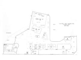
Item is a photographic reproduction of a drawing depicting the site map for the buildings used as a clearing station by the federal government at Hastings Park as part of the uprooting and mass displacement of Japanese Canadians.

Interested group of "Foresters" viewing giant Challenger relief map of B.C.
![Left to right: 1. PNE 2. Dr. Axel [Wenner-Gren?] 3. E.M. Gunderson](/uploads/r/null/c/3/c38a9c823ffd815c76b253669a741063ed24318f62e76a546724befda0f5f0ad/48d71778-ed0b-4aba-87ac-23c4162951d4-CVA180-5616_142.jpg)
Left to right: 1. PNE 2. Dr. Axel [Wenner-Gren?] 3. E.M. Gunderson
Item is a photograph showing men looking at the Challenger relief map on display.

People viewing Challenger relief map of British Columbia in P.N.E. B.C. Building

People viewing Challenger relief map of British Columbia in P.N.E. B.C. Building

People viewing Challenger relief map of British Columbia in P.N.E. B.C. Building
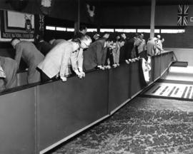
People viewing Challenger relief map of British Columbia in P.N.E. B.C. Building

People viewing Challenger relief map of British Columbia in P.N.E. B.C. Building

People viewing Challenger relief map of British Columbia in P.N.E. B.C. Building

People viewing Challenger relief map of British Columbia in P.N.E. B.C. Building

People viewing Challenger relief map of British Columbia in P.N.E. B.C. Building

People viewing Challenger relief map of British Columbia in P.N.E. B.C. Building

Percy Downyon - Kelowna Aquatic Ass'n and Kelowna Memorial Arena

Plan of the Vancouver Exhibition Grounds 1915
Item is a print made from a photographic negative in the holdings of the City of Vancouver Archives. The original map is annotated "1915" in the hand of J.S. Matthews.
